File:North Country Trail Locator Map US.svg
跳转到导航
跳转到搜索

此SVG文件的PNG预览的大小:800 × 417像素。 其他分辨率:320 × 167像素 | 640 × 333像素 | 1,024 × 533像素 | 1,280 × 667像素 | 2,560 × 1,333像素 | 1,859 × 968像素。
原始文件 (SVG文件,尺寸为1,859 × 968像素,文件大小:691 KB)
说明
说明
添加一行文字以描述该文件所表现的内容
| 描述 |
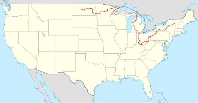
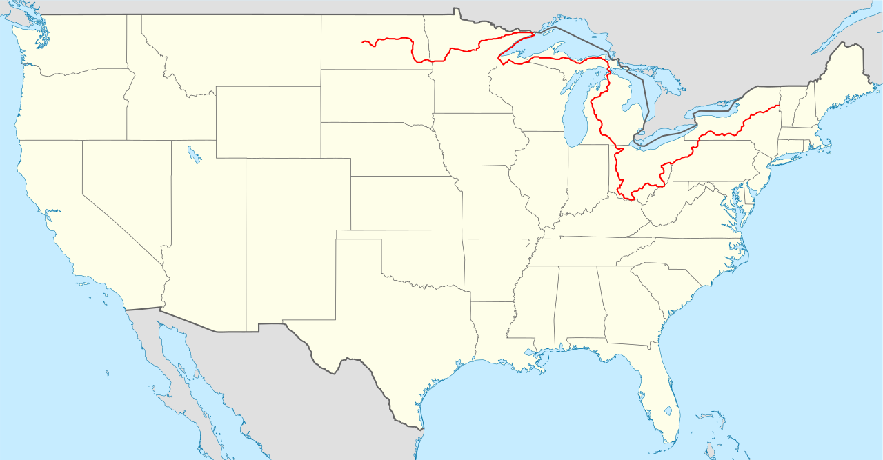
Locator map of the United States ("lower 48") with the North Country Trail overlayed. Equirectangular projection, N/S stretching 120 %. Geographic limits of the map:
|
| 日期 | (UTC) |
| 来源 |
|
| 作者 |
|
本文件采用知识共享署名-相同方式共享 3.0 未本地化版本许可协议授权。
- 您可以自由地:
- 共享 – 复制、发行并传播本作品
- 修改 – 改编作品
- 惟须遵守下列条件:
- 署名 – 您必须对作品进行署名,提供授权条款的链接,并说明是否对原始内容进行了更改。您可以用任何合理的方式来署名,但不得以任何方式表明许可人认可您或您的使用。
- 相同方式共享 – 如果您再混合、转换或者基于本作品进行创作,您必须以与原先许可协议相同或相兼容的许可协议分发您贡献的作品。
原始上传日志[编辑]
This image is a derivative work of the following image:
- File:USA_location_map.svg licensed with Cc-by-sa-3.0, GFDL
- 2008-07-29T20:04:42Z NordNordWest 1859x968 (738148 Bytes) {{Information |Description= {{de|Positionskarte der [[:de:Vereinigte Staaten|Vereinigten Staaten]]}} Quadratische Plattkarte, N-S-Streckung 120 %. Geographische Begrenzung der Karte: * N: 49.8° N * S: 24.2° N * W: 125.5° W
Uploaded with derivativeFX
文件历史
点击某个日期/时间查看对应时刻的文件。
| 日期/时间 | 缩略图 | 大小 | 用户 | 备注 | |
|---|---|---|---|---|---|
| 当前 | 2023年12月30日 (六) 20:01 | | 1,859 × 968(691 KB) | Bamyers99(留言 | 贡献) | Removed segment in Minnesota |
| 2011年2月9日 (三) 03:54 |  | 1,859 × 968(678 KB) | Bamyers99(留言 | 贡献) | {{Information |Description=Locator map of the United States ("lower 48") with the North Country Trail overlayed. Equirectangular projection, N/S stretching 120 %. Geographic limits of the map: * N: 49.8° |
您不可以覆盖此文件。
文件用途
以下页面使用本文件:
全域文件用途
以下其他wiki使用此文件:
- de.wikipedia.org上的用途
- en.wikipedia.org上的用途
- fr.wikipedia.org上的用途
- it.wikipedia.org上的用途
- www.wikidata.org上的用途
- zh.wikipedia.org上的用途