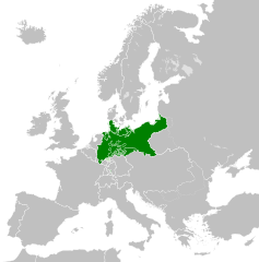
File:North German Confederation 1870.svg
Aller à la navigation
Aller à la recherche

Taille de cet aperçu PNG pour ce fichier SVG : 450 × 456 pixels. Autres résolutions : 237 × 240 pixels | 474 × 480 pixels | 758 × 768 pixels | 1 011 × 1 024 pixels | 2 021 × 2 048 pixels.
Fichier d’origine (Fichier SVG, nominalement de 450 × 456 pixels, taille : 705 kio)
Légendes
Légendes
Ajoutez en une ligne la description de ce que représente ce fichier
Description
[modifier]Cette image vectorielle SVG non W3C-spécifiée a été créée avec Inkscape .


.svg)
.svg)
.svg)
.svg)
.svg)


.svg)
.svg)
.svg)


.png)
.png)


.svg)


.svg)

.svg)


.svg)
.svg)
.svg)
.svg)


.svg)
.png)


.svg)


.svg)
.svg)


.svg)


.svg)


.svg)
.svg)
.svg)
.svg)
.svg)
.svg)
.svg)
_cropped.svg)
.svg)
.svg)
.svg)
.svg)
.svg)
.svg)
.svg)
.svg)
.svg)
.svg)
.svg)
.svg)
.svg)
.svg)
.svg)
.svg)
.svg)
.svg)
.svg)
.svg)
.svg)
.svg)
.svg)
.svg)
.svg)
.svg)
.svg)
.svg)
.svg)
.svg)
.svg)
.svg)
.svg)
.svg)
.svg)
.svg)
.svg)
.svg)
.svg)
.svg)
.svg)
.svg)
.svg)
.svg)
.svg)
Conditions d’utilisation
[modifier]
Ce fichier est sous la licence Creative Commons Attribution – Partage dans les Mêmes Conditions 4.0 International.
- Vous êtes libre :
- de partager – de copier, distribuer et transmettre cette œuvre
- d’adapter – de modifier cette œuvre
- Sous les conditions suivantes :
- paternité – Vous devez donner les informations appropriées concernant l'auteur, fournir un lien vers la licence et indiquer si des modifications ont été faites. Vous pouvez faire cela par tout moyen raisonnable, mais en aucune façon suggérant que l’auteur vous soutient ou approuve l’utilisation que vous en faites.
- partage à l’identique – Si vous modifiez, transformez, ou vous basez sur cette œuvre, vous devez distribuer votre contribution sous la même licence ou une licence compatible avec celle de l’original.
Historique du fichier
Cliquer sur une date et heure pour voir le fichier tel qu'il était à ce moment-là.
| Date et heure | Vignette | Dimensions | Utilisateur | Commentaire | |
|---|---|---|---|---|---|
| actuel | 1 juin 2016 à 02:58 | | 450 × 456 (705 kio) | Alphathon (d | contributions) | Various corrections to the states of the North German Confederation |
| 31 mai 2016 à 05:22 |  | 450 × 456 (662 kio) | Alphathon (d | contributions) | Uploaded wrong file | |
| 31 mai 2016 à 05:22 |  | 450 × 456 (725 kio) | Alphathon (d | contributions) | Minor corrections (Tarasp and post-1818 German Confederation border change) | |
| 31 mai 2016 à 02:40 |  | 450 × 456 (662 kio) | Alphathon (d | contributions) | == {{int:filedesc}} == {{Inkscape}} {{Information |Description={{en|A map of the en:North German Confederation within Europe circa 1870 CE.}} |Source= {{Derived from|Blank_map_of_Europe.svg|display=50}} |Date=2016-05-31 |Author=*[[:File:Bla... |
Vous ne pouvez pas remplacer ce fichier.
Utilisations locales du fichier
Plus de 100 pages utilisent ce fichier. La liste suivante affiche seulement les 100 premières pages qui utilisent ce fichier. Une liste complète est disponible.
- User:Alphathon/Historical Europe
- File:Albania 1956-1990.svg
- File:Albanian Kingdom (1935).svg
- File:Albanian Kingdom (1939).svg
- File:Austrian Lombardy 1789.svg
- File:Austrian Netherlands 1789.svg
- File:Austro-Hungarian Monarchy (1914).svg
- File:Blank map of Europe 1812.svg
- File:Blank map of Europe 1890.svg
- File:Blank map of Europe 1914.svg
- File:Blank map of Europe 1929-1938.svg
- File:Blank map of Europe 1956-1990.svg
- File:Blank map of Europe October 1938 - March 1939.svg
- File:Bulgaria 1956-1990.svg
- File:Confederation of the Rhine (1812).svg
- File:Cortina di ferro.png
- File:Czechoslovak Republic (1938).svg
- File:Czechoslovak Republic (1939).svg
- File:Czechoslovakia 1956–1990.svg
- File:Duchy of Holstein 1789.svg
- File:Duchy of Mecklenburg-Schwerin 1789.svg
- File:Duchy of Warsaw (1812).svg
- File:Duchy of Württemberg 1789.svg
- File:East Germany 1956-1990.svg
- File:Ecclesiastical lands of the Holy Roman Empire 1789.svg
- File:Electorate of Bavaria 1789.svg
- File:Electorate of Brunswick-Lüneburg 1789.svg
- File:Electorate of Saxony 1789.svg
- File:Europe 1789.svg
- File:Europe 1942.svg
- File:First French Empire 1812.svg
- File:Free City Danzig 1930.svg
- File:Free City of Danzig (1812).svg
- File:French Empire (1812).svg
- File:French State (1942).svg
- File:General Government (1942).svg
- File:German Empire 1914.svg
- File:German Reich (1939).svg
- File:Grand Duchy of Tuscany 1789.svg
- File:Grand Principality of Finland (1914).svg
- File:Greater German Reich (1942).svg
- File:Habsburg Monarchy 1789.svg
- File:Hellenic Republic (1935).svg
- File:Hellenic State (1942).svg
- File:Hungary 1956-1990.svg
- File:Imperial Italy.png
- File:InterwarCentralEurope.png
- File:Kingdom of Bulgaria (1914).svg
- File:Kingdom of Bulgaria (1942).svg
- File:Kingdom of France (1789).svg
- File:Kingdom of Greece (1890).svg
- File:Kingdom of Greece (1914).svg
- File:Kingdom of Greece (1973).svg
- File:Kingdom of Hungary (1942).svg
- File:Kingdom of Italy (1936).svg
- File:Kingdom of Italy (Napoleonic).svg
- File:Kingdom of Montenegro (1914).svg
- File:Kingdom of Portugal (1890).svg
- File:Kingdom of Prussia 1789.svg
- File:Kingdom of Romania (1890).svg
- File:Kingdom of Romania (1914).svg
- File:Kingdom of Romania (1939).svg
- File:Kingdom of Sardinia 1789.svg
- File:Kingdom of Serbia (1890).svg
- File:Kingdom of Serbia (1914).svg
- File:Kingdom of Spain (1789).svg
- File:Landgraviate of Hesse-Kassel 1789.svg
- File:Location Moldavian Democratic Republic.png
- File:Map Holy Roman Empire 1789.svg
- File:Map of the Republic of Serbia (2006–2008).svg
- File:Maps of Yugoslavia and FR Yugoslavia.svg
- File:Military Administration in Belgium and Northern France (1942).svg
- File:Military Administration in France (1942).svg
- File:Papal States 1789.svg
- File:Poland 1930.svg
- File:Poland 1956-1990.svg
- File:Polish-Lithuanian Commonwealth 1789.svg
- File:Prince-Bishopric of Montenegro (1812).svg
- File:Principality of Albania (1914).svg
- File:Principality of Bulgaria (1890).svg
- File:Principality of Montenegro (1890).svg
- File:Protectorate of Bohemia and Moravia (1942).svg
- File:Reichskommissariat Niederlande (1942).svg
- File:Reichskommissariat Norwegen (1942).svg
- File:Reichskommissariat Ostland (1942).svg
- File:Reichskommissariat Ukraine (1942).svg
- File:Republic of Genoa 1789.svg
- File:Republic of Montenegro (2006).svg
- File:Republic of Venice 1789.svg
- File:Republic of the Seven United Netherlands (1789).svg
- File:Romania 1956-1990.svg
- File:Serbia 1942.svg
- File:Slovak Republic (1942).svg
- File:Spanish Republic (1936).svg
- File:Spanish State (1975).svg
- File:Sweden 1789.svg
- File:Territory of the Serbian Uprising (1812).svg
- File:Voivodeship of Moldavia (1812).svg
- File:Voivodeship of Wallachia (1812).svg
- File:Weimar Republic 1930.svg
.svg)
.svg)
.svg)
.svg)
Voir plus de liens vers ce fichier.
Utilisations du fichier sur d’autres wikis
Les autres wikis suivants utilisent ce fichier :
- Utilisation sur ang.wikipedia.org
- Utilisation sur ar.wikipedia.org
- Utilisation sur azb.wikipedia.org
- Utilisation sur bg.wikipedia.org
- Utilisation sur cs.wikipedia.org
- Utilisation sur en.wikipedia.org
- Utilisation sur es.wikipedia.org
- Utilisation sur eu.wikipedia.org
- Utilisation sur fa.wikipedia.org
- Utilisation sur fi.wikipedia.org
- Utilisation sur fr.wikipedia.org
- Utilisation sur he.wikipedia.org
- Utilisation sur hr.wikipedia.org
- Utilisation sur is.wikipedia.org
- Utilisation sur it.wikipedia.org
- Utilisation sur ko.wikipedia.org
- Utilisation sur lt.wikipedia.org
- Utilisation sur lv.wikipedia.org
- Utilisation sur ms.wikipedia.org
- Utilisation sur pl.wikipedia.org
- Utilisation sur pt.wikipedia.org
- Utilisation sur ru.wikipedia.org
- Utilisation sur sv.wikipedia.org
- Utilisation sur th.wikipedia.org
- Utilisation sur tr.wikipedia.org
- Utilisation sur vi.wikipedia.org
- Utilisation sur zh.wikipedia.org