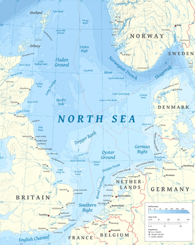
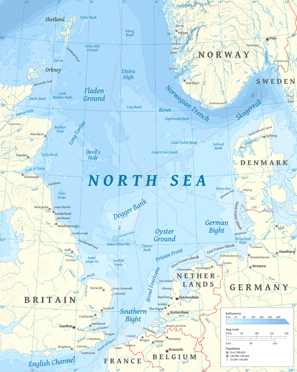
File:North Sea map-en.png
跳至導覽
跳至搜尋

預覽大小:479 × 600 像素。 其他解析度:192 × 240 像素 | 383 × 480 像素 | 613 × 768 像素 | 817 × 1,024 像素 | 2,475 × 3,100 像素。
原始檔案 (2,475 × 3,100 像素,檔案大小:3.8 MB,MIME 類型:image/png)
說明
說明
添加單行說明來描述出檔案所代表的內容
P
摘要
[編輯]
| 描述 | |
| 日期 | |
| 來源 |
自己的作品 using en:GRASS GIS, en:Inkscape and en:GIMP. Data sources:
Map Projection: Universal Transverse Mercator Typeface: Gentium Book Basic from SIL International |
| 作者 | Halava |
| 其他版本 |
  |
授權條款
[編輯]
我,本作品的著作權持有者,決定用以下授權條款發佈本作品:
此檔案採用共享創意 姓名標示-相同方式分享 3.0 未在地化版本授權條款。
- 您可以自由:
- 分享 – 複製、發佈和傳播本作品
- 重新修改 – 創作演繹作品
- 惟需遵照下列條件:
- 姓名標示 – 您必須指名出正確的製作者,和提供授權條款的連結,以及表示是否有對內容上做出變更。您可以用任何合理的方式來行動,但不得以任何方式表明授權條款是對您許可或是由您所使用。
- 相同方式分享 – 如果您利用本素材進行再混合、轉換或創作,您必須基於如同原先的相同或兼容的條款,來分布您的貢獻成品。

|
已授權您依據自由軟體基金會發行的無固定段落、封面文字和封底文字GNU自由文件授權條款1.2版或任意後續版本,對本檔進行複製、傳播和/或修改。該協議的副本列在GNU自由文件授權條款中。 |
您可以選擇您需要的授權條款。
| 註解 | 該圖片含有註解:在維基媒體共享資源上查看註解 |
檔案歷史
點選日期/時間以檢視該時間的檔案版本。
| 日期/時間 | 縮圖 | 尺寸 | 用戶 | 備註 | |
|---|---|---|---|---|---|
| 目前 | 2015年3月5日 (四) 17:23 | | 2,475 × 3,100(3.8 MB) | Tandru7(對話 | 貢獻) | {{Information |Description=Map of the North Sea |Source=Wiki Commons |Date=3/5/15 |Author= |Permission= |other_versions= }} |
| 2010年10月15日 (五) 14:48 |  | 2,475 × 3,100(3.8 MB) | Halava(對話 | 貢獻) | New place names | |
| 2010年10月12日 (二) 17:34 |  | 2,475 × 3,100(3.79 MB) | Halava(對話 | 貢獻) | Some corrections; several new place names | |
| 2010年10月12日 (二) 11:02 |  | 2,475 × 3,100(3.78 MB) | Halava(對話 | 貢獻) | Minor corrections; improved legibility; Horns Rev | |
| 2010年10月10日 (日) 08:09 |  | 2,475 × 3,100(3.72 MB) | Halava(對話 | 貢獻) | Exclusive economic zones; Heligoland | |
| 2010年10月9日 (六) 09:26 |  | 2,475 × 3,100(3.64 MB) | Halava(對話 | 貢獻) | Lindisfarne; Norfolk Banks instead of Wells Bank | |
| 2010年10月8日 (五) 20:27 |  | 2,475 × 3,100(3.63 MB) | Halava(對話 | 貢獻) | Outlined Dogger Bank, fixed a typo | |
| 2010年10月8日 (五) 17:04 |  | 2,475 × 3,100(3.61 MB) | Halava(對話 | 貢獻) | Several improvements | |
| 2010年10月6日 (三) 10:52 |  | 2,475 × 3,100(3.37 MB) | Halava(對話 | 貢獻) | Fixed two typos, switched color model to RGB | |
| 2010年10月6日 (三) 10:09 |  | 2,475 × 3,100(2.57 MB) | Halava(對話 | 貢獻) | {{Information |Description={{en|1=Map of the North Sea.}} |Source={{own}} using GRASS GIS, Inkscape and GIMP. Data sources: * Elevation and bathymetry data from NGDC ETOPO1 * Coastlines, rivers and borders from NGDC World Data Bank II * Cities from OpenS |
無法覆蓋此檔案。
檔案用途
下列10個頁面有用到此檔案:
- North Sea - Nordsee - Noordzee - Nordsøen
- File:Nordsee Wirtschaftszonen.png
- File:North Sea map-de.png
- File:North Sea map-fi.png
- File:North sea eez.PNG
- Category:Lighthouses in the North Sea
- Category:North Sea
- Category:Offshore wind farms in the North Sea
- Category:Raid on Scarborough, Hartlepool and Whitby
- Category:Ships named after the North Sea
全域檔案使用狀況
以下其他 wiki 使用了這個檔案:
- af.wikipedia.org 的使用狀況
- ar.wikipedia.org 的使用狀況
- arz.wikipedia.org 的使用狀況
- ast.wikipedia.org 的使用狀況
- ba.wikipedia.org 的使用狀況
- be-tarask.wikipedia.org 的使用狀況
- bg.wikipedia.org 的使用狀況
- br.wikipedia.org 的使用狀況
- ca.wikipedia.org 的使用狀況
- cs.wikipedia.org 的使用狀況
- cy.wikipedia.org 的使用狀況
- de.wikipedia.org 的使用狀況
- de.wikivoyage.org 的使用狀況
- el.wikipedia.org 的使用狀況
- en.wikipedia.org 的使用狀況
- North Sea
- Skagerrak
- SMS Lützow
- HMS King Edward VII
- HMS Marlborough (1912)
- HMS Emperor of India
- HMS Africa (1905)
- Horns Rev
- HMS Britannia (1904)
- Silverpit crater
- Broad Fourteens
- Dogger Bank
- Long Forties
- HMS Hibernia (1905)
- Fisher Bank
- Norwegian trench
- Silver Pit
- Wikipedia:Userboxes/Location
- Operation Wikinger
- HMS Commonwealth
- Northern Patrol
- Raid on Scarborough, Hartlepool and Whitby
- HMS Hindustan (1903)
- User:Buaidh
- Southern Bight
- History of the North Sea
- First Ostend Raid
檢視此檔案的更多全域使用狀況。