File:North and south pole view of Martian topography.jpg
Salta a la navegació
Salta a la cerca
No hi ha cap versió amb una resolució més gran.
North_and_south_pole_view_of_Martian_topography.jpg (590 × 99 píxels, mida del fitxer: 44 Ko, tipus MIME: image/jpeg)
Llegendes
Llegendes
Afegeix una explicació d'una línia del que representa aquest fitxer
Resum
[modifica]
| Descripció |
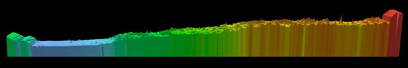
English: Above is a pole-to-pole view of Martian topography from the first MOLA global topographic model [Smith et al., Science, 1999]. The slice runs from the north pole (left) to the south pole (right) along the 0° longitude line. The figure highlights the pole-to-pole slope of 0.036°, such that the south pole has a higher elevation than the north pole by ~6 kilometers. |
| Data | |
| Font | NASA Goddard Space Center MOLA |
| Autor | Responsible NASA Official: Gregory A. Neumann |
Llicència
[modifica]
| Aquest fitxer és en el domini públic perquè ha estat creat per la NASA. L'avís legal de la NASA diu que «el material de la NASA no està protegit per copyright si no es diu el contrari». (NASA copyright policy page o JPL Image Use Policy). | ||
 |
Atenció:
|
Historial del fitxer
Cliqueu una data/hora per veure el fitxer tal com era aleshores.
| Data/hora | Miniatura | Dimensions | Usuari/a | Comentari | |
|---|---|---|---|---|---|
| actual | 03:04, 15 feb 2011 | 590 × 99 (44 Ko) | Steve Quinn (discussió | contribucions) | {{Information |Description ={{en|1=Above is a pole-to-pole view of Martian topography from the first MOLA global topographic model [Smith et al., Science, 1999]. The slice runs from the north pole (left) to the south pole (right) along the 0° longitud |
No podeu sobreescriure aquest fitxer.
Ús del fitxer
No hi ha pàgines que utilitzin aquest fitxer.
Ús global del fitxer
Utilització d'aquest fitxer en altres wikis:
- Utilització a ca.wikipedia.org
- Utilització a en.wikipedia.org
- Utilització a es.wikipedia.org
- Utilització a it.wikipedia.org
- Utilització a zh.wikipedia.org