File:North ossetia map.png
跳转到导航
跳转到搜索
没有更高的分辨率。
North_ossetia_map.png (304 × 377像素,文件大小:23 KB,MIME类型:image/png)
说明
说明
添加一行文字以描述该文件所表现的内容

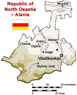
Map of North Ossetia, Russia (from mapping by US Dept of State - 2762 6-94 STATE (INR/GGI))
Originally uploaded to English Wikipedia by ChrisO.
| This image is a work of a United States Department of State employee, taken or made as part of that person's official duties. As a work of the U.S. federal government, the image is in the public domain per 17 U.S.C. § 101 and § 105 and the Department Copyright Information. |  |
文件历史
点击某个日期/时间查看对应时刻的文件。
| 日期/时间 | 缩略图 | 大小 | 用户 | 备注 | |
|---|---|---|---|---|---|
| 当前 | 2005年4月6日 (三) 13:50 | | 304 × 377(23 KB) | Dbenbenn(留言 | 贡献) | Reverted to earlier revision |
| 2005年4月6日 (三) 13:50 |  | 300 × 330(39 KB) | Dbenbenn(留言 | 贡献) | original version, uploaded by en:User:ChrisO at 12:19, 1 Sep 2004 | |
| 2005年3月29日 (二) 12:51 |  | 304 × 377(23 KB) | Fbd~commonswiki(留言 | 贡献) | Image from the en.wikipedia. {{PD-USGov}} |
您不可以覆盖此文件。
文件用途
以下7个页面使用本文件:
全域文件用途
以下其他wiki使用此文件:
- ar.wikipedia.org上的用途
- bn.wikipedia.org上的用途
- ceb.wikipedia.org上的用途
- cy.wikipedia.org上的用途
- da.wikipedia.org上的用途
- de.wikipedia.org上的用途
- en.wikinews.org上的用途
- es.wikipedia.org上的用途
- fa.wikipedia.org上的用途
- fr.wikipedia.org上的用途
- he.wikipedia.org上的用途
- hi.wikipedia.org上的用途
- hr.wikipedia.org上的用途
- id.wikipedia.org上的用途
- io.wikipedia.org上的用途
- is.wikipedia.org上的用途
- it.wikipedia.org上的用途
- ja.wikipedia.org上的用途
- jv.wikipedia.org上的用途
- ka.wiktionary.org上的用途
- ko.wikipedia.org上的用途
- mk.wikipedia.org上的用途
- nl.wikipedia.org上的用途
- nn.wikipedia.org上的用途
- no.wikipedia.org上的用途
- pt.wikipedia.org上的用途
- sh.wikipedia.org上的用途
- sr.wikipedia.org上的用途
- tr.wikipedia.org上的用途
- vep.wikipedia.org上的用途
- zh-min-nan.wikipedia.org上的用途
查看此文件的更多全域用途。