File:Northern Philippines (Luzon).jpg

Orihinal na file (2,000 × 2,600 na pixel, laki: 738 KB, uri ng MIME: image/jpeg)
Captions
Captions
   *
     Credit
     Jacques Descloitres, MODIS Land Rapid Response Team, NASA/GSFC
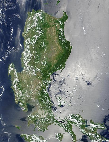
This MODIS true-color image of the northern Philippines shows the island of Luzon and the Cagayan River running in the plains between the Sierra Madre mountain range on the northeast Coast, and the Zambales Mountains to the west. The light-colored, three-pronged shape about 1/4 of the way up from the bottom center of the image is a lagoon to the east of Manila Bay, home of the capital city of the Philippines.
http://visibleearth.nasa.gov/view_rec.php?id=2128
| Public domainPublic domainfalsefalse |
| This file is in the public domain in the United States because it was solely created by NASA. NASA copyright policy states that "NASA material is not protected by copyright unless noted". (See Template:PD-USGov, NASA copyright policy page or JPL Image Use Policy.) |  | |
 |
Warnings:
|
Nakaraan ng file
Pindutin ang isang petsa/oras para makita ang file noong puntong yon.
| Petsa/Oras | Thumbnail | Sukat | Tagagamit | Komento | |
|---|---|---|---|---|---|
| ngayon | 21:52, 25 Oktubre 2005 |  | 2,000 × 2,600 (738 KB) | Brian0918 (usapan | ambag) | * Credit Jacques Descloitres, MODIS Land Rapid Response Team, NASA/GSFC This MODIS true-color image of the northern Philippines shows the island of Luzon and the Cagayan River running in the plains between the Sierra Madre mountain rang |
Hindi mo mao-overwrite ang file na ito.
Paggamit sa file
Ginagamit ng sumusunod na pahina ang file na ito:
Pandaigdigang paggamit sa file
Ginagamit ng mga sumusunod na wiki ang file na ito:
- Paggamit sa af.wikipedia.org
- Paggamit sa ar.wikipedia.org
- Paggamit sa arz.wikipedia.org
- Paggamit sa ast.wikipedia.org
- Paggamit sa ba.wikipedia.org
- Paggamit sa be-tarask.wikipedia.org
- Paggamit sa be.wikipedia.org
- Paggamit sa bg.wikipedia.org
- Paggamit sa bjn.wikipedia.org
- Paggamit sa bo.wikipedia.org
- Paggamit sa ca.wikipedia.org
- Paggamit sa cy.wikipedia.org
- Paggamit sa de.wikipedia.org
- Paggamit sa el.wikipedia.org
- Paggamit sa en.wikipedia.org
- Paggamit sa eo.wikipedia.org
- Paggamit sa es.wikipedia.org
- Paggamit sa et.wikipedia.org
- Paggamit sa eu.wikipedia.org
- Paggamit sa fa.wikipedia.org
- Paggamit sa fi.wiktionary.org
- Paggamit sa fr.wikipedia.org
- Paggamit sa fr.wikivoyage.org
- Paggamit sa ga.wikipedia.org
- Paggamit sa he.wikipedia.org
- Paggamit sa hu.wikipedia.org
- Paggamit sa hy.wikipedia.org
- Paggamit sa ia.wikipedia.org
- Paggamit sa id.wikipedia.org
- Paggamit sa id.wiktionary.org
- Paggamit sa incubator.wikimedia.org
- Paggamit sa jv.wikipedia.org
- Paggamit sa ka.wikipedia.org
- Paggamit sa ky.wikipedia.org
- Paggamit sa lv.wikipedia.org
- Paggamit sa ms.wikipedia.org
- Paggamit sa nn.wikipedia.org
- Paggamit sa os.wikipedia.org
- Paggamit sa pl.wikipedia.org
Tingnan ang karagdagang pandaigdigang paggamit sa file na ito.
Metadata
Naglalaman ang file na ito bg karagdagang impormasyon na posibleng dinagdag mula sa digita na kameta o sa scanner na ginamit o nag-digitize dito. Kung nabago ang file mula sa orihinal na estado nito, posibleng hindi maipakita ang ilang mga detalye sa nabagong file.
| _error | 0 |
|---|