File:Northern Philippines (Luzon).jpg
来自Wikimedia Commons
跳转到导航
跳转到搜索

本预览的尺寸:461 × 599像素。 其他分辨率:184 × 240像素 | 369 × 480像素 | 591 × 768像素 | 788 × 1,024像素 | 2,000 × 2,600像素。
原始文件 (2,000 × 2,600像素,文件大小:738 KB,MIME类型:image/jpeg)
文件信息
结构化数据
说明
说明
添加一行文字以描述该文件所表现的内容
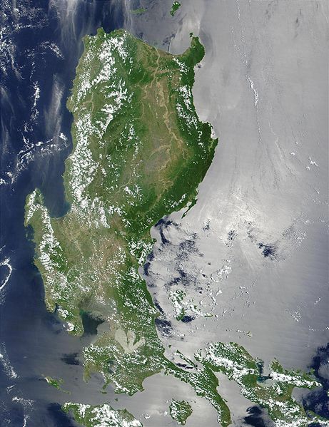
The Island of Luzon(Excluding:Bicol Region,Southernmost part of Mindoro and Palawan
   *
     Credit
     Jacques Descloitres, MODIS Land Rapid Response Team, NASA/GSFC
This MODIS true-color image of the northern Philippines shows the island of Luzon and the Cagayan River running in the plains between the Sierra Madre mountain range on the northeast Coast, and the Zambales Mountains to the west. The light-colored, three-pronged shape about 1/4 of the way up from the bottom center of the image is a lagoon to the east of Manila Bay, home of the capital city of the Philippines.
http://visibleearth.nasa.gov/view_rec.php?id=2128
| Public domainPublic domainfalsefalse |
| 本文件完全由NASA创作,在美国属于公有领域。根据NASA的版权方针,NASA的材料除非另有声明否则不受版权保护。(参见Template:PD-USGov/zh、NASA版权方针页面或JPL图片使用方针。) |  | |
 |
警告:
|
文件历史
点击某个日期/时间查看对应时刻的文件。
| 日期/时间 | 缩略图 | 大小 | 用户 | 备注 | |
|---|---|---|---|---|---|
| 当前 | 2005年10月25日 (二) 21:52 |  | 2,000 × 2,600(738 KB) | Brian0918(留言 | 贡献) | * Credit Jacques Descloitres, MODIS Land Rapid Response Team, NASA/GSFC This MODIS true-color image of the northern Philippines shows the island of Luzon and the Cagayan River running in the plains between the Sierra Madre mountain rang |
您不可以覆盖此文件。
文件用途
全域文件用途
以下其他wiki使用此文件:
- af.wikipedia.org上的用途
- ar.wikipedia.org上的用途
- arz.wikipedia.org上的用途
- ast.wikipedia.org上的用途
- ba.wikipedia.org上的用途
- be-tarask.wikipedia.org上的用途
- be.wikipedia.org上的用途
- bg.wikipedia.org上的用途
- bjn.wikipedia.org上的用途
- bo.wikipedia.org上的用途
- ca.wikipedia.org上的用途
- cy.wikipedia.org上的用途
- de.wikipedia.org上的用途
- el.wikipedia.org上的用途
- en.wikipedia.org上的用途
- eo.wikipedia.org上的用途
- es.wikipedia.org上的用途
- et.wikipedia.org上的用途
- eu.wikipedia.org上的用途
- fa.wikipedia.org上的用途
- fi.wiktionary.org上的用途
- fr.wikipedia.org上的用途
- fr.wikivoyage.org上的用途
- ga.wikipedia.org上的用途
- he.wikipedia.org上的用途
- hu.wikipedia.org上的用途
- hy.wikipedia.org上的用途
- ia.wikipedia.org上的用途
- id.wikipedia.org上的用途
- id.wiktionary.org上的用途
- incubator.wikimedia.org上的用途
- jv.wikipedia.org上的用途
- ka.wikipedia.org上的用途
- ky.wikipedia.org上的用途
- lv.wikipedia.org上的用途
- ms.wikipedia.org上的用途
- nn.wikipedia.org上的用途
- os.wikipedia.org上的用途
- pl.wikipedia.org上的用途
查看此文件的更多全域用途。
元数据
此文件含有额外信息,这些信息可能是创建或数字化该文件时使用的数码相机或扫描仪所添加的。如果文件已从其原始状态修改,某些详细信息可能无法完全反映修改后的文件。
| _error | 0 |
|---|