File:Nouveau plan de Gibraltar - Jean Covens et Corneille Mortier.jpg

Archivo original (1276 × 1107 píxeles; tamaño de archivo: 759 kB; tipo MIME: image/jpeg)
Leyendas
Leyendas
Resumen[editar]
| Descripción |
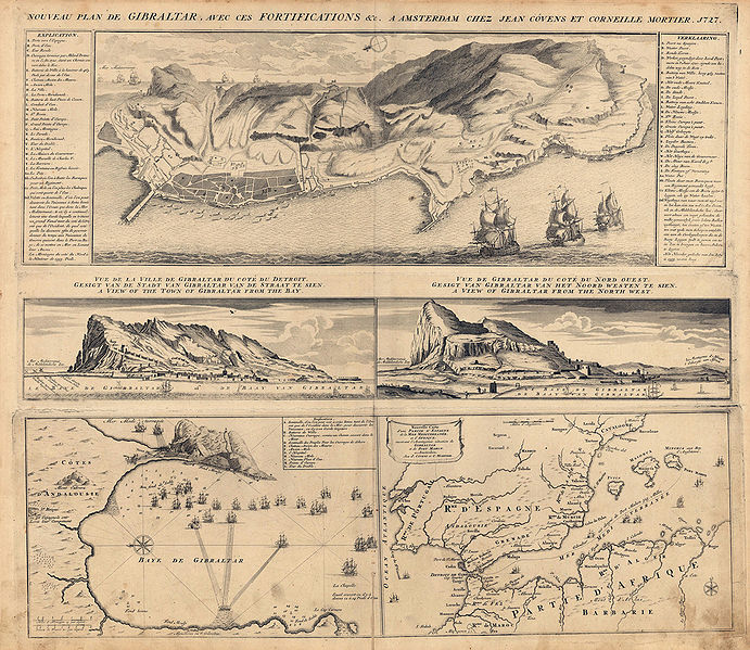
English: Map showing a plan of Gibraltar with its fortifications. It includes an explanation in the upper right and left corner. In the centre of the map there are two views of Gibraltar. At the bottom there is an inset map showing the Southern Iberian Peninsula and the North African coast. The other inset map at the bottom shows the bay of Gibraltar. |
| Fecha | hacia 1727 |
| Fuente | Antique Maps of Spain |
| Autor | Jean Covens and Corneille Mortier |
Licencia[editar]
|
Esta es una reproducción fotográfica fiel de una obra de arte bidimensional de dominio público. La obra de arte misma se halla en el dominio público por el motivo siguiente:
La postura oficial de la Fundación Wikimedia considera que «las reproducciones fieles de obras de arte bidimensionales de dominio público forman parte del dominio público». Esta reproducción fotográfica, por ende, también se considera de dominio público dentro de los Estados Unidos. Es posible que otras jurisdicciones restrinjan la reutilización de este contenido; consúltese Reutilización de fotografías PD-Art (en inglés) para más detalles. {{PD-Art}} template without license parameter: please specify why the underlying work is public domain in both the source country and the United States
(Usage: {{PD-Art|1=|deathyear=''year of author's death''|country=''source country''}}, where parameter 1= can be PD-old-auto, PD-old-auto-expired, PD-old-auto-1996, PD-old-100 or similar. See Commons:Multi-license copyright tags for more information.) | ||||
Historial del archivo
Haz clic sobre una fecha y hora para ver el archivo tal como apareció en ese momento.
| Fecha y hora | Miniatura | Dimensiones | Usuario | Comentario | |
|---|---|---|---|---|---|
| actual | 21:54 26 feb 2010 | | 1276 × 1107 (759 kB) | Ecemaml (discusión | contribs.) | {{Information |Description={{en|1=Map showing a plan of Gibraltar with its fortifications. It includes an explanation in the upper right and left corner. In the centre of the map there are two views of Gibraltar. At the bottom there is an inset map showin |
No puedes sobrescribir este archivo.
Usos del archivo
No hay páginas que enlacen a este archivo.
Uso global del archivo
Las wikis siguientes utilizan este archivo:
- Uso en en.wikipedia.org
- Uso en es.wikipedia.org