File:Obcine Slovenija 2006 Semic.svg
跳至導覽
跳至搜尋

此 SVG 檔案的 PNG 預覽的大小:800 × 522 像素。 其他解析度:320 × 209 像素 | 640 × 418 像素 | 1,024 × 668 像素 | 1,280 × 835 像素 | 2,560 × 1,670 像素 | 2,613 × 1,705 像素。
原始檔案 (SVG 檔案,表面大小:2,613 × 1,705 像素,檔案大小:2.36 MB)
說明
說明
添加單行說明來描述出檔案所代表的內容
摘要
[編輯]
| 描述 |
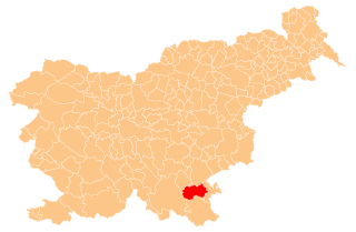
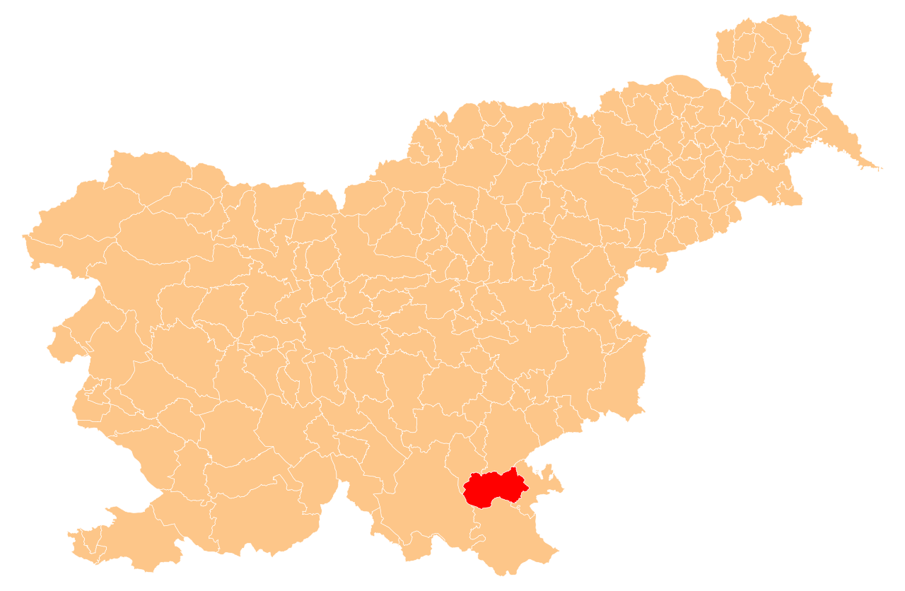
English: Občina Semič (marked red) on map of the municipalities (občine) of the Republic of Slovenia, as since May 2006 (210 units). |
| 日期 | |
| 來源 | Manipulated Image:Obcine Slovenija 2006.svg in text editor. |
| 作者 | Source of the public data is GURS (Geodetska uprava Republike Slovenije or Surveying and Mapping Authority of the Republic of Slovenia). Converted from Shapefile to SVG with shp2svg and prepared for Wikipedia by romanm (talk). |
| 授權許可 (重用此檔案) |
Public domain. See Image:Obcine Slovenija 2006.svg for an explanation. |
授權條款
[編輯]
| 我,此作品的版權所有人,釋出此作品至公共領域。此授權條款在全世界均適用。 這可能在某些國家不合法,如果是的話: 我授予任何人有權利使用此作品於任何用途,除受法律約束外,不受任何限制。 |
檔案歷史
點選日期/時間以檢視該時間的檔案版本。
| 日期/時間 | 縮圖 | 尺寸 | 使用者 | 備註 | |
|---|---|---|---|---|---|
| 目前 | 2009年7月7日 (二) 20:08 | | 2,613 × 1,705(2.36 MB) | Romanm(留言 | 貢獻) | {{Information |Description={{en|1=''Občina Semič'' (marked red) on map of the municipalities (''občine'') of the Republic of Slovenia, as since May 2006 (210 units).}} |Source=Manipulated Image:Obcine Slovenija 2006.svg in text editor. |Author=Sou |
無法覆蓋此檔案。
檔案用途
下列2個頁面有用到此檔案:
全域檔案使用狀況
以下其他 wiki 使用了這個檔案:
- ceb.wikipedia.org 的使用狀況
- de.wikipedia.org 的使用狀況
- en.wikipedia.org 的使用狀況
- Semič
- Template:Semič
- John Stariha
- Blatnik pri Črmošnjicah
- Štrekljevec
- Brezje pri Rožnem Dolu
- Brezje pri Vinjem Vrhu
- Brezova Reber
- Brezovica pri Črmošnjicah
- Brstovec
- Cerovec pri Črešnjevcu
- Črešnjevec pri Semiču
- Črmošnjice, Semič
- Gornje Laze
- Gradnik
- Hrib pri Cerovcu
- Hrib pri Rožnem Dolu
- Kal, Semič
- Komarna Vas
- Krupa, Semič
- Krvavčji Vrh
- Lipovec, Semič
- Maline pri Štrekljevcu
- Moverna Vas
- Nestoplja Vas
- Omota
- Oskoršnica
- Osojnik, Semič
- Planina, Semič
- Podreber, Semič
- Potoki, Semič
- Praproče, Semič
- Praprot
- Preloge, Semič
- Pribišje
- Pugled, Semič
- Rožni Dol
- Sela pri Vrčicah
- Sodji Vrh
- Sredgora
- Srednja Vas, Semič
- Starihov Vrh
- Stranska Vas pri Semiču
- Trebnji Vrh
- Vinji Vrh pri Semiču
- Vrčice
檢視此檔案的更多全域使用狀況。