File:Obcine Slovenija 2007 Ajdovscina.svg
Salta a la navegació
Salta a la cerca

Mida d'aquesta previsualització PNG del fitxer SVG: 800 × 522 píxels. Altres resolucions: 320 × 209 píxels | 640 × 418 píxels | 1.024 × 668 píxels | 1.280 × 835 píxels | 2.560 × 1.670 píxels | 2.613 × 1.705 píxels.
Fitxer original (fitxer SVG, nominalment 2.613 × 1.705 píxels, mida del fitxer: 2,36 Mo)
Llegendes
Llegendes
Afegeix una explicació d'una línia del que representa aquest fitxer
Resum
[modifica]
| Descripció |
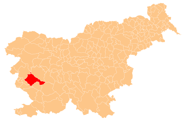
English: Občina Ajdovščina (marked red) on map of the municipalities (občine) of the Republic of Slovenia, as since May 2006 (210 units). |
| Data | |
| Font | Manipulated Image:Obcine Slovenija 2006.svg in text editor. |
| Autor | Source of the public data is GURS (Geodetska uprava Republike Slovenije or Surveying and Mapping Authority of the Republic of Slovenia). Converted from Shapefile to SVG with shp2svg and prepared for Wikipedia by romanm (talk). |
| Permís (Com reutilitzar aquest fitxer) |
Public domain. See Image:Obcine Slovenija 2006.svg for an explanation. |
Llicència
[modifica]
| Jo, el titular del copyright d'aquesta obra, l'allibero al domini públic. Això s'aplica a tot el món. En alguns països això pot no ser legalment possible, en tal cas: Jo faig concessió a tothom del dret d'usar aquesta obra per a qualsevol propòsit, sense cap condició llevat d'aquelles requerides per la llei. |
Historial del fitxer
Cliqueu una data/hora per veure el fitxer tal com era aleshores.
| Data/hora | Miniatura | Dimensions | Usuari/a | Comentari | |
|---|---|---|---|---|---|
| actual | 21:04, 8 nov 2009 | | 2.613 × 1.705 (2,36 Mo) | Romanm (discussió | contribucions) | correct version - previous was invalid |
| 20:59, 8 nov 2009 |  | 2.613 × 1.705 (621 Ko) | Romanm (discussió | contribucions) | {{Information |Description={{en|1=''Občina Ajdovščina'' (marked red) on map of the municipalities (''občine'') of the Republic of Slovenia, as since May 2006 (210 units).}} |Source=Manipulated Image:Obcine Slovenija 2006.svg in text editor. |Auth |
No podeu sobreescriure aquest fitxer.
Ús del fitxer
La pàgina següent utilitza aquest fitxer:
Ús global del fitxer
Utilització d'aquest fitxer en altres wikis:
- Utilització a bg.wikipedia.org
- Шаблон:Община Айдовшчина
- Батуе
- Бела (община Айдовшчина)
- Бре (Словения)
- Айдовшчина
- Будане
- Велике Жабле
- Випавски Криж
- Вишне (община Айдовшчина)
- Водице (община Айдовшчина)
- Врътовче
- Врътовин
- Габере (община Айдовшчина)
- Гозд (община Айдовшчина)
- Гояче
- Гривче
- Добравле (община Айдовшчина)
- Долга Поляна
- Долене (община Айдовшчина)
- Завино
- Жаголич
- Жапуже
- Камне (община Айдовшчина)
- Ковк (община Айдовшчина)
- Кожмани
- Крижна гора (община Айдовшчина)
- Локавец (община Айдовшчина)
- Мале Жабле
- Мало Поле
- Маловше
- Отлица
- Планина (община Айдовшчина)
- Плаче
- Подкрай (община Айдовшчина)
- Поточе (община Айдовшчина)
- Предмея
- Равне (община Айдовшчина)
- Село (община Айдовшчина)
- Скриле
- Стомаж (община Айдовшчина)
- Тевче (община Айдовшчина)
- Усте
- Цеста (община Айдовшчина)
- Цол (селище)
- Чърнице
- Шмаре (община Айдовшчина)
- Айдовшчина (община)
- Utilització a ca.wikipedia.org
- Utilització a en.wikipedia.org
Vegeu més usos globals d'aquest fitxer.