File:Oberschlesien 1921.png
Skočit na navigaci
Skočit na vyhledávání
Větší rozlišení není k dispozici.
Oberschlesien_1921.png (411 × 323 pixelů, velikost souboru: 13 KB, MIME typ: image/png)
Popisky
Popisky
Přidejte jednořádkové vysvětlení, co tento soubor představuje
Popis[editovat]
| Popis |
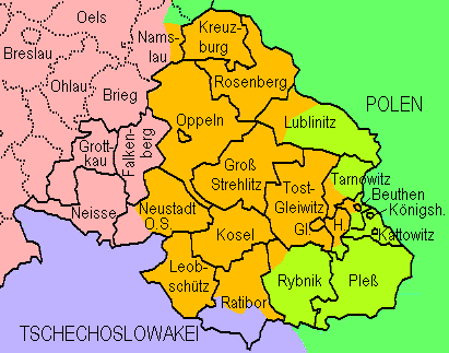
English: Upper Silesia plebiscite 1921: Lined borders = the German border of 1918 and districts of upper Silesia; dotted = Districts of lower Silesia; lilac = Czechoslovakia inclusive territories received from Germany without plebiscite; green = Poland; yellowish green = transferred to Poland after the plebiscite; orange = remaining in Germany after the plebiscite
Deutsch: Volksabstimmung in Oberschlesien 1921: Durchgezogene Grenzen = Reichsgrenze von 1918 und oberschlesische Kreise; gepunktete Grenzen = niederschlesische Kreise. Lila = Tschechoslowakei einschl. von Deutschland erhaltenem Gebiet; grün = Polen; gelbgrün = aufgrund der Abstimmung an Polen gekommenes Gebiet; orange = aufgrund der Abstimmung bei Deutschland gebliebenes Gebiet. Die Markierung der Teilungsgrenze(n) erfolgte anhand Westermanns Monatshefte-Atlas (ca. 1960, "aktuelle" Karte in der damals üblichen retro-Darstellung). Die Darstellung von Kreisen, die nur teilweise zum Abstimmungegebiet gehörten, erfolgte anhand in Berichten genannter Ortsnamen. |
| Datum | |
| Zdroj | Vlastní dílo, redrawn from http://www.gemeindeverzeichnis.de/gem1900/gem1900.htm?gem1900_2.htm , where it is no more available |
| Autor | Ulamm |
Licence[editovat]
Já, držitel autorských práv k tomuto dílu, ho tímto zveřejňuji za podmínek následující licence:
Tento soubor podléhá licenci Creative Commons Uveďte autora 3.0 Unported
- Dílo smíte:
- šířit – kopírovat, distribuovat a sdělovat veřejnosti
- upravovat – pozměňovat, doplňovat, využívat celé nebo částečně v jiných dílech
- Za těchto podmínek:
- uveďte autora – Máte povinnost uvést autorství, poskytnout odkaz na licenci a uvést, pokud jste provedli změny. Toho můžete docílit jakýmkoli rozumným způsobem, avšak ne způsobem naznačujícím, že by poskytovatel licence schvaloval nebo podporoval vás nebo vaše užití díla.
Historie souboru
Kliknutím na datum a čas se zobrazí tehdejší verze souboru.
| Datum a čas | Náhled | Rozměry | Uživatel | Komentář | |
|---|---|---|---|---|---|
| současná | 7. 8. 2009, 14:18 | | 411 × 323 (13 KB) | Ulamm (diskuse | příspěvky) | Division of Kreis Lublinitz |
| 12. 9. 2008, 22:16 |  | 411 × 323 (13 KB) | Ulamm (diskuse | příspěvky) | {{Information |Description= |Source= |Date= |Author= |Permission= |other_versions= }} | |
| 12. 9. 2008, 20:39 |  | 411 × 330 (13 KB) | Ulamm (diskuse | příspěvky) | {{Information |Description={{en|1=Upper Silesia plebiscite 1921: Lined borders = the German border of 1918 and districts of upper Silesia; dotted = Districts of lower Silesia; lilac = Czechoslovakia inclusive territories received from Germany without pleb |
Tento soubor nemůžete přepsat.
Využití souboru
Na Commons na soubor odkazuje tato stránka:
Globální využití souboru
Tento soubor využívají následující wiki:
- Využití na ar.wikipedia.org
- Využití na cs.wikipedia.org
- Využití na de.wikipedia.org
- Využití na el.wikipedia.org
- Využití na en.wikipedia.org
- Využití na fi.wikipedia.org
- Využití na fr.wikipedia.org
- Využití na hu.wikipedia.org
- Využití na id.wikipedia.org
- Využití na incubator.wikimedia.org
- Využití na it.wikipedia.org
- Využití na nl.wikipedia.org
- Využití na pl.wikipedia.org
- Využití na ru.wikipedia.org
- Využití na th.wikipedia.org
- Využití na tr.wikipedia.org
- Využití na zh.wikipedia.org