File:Oceanic gyres.png
跳转到导航
跳转到搜索

本预览的尺寸:800 × 523像素。 其他分辨率:320 × 209像素 | 640 × 418像素 | 1,024 × 669像素 | 1,280 × 836像素 | 1,875 × 1,225像素。
原始文件 (1,875 × 1,225像素,文件大小:328 KB,MIME类型:image/png)
说明
说明
添加一行文字以描述该文件所表现的内容
摘要
[编辑]
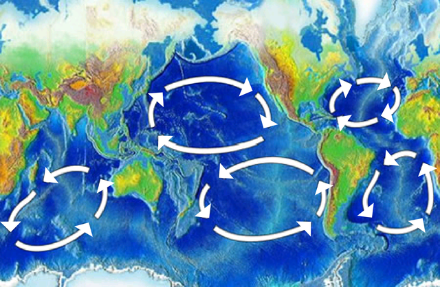
| 描述 | There are five major ocean-wide gyres — the North Atlantic, South Atlantic, North Pacific, South Pacific, and Indian Ocean gyres. Each is flanked by a strong and narrow “western boundary current,” and a weak and broad “eastern boundary current”. |
| 日期 | |
| 来源 | here, img |
| 作者 | NOAA |
| 其他版本 | Image:Pacific oceanic gyres.png |
许可协议
[编辑]
本图像属于公有领域,因该作品最初来自于美国国家海洋和大气管理局职员的职务作品。
|
文件历史
点击某个日期/时间查看对应时刻的文件。
| 日期/时间 | 缩略图 | 大小 | 用户 | 备注 | |
|---|---|---|---|---|---|
| 当前 | 2024年8月16日 (五) 15:24 | | 1,875 × 1,225(328 KB) | Belbury(留言 | 贡献) | Reverted to version as of 21:46, 12 December 2018 (UTC) seems okay under COM:OVERWRITE, "essential composition is not altered" |
| 2024年5月20日 (一) 06:18 |  | 450 × 294(225 KB) | Sumanjyot840(留言 | 贡献) | Reverted to version as of 02:47, 5 April 2008 (UTC) | |
| 2018年12月12日 (三) 21:46 |  | 1,875 × 1,225(328 KB) | A loose necktie(留言 | 贡献) | Fixing surprisingly unhelopful NOAA map by adding better arrows | |
| 2008年4月5日 (六) 02:47 |  | 450 × 294(225 KB) | Jrockley(留言 | 贡献) | {{Information |Description=Gyres of the world's oceans |Source=[http://oceanservice.noaa.gov/education/kits/currents/05currents3.html here] |Date=March 25, 2008 |Author=NOAA |Permission= |other_versions= }} Category:Oceans [[Category:Mar |
您不可以覆盖此文件。
文件用途
没有页面使用本文件。
全域文件用途
以下其他wiki使用此文件:
- af.wikipedia.org上的用途
- ar.wikipedia.org上的用途
- bn.wikipedia.org上的用途
- bs.wikipedia.org上的用途
- ca.wikipedia.org上的用途
- da.wikipedia.org上的用途
- de.wikipedia.org上的用途
- de.wikinews.org上的用途
- en.wikipedia.org上的用途
- Atlantic Ocean
- History of Portugal (1415–1578)
- Downwelling
- Conquistador
- Ocean gyre
- Kuroshio Current
- Walter Munk
- Great Pacific garbage patch
- Volta do mar
- User:Epipelagic/sandbox/box3
- Wild fisheries
- Ocean
- Indian Ocean Gyre
- Indian Ocean garbage patch
- Marine habitat
- User:GarrettGissinger/sandbox
- User:Daniel Mietchen/gallery
- Beach cleaning
- Template:Oceanic gyres
- Low-nutrient, low-chlorophyll region
查看此文件的更多全域用途。