File:Oceanic pole of inaccessibility.png
Naviqasiyaya keç
Axtarışa keç

Sınaq göstərişi ölçüsü: 600 × 600 piksel. Digər ölçülər: 240 × 240 piksel | 480 × 480 piksel | 960 × 960 piksel.
Faylın orijinalı (960 × 960 piksel, fayl həcmi: 63 KB, MIME növü: image/png)
Captions
Captions
Add a one-line explanation of what this file represents
Xülasə[redaktə]

|
This map image could be re-created using vector graphics as an SVG file. This has several advantages; see Commons:Media for cleanup for more information. If an SVG form of this image is available, please upload it and afterwards replace this template with
{{vector version available|new image name}}.
It is recommended to name the SVG file “Oceanic pole of inaccessibility.svg”—then the template Vector version available (or Vva) does not need the new image name parameter. |
| İzah |
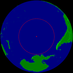
English: Spherical Earth centered on the oceanic pole of inaccessibility in the Southern Pacific ocean. The circle indicates the distance to the nearest landmasses (Antarctica, Easter Island and Ducie Island). The circle is deliberately a bit too small to ensure that the islands are still visible.
Deutsch: Erdkugel, zentriert auf dem ozeanischen Pol der Unzugänglichkeit im südlichen Pazifik. Der Kreis zeigt den Abstand zu den nächstgelegenen Landmassen (Antarktis, Osterinsel und Ducie). Der Kreis ist absichtlich ein wenig zu klein, damit die Inseln nicht verdeckt werden. |
| Tarix | |
| Mənbə | Öz işi |
| Müəllif | Timwi |
| İcazə (Faylın təkrar istifadəsi) |
Public domain |
Lisenziya[redaktə]
| Mən, bu əsərin müəllif hüquqlarının sahibi kimi, əsəri ictimai mülkiyyətə verirəm. Bu icazə bütün dünyada qüvvədədir. In some countries this may not be legally possible; if so: Bunun qanunla mümkün olmadığı hallarda: İstənilən şəxsə, istənilən məqsəd üçün, qanunlar tərəfindən qadağan edilməyincə, heç bir şərt qoymadan bu işdən istifadə haqqını bağışlayıram. |
Faylın tarixçəsi
Faylın əvvəlki versiyasını görmək üçün gün/tarix bölməsindəki tarixlərə klikləyin.
| Tarix/Vaxt | Kiçik şəkil | Ölçülər | İstifadəçi | Şərh | |
|---|---|---|---|---|---|
| indiki | 10:21, 24 mart 2015 | | 960 × 960 (63 KB) | RokerHRO (müzakirə | töhfələr) | optipng -o7 -i0 → 28.12% decrease |
| 23:40, 25 iyul 2008 |  | 960 × 960 (88 KB) | Timwi (müzakirə | töhfələr) | {{Information |Description= |Source= |Date= |Author= |Permission= |other_versions= }} | |
| 23:14, 25 iyul 2008 |  | 952 × 952 (38 KB) | Timwi (müzakirə | töhfələr) | {{Information |Description={{en|1=Spherical Earth centered on the oceanic en:pole of inaccessibility in the Southern Pacific ocean. The circle indicates the distance to the nearest landmasses (en:Antarctica, en:Easter Island and [[en:Ducie |
Siz bu faylı yenidən yükləyə bilməzsiniz.
Fayl keçidləri
Aşağıdakı səhifə bu faylı istifadə edir:
Faylın qlobal istifadəsi
Bu fayl aşağıdakı vikilərdə istifadə olunur:
- ar.wikipedia.org layihəsində istifadəsi
- ast.wikipedia.org layihəsində istifadəsi
- az.wikipedia.org layihəsində istifadəsi
- ca.wikipedia.org layihəsində istifadəsi
- de.wikipedia.org layihəsində istifadəsi
- en.wikipedia.org layihəsində istifadəsi
- en.wikivoyage.org layihəsində istifadəsi
- es.wikipedia.org layihəsində istifadəsi
- et.wikipedia.org layihəsində istifadəsi
- eu.wikipedia.org layihəsində istifadəsi
- fa.wikipedia.org layihəsində istifadəsi
- frr.wikipedia.org layihəsində istifadəsi
- fr.wikipedia.org layihəsində istifadəsi
- fr.wiktionary.org layihəsində istifadəsi
- he.wikipedia.org layihəsində istifadəsi
- hu.wikipedia.org layihəsində istifadəsi
- id.wikipedia.org layihəsində istifadəsi
- it.wikipedia.org layihəsində istifadəsi
- ja.wikipedia.org layihəsində istifadəsi
- lb.wikipedia.org layihəsində istifadəsi
- lt.wikipedia.org layihəsində istifadəsi
- nl.wikipedia.org layihəsində istifadəsi
- nn.wikipedia.org layihəsində istifadəsi
- no.wikipedia.org layihəsində istifadəsi
- pl.wikipedia.org layihəsində istifadəsi
- pt.wikipedia.org layihəsində istifadəsi
- ro.wikipedia.org layihəsində istifadəsi
- sk.wikipedia.org layihəsində istifadəsi
- tr.wikipedia.org layihəsində istifadəsi
- uk.wikipedia.org layihəsində istifadəsi
- vi.wikipedia.org layihəsində istifadəsi
- www.wikidata.org layihəsində istifadəsi
- zh-classical.wikipedia.org layihəsində istifadəsi
Bu faylın qlobal istifadəsinə baxın.