File:Oder-Neisse line between Germany and Poland.jpg
跳去導覽
跳去搵嘢
預覽大細:674 × 599 像素。 第啲解像度:270 × 240 像素 | 540 × 480 像素 | 785 × 698 像素。
原本檔案 (785 × 698 像素,檔案大細:102 KB ,MIME類型:image/jpeg)
Captions
Captions
Add a one-line explanation of what this file represents

|
This historical map image could be recreated using vector graphics as an SVG file. This has several advantages; see Commons:Media for cleanup for more information. If an SVG form of this image is already available, please upload it. After uploading an SVG, replace this template with {{vector version available|new image name.svg}}.
|


摘要[編輯]
| 描述 |
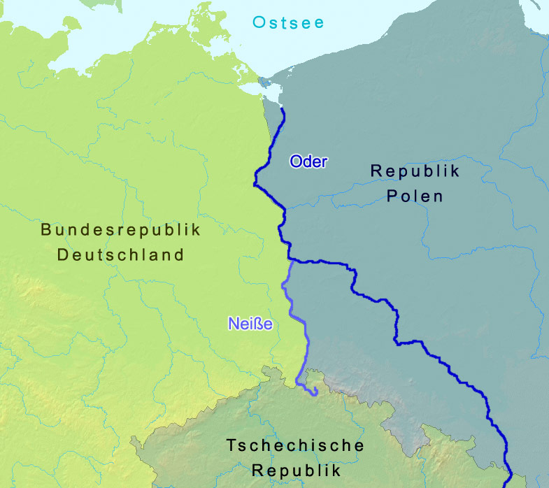
English: The named rivers are the border of Germany and Poland: the Oder-Neisse line, save at the north end it is shifted slightly west to include the Polish city Szczecin and Polish-speaking villages. The countries are named in German. Czechia in its national tongue is Česko. Poland, in its, is Polska. The Baltic Sea is, in Polish,
morze Bałtyckie.
Deutsch: Grenze zwischen Polen und Deutschland entlang der Oder-Neiße-Grenze |
| 日期 | |
| 來源 | A map from demis.nl |
| 作者 | Christoph Lingg |
| 許可 (重用呢個檔案) |
cc-by-sa-2.0-de |
| Uploaded at de.Wikipedia | 2006年3月21號 12:55 |
| Uploaded at Commons | 2006年5月15號 15:18 (UTC) |
協議[編輯]
Ĉi tiu dosiero estas disponebla laŭ la permesilo Krea Komunaĵo Atribuite-Samkondiĉe 2.0 Germanujo.
- 你可以:
- 去分享 – 複製、發佈同傳播呢個作品
- 再改 – 創作演繹作品
- 要遵照下面嘅條件:
- 署名 – 你一定要畀合適嘅表彰、畀返指向呢個授權條款嘅連結,同埋寫明有無改過嚟。你可以用任何合理方式去做,但唔可以用任何方式暗示授權人認可咗你或者你嘅使用方式。
- 相同方式分享 – 如果你用任何方式改過呢個作品,你必須要用返原本或者相似嘅條款發佈。

Original upload log[編輯]
Image history of de:Bild:Oder neisse grenze.jpg:
| Upload date | User | Bytes | Dimensions | Comment |
|---|---|---|---|---|
| 2006-03-21 17:57 | C.lingg | 104,398 | 785×698 | * Bildbeschreibung: Grenzverlauf zwischen Deutschland und Polen in Bezug auf die Oder-Neiße-Grenze * Quelle: Landkarte: demis.nl * Fotograf/Zeichner: Christoph Lingg * Datum: 22.03.2006 * Version: 2, Kontrast der Färbung von Dtl und Polen verstärkt |
| 2006-03-21 12:55 | C.lingg | 112,647 | 785×698 | * Bildbeschreibung: Grenzverlauf zwischen Deutschland und Polen in Bezug auf die Oder-Neiße-Grenze * Quelle: Landkarte: demis.nl * Fotograf/Zeichner: Christoph Lingg * Datum: 22.03.2006 |
檔案歷史
撳個日期/時間去睇響嗰個時間出現過嘅檔案。
| 日期/時間 | 縮圖 | 尺寸 | 用戶 | 註解 | |
|---|---|---|---|---|---|
| 現時 | 2006年6月15號 (四) 15:19 | | 785 × 698(102 KB) | Thuresson(傾偈 | 貢獻) | more contrast |
| 2006年6月15號 (四) 15:18 |  | 785 × 698(110 KB) | Thuresson(傾偈 | 貢獻) |
你無得衾咗個檔案。
檔案用途
以下嘅11版用到呢個檔:
全域檔案使用情況
下面嘅維基都用緊呢個檔案:
- ar.wikipedia.org嘅使用情況
- arz.wikipedia.org嘅使用情況
- azb.wikipedia.org嘅使用情況
- az.wikipedia.org嘅使用情況
- be.wikipedia.org嘅使用情況
- br.wikipedia.org嘅使用情況
- ca.wikipedia.org嘅使用情況
- cs.wikipedia.org嘅使用情況
- cy.wikipedia.org嘅使用情況
- da.wikipedia.org嘅使用情況
- de.wikipedia.org嘅使用情況
- dsb.wikipedia.org嘅使用情況
- el.wikipedia.org嘅使用情況
- en.wikipedia.org嘅使用情況
- eo.wikipedia.org嘅使用情況
- es.wikipedia.org嘅使用情況
- es.wikibooks.org嘅使用情況
- eu.wikipedia.org嘅使用情況
- fa.wikipedia.org嘅使用情況
- fi.wikipedia.org嘅使用情況
- fr.wikipedia.org嘅使用情況
- fy.wikipedia.org嘅使用情況
- ga.wikipedia.org嘅使用情況
- gl.wikipedia.org嘅使用情況
睇呢個檔案嘅更多全域使用情況。