File:Odisha locator map.svg
跳去導覽
跳去搵嘢

呢個「SVG」檔案嘅呢個「PNG」預覽嘅大細:607 × 600 像素。 第啲解像度:243 × 240 像素 | 486 × 480 像素 | 778 × 768 像素 | 1,037 × 1,024 像素 | 2,074 × 2,048 像素 | 2,269 × 2,241 像素。
原本檔案 (SVG檔案,表面大細: 2,269 × 2,241 像素,檔案大細:211 KB)
Captions
Captions
Add a one-line explanation of what this file represents
Odisha
| 標題 |
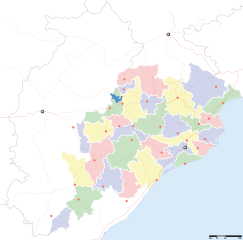
Orissa locator map |
||
| Description |
Locator map for the Indian state of w:Orissa. Equirectangular projection - Geographic limits of the map: top=24.27, bottom=17.691 |
||
| 日期 | |||
| 來源 |
自己作品 |
||
| Creator |
|
||
| 許可 (重用呢個檔案) |
我,呢份作品嘅作者,決定用以下許可發佈呢件作品: 呢個檔案用共享創意 姓名標示-非商業性-相同方式分享3.0 未本地化版本條款授權。
|
||
| Geotemporal data | |||
| Date depicted | second half of 20 century 同埋21 century | ||
| Georeferencing | If inappropriate please set warp_status = skip to hide. | ||
| Archival data | |||
| 註 | Part of WikiProject India Maps | ||
檔案歷史
撳個日期/時間去睇響嗰個時間出現過嘅檔案。
| 日期/時間 | 縮圖 | 尺寸 | 用戶 | 註解 | |
|---|---|---|---|---|---|
| 現時 | 2008年9月6號 (六) 17:28 | | 2,269 × 2,241(211 KB) | Planemad(傾偈 | 貢獻) | |
| 2008年2月21號 (四) 13:28 |  | 647 × 564(132 KB) | Mkeranat~commonswiki(傾偈 | 貢獻) | {{Information |Description=Locator map for the state of [w:Orissa] updated to show white borders for districts |Source=self-made, based on India locator map by [w:User:Planemad] |Date=Feb 2008 |Author= Mkeranat |Permission= |other_versions= }} | |
| 2008年2月14號 (四) 21:32 |  | 647 × 564(130 KB) | Mkeranat~commonswiki(傾偈 | 貢獻) | {{Information |Description=Locator map for the state of [w:Orissa] |Source=self-made, based on India locator map by [w:User:Planemad] |Date=Feb 2008 |Author= Mkeranat |Permission= |other_versions= }} |
你無得衾咗個檔案。
檔案用途
以下嘅10版用到呢個檔:
全域檔案使用情況
下面嘅維基都用緊呢個檔案:
- ar.wikipedia.org嘅使用情況
- as.wikipedia.org嘅使用情況
- awa.wikipedia.org嘅使用情況
- ba.wikipedia.org嘅使用情況
- ceb.wikipedia.org嘅使用情況
- de.wikipedia.org嘅使用情況
- en.wikipedia.org嘅使用情況
- es.wikipedia.org嘅使用情況
- fa.wikipedia.org嘅使用情況
- gu.wikipedia.org嘅使用情況
- hi.wikipedia.org嘅使用情況
- नलबण पक्षी अभयारण्य
- साँचा:ओड़िशा के लोकसभा निर्वाचन क्षेत्र
- आस्का लोक सभा निर्वाचन क्षेत्र
- भुवनेश्वर लोक सभा निर्वाचन क्षेत्र
- बलांगिर लोक सभा निर्वाचन क्षेत्र
- कटक लोक सभा निर्वाचन क्षेत्र
- ढेंकानाल लोक सभा निर्वाचन क्षेत्र
- जगतसिंहपुर लोक सभा निर्वाचन क्षेत्र
- जाजपुर लोक सभा निर्वाचन क्षेत्र
- कलाहांडी लोक सभा निर्वाचन क्षेत्र
- कंधमाल लोक सभा निर्वाचन क्षेत्र
睇呢個檔案嘅更多全域使用情況。