File:Okavango Delta map.png

თავდაპირველი ფაილი (1 860 × 1 916 პიქსელი, ფაილის ზომა: 733 კბ, MIME ტიპი: image/png)
Captions
Captions
| აღწერა |
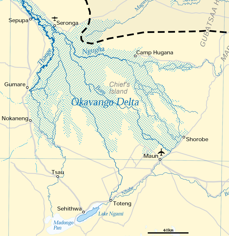
Deutsch: Karte des Okawangodeltas (vergrößerter Ausschnitt aus Datei Okavango River Basin map.png). Detaillierte Kartenlegende siehe dort.
English: Map of the Okavango delta (Botswana), expanded part of File:Okavango River Basin map.png. For detailled map legend see there.
|
| თარიღი | |
| წყარო | http://www.un.org/Depts/Cartographic/map/profile/okavango.pdf (part) |
| ავტორი | United Nations |
| უფლება (ფაილის მეორეული გამოყენება) |
UN map as PD |
| სხვა ვერსიები |
 |
| This image is a map derived from a United Nations map.
Unless stated otherwise, UN maps are to be considered in the public domain. This applies worldwide. UN maps are, in principle, open source material and you can use them in your work or for making your own map. UN requests however that you delete the UN name, logo and reference number upon any modification to the map. Content of your map will be your responsibility. You can state in your publication, if you wish, something like: based on UN map … (map name, map number, revision number and date). See: Geospatial Information Section. And: Geospatial, location data for a better world. |
 |
ფაილის ისტორია
დააწკაპუნეთ თარიღზე/დროზე, რათა იხილოთ ფაილი, როგორც ის მაშინ გამოიყურებოდა.
| თარიღი/დრო | მინიატიურა | განზომილებები | მომხმარებელი | კომენტარი | |
|---|---|---|---|---|---|
| მიმდინარე | 17:54, 27 ივნისი 2018 | | 1 860 × 1 916 (733 კბ) | Antonsusi (განხილვა | წვლილი) | adding a scale |
| 06:45, 5 აპრილი 2016 |  | 1 860 × 1 916 (427 კბ) | RokerHRO (განხილვა | წვლილი) | optipng -zc1-9 -zm1-9 -zs0-3 -f0-5 -i0 → 41.70% decrease | |
| 12:55, 17 მარტი 2012 |  | 1 860 × 1 916 (733 კბ) | Antonsusi (განხილვა | წვლილი) | {{UN map}} |
თქვენ არ შეგიძლიათ ამ ფაილზე გადაწერა.
ფაილის გამოყენება
მომდევნო გვერდები იყენებენ ამ ფაილს:
ფაილის გლობალური გამოყენება
ეს ფაილი გამოიყენება შემდეგ ვიკებში:
- გამოყენება af.wikipedia.org-ში
- გამოყენება ar.wikipedia.org-ში
- გამოყენება avk.wikipedia.org-ში
- გამოყენება az.wikipedia.org-ში
- გამოყენება bh.wikipedia.org-ში
- გამოყენება bn.wikipedia.org-ში
- გამოყენება ca.wikipedia.org-ში
- გამოყენება da.wikipedia.org-ში
- გამოყენება de.wikipedia.org-ში
- გამოყენება en.wikipedia.org-ში
- გამოყენება eo.wikipedia.org-ში
- გამოყენება es.wikipedia.org-ში
- გამოყენება et.wikipedia.org-ში
- გამოყენება fi.wikipedia.org-ში
- გამოყენება fr.wikipedia.org-ში
- გამოყენება hr.wikipedia.org-ში
- გამოყენება incubator.wikimedia.org-ში
- გამოყენება ka.wikipedia.org-ში
- გამოყენება ml.wikipedia.org-ში
- გამოყენება mt.wikipedia.org-ში
- გამოყენება nl.wikipedia.org-ში
- გამოყენება pl.wikipedia.org-ში
- გამოყენება pt.wikipedia.org-ში
- გამოყენება ru.wikipedia.org-ში
- გამოყენება sh.wikipedia.org-ში
- გამოყენება sk.wikipedia.org-ში
- გამოყენება sl.wikipedia.org-ში
- გამოყენება sv.wikipedia.org-ში
- გამოყენება ta.wikipedia.org-ში
- გამოყენება tr.wikipedia.org-ში
- გამოყენება uk.wikipedia.org-ში
- გამოყენება vi.wikipedia.org-ში
- გამოყენება xmf.wikipedia.org-ში
- გამოყენება zh.wikipedia.org-ში