File:Old Mississippi riverbed at St. Mary.jpg
跳至導覽
跳至搜尋

預覽大小:800 × 450 像素。 其他解析度:320 × 180 像素 | 640 × 360 像素 | 1,024 × 576 像素 | 1,280 × 720 像素 | 2,816 × 1,584 像素。
原始檔案 (2,816 × 1,584 像素,檔案大小:1.87 MB,MIME 類型:image/jpeg)
說明
說明
添加單行說明來描述出檔案所代表的內容
| 拍攝地點 | | 位於此地的本圖片與其他圖片: OpenStreetMap |
|---|
| 描述 |
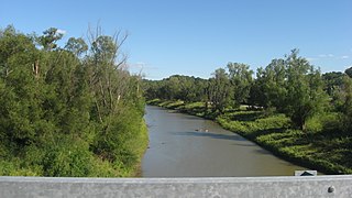
English: Looking eastward (downstream) along the old riverbed at the southern end of the causeway between Kaskaskia, Illinois and St. Mary, Missouri in the United States. Until a catastrophic shift in 1881, this small stream was the Mississippi River. |
||
| 日期 | 攝於2012年9月8日 | ||
| 來源 | 自己的作品 | ||
| 作者 | Nyttend | ||
| 授權許可 (重用此檔案) |
|
檔案歷史
點選日期/時間以檢視該時間的檔案版本。
| 日期/時間 | 縮圖 | 尺寸 | 用戶 | 備註 | |
|---|---|---|---|---|---|
| 目前 | 2012年9月24日 (一) 04:01 | | 2,816 × 1,584(1.87 MB) | Nyttend(對話 | 貢獻) | {{Location|37|52|48|N|89|56|53|W}} {{Information |Description={{en|Looking eastward (downstream) along the old riverbed at the southern end of the causeway between {{w|Kaskaskia, Illinois|Kaskaskia}}, {{w|Illinois}} and {{w|St. Mary, Missouri|St. Mary}... |
無法覆蓋此檔案。
檔案用途
下列頁面有用到此檔案:
全域檔案使用狀況
以下其他 wiki 使用了這個檔案:
- ar.wikipedia.org 的使用狀況
- azb.wikipedia.org 的使用狀況
- ca.wikipedia.org 的使用狀況
- ceb.wikipedia.org 的使用狀況
- ce.wikipedia.org 的使用狀況
- cy.wikipedia.org 的使用狀況
- en.wikipedia.org 的使用狀況
- es.wikipedia.org 的使用狀況
- eu.wikipedia.org 的使用狀況
- fa.wikipedia.org 的使用狀況
- ht.wikipedia.org 的使用狀況
- it.wikipedia.org 的使用狀況
- lld.wikipedia.org 的使用狀況
- pl.wikipedia.org 的使用狀況
- pt.wikipedia.org 的使用狀況
- sh.wikipedia.org 的使用狀況
- sr.wikipedia.org 的使用狀況
- sv.wikipedia.org 的使用狀況
- tt.wikipedia.org 的使用狀況
- uk.wikipedia.org 的使用狀況
- ur.wikipedia.org 的使用狀況
- uz.wikipedia.org 的使用狀況
- www.wikidata.org 的使用狀況
- zh-min-nan.wikipedia.org 的使用狀況
- zh.wikipedia.org 的使用狀況