File:Old Stone Inn.jpg
Zur Navigation springen
Zur Suche springen

Größe dieser Vorschau: 800 × 557 Pixel. Weitere Auflösungen: 320 × 223 Pixel | 640 × 445 Pixel | 1.024 × 713 Pixel | 1.280 × 891 Pixel | 2.560 × 1.782 Pixel | 4.654 × 3.239 Pixel.
Originaldatei (4.654 × 3.239 Pixel, Dateigröße: 2,04 MB, MIME-Typ: image/jpeg)
Bildtexte
Kurzbeschreibungen
Ergänze eine einzeilige Erklärung, was diese Datei darstellt.
|
Dieses Bild zeigt ein Objekt, das im National Register of Historic Places der Vereinigten Staaten verzeichnet ist. Die Referenznummer lautet 76000944. |
| Kameraposition | | Dieses und weitere Bilder auf OpenStreetMap |
|---|
| Beschreibung |
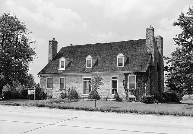
English: Front of the Old Stone Inn, located along U.S. Route 60 east of Simpsonville in Shelby County, Kentucky, United States. Built in 1816, it is listed on the National Register of Historic Places. |
|||||
| Datum | ||||||
| Quelle | Library of Congress, Prints and Photograph Division HABS: KY,106-SHELB.V,2-1 | |||||
| Urheber | Lester Jones | |||||
| Genehmigung (Weiternutzung dieser Datei) |
|


|
Dieses Bild ist unter der digitalen ID hhh.ky0112 in der Abteilung für Drucke und Fotografien der US-amerikanischen Library of Congress abrufbar.
Diese Markierung zeigt nicht den Urheberrechtsstatus des zugehörigen Werks an. Es ist in jedem Falle zusätzlich eine normale Lizenzvorlage erforderlich. Siehe Commons:Lizenzen für weitere Informationen.
|
Dateiversionen
Klicke auf einen Zeitpunkt, um diese Version zu laden.
| Version vom | Vorschaubild | Maße | Benutzer | Kommentar | |
|---|---|---|---|---|---|
| aktuell | 15:11, 20. Jan. 2010 | | 4.654 × 3.239 (2,04 MB) | Nyttend (Diskussion | Beiträge) | {{Location|38|13|21|N|85|20|52|W}} {{Information |Description={{en|Front of the {{w|Old Stone Inn}}, located along {{w|U.S. Route 68}} east of {{w|Simpsonville, Kentucky|Simpsonville}} in {{w|Shelby County, Kentucky|Shelby County}}, {{w|Kentucky}}, {{w|Un |
Du kannst diese Datei nicht überschreiben.
Dateiverwendung
Keine Seiten verwenden diese Datei.
Globale Dateiverwendung
Die nachfolgenden anderen Wikis verwenden diese Datei:
- Verwendung auf arz.wikipedia.org
- Verwendung auf ceb.wikipedia.org
- Verwendung auf de.wikipedia.org
- Verwendung auf en.wikipedia.org
- Verwendung auf ro.wikipedia.org
- Verwendung auf www.wikidata.org
Metadaten
Kategorien:
- Built in Kentucky in 1816
- Black and white photographs of buildings
- Black and white photographs of Kentucky
- Federal architecture in Kentucky
- Historic American Buildings Survey of Kentucky
- Hotels in Kentucky
- National Register of Historic Places in Shelby County, Kentucky
- Stone buildings in Shelby County, Kentucky
- U.S. Route 60 in Kentucky
- 1940 in Kentucky