File:Osmanli Ortadogu.jpg
跳转到导航
跳转到搜索

本预览的尺寸:786 × 600像素。 其他分辨率:315 × 240像素 | 629 × 480像素 | 1,006 × 768像素 | 1,280 × 977像素 | 2,560 × 1,954像素 | 7,374 × 5,629像素。
原始文件 (7,374 × 5,629像素,文件大小:9.42 MB,MIME类型:image/jpeg)
说明
说明
添加一行文字以描述该文件所表现的内容
摘要[编辑]
| 描述 |
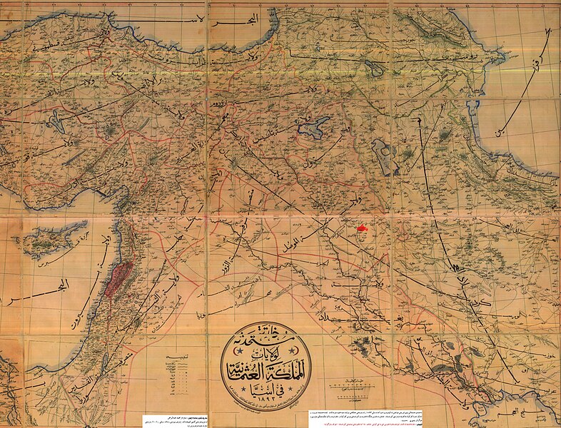
English: An Ottoman-era (1893) map of the Middle East, with the city of Kirkuk highlighted in the Mosul Vilayet
فارسی: بندانگشتی|نقشه منطقه کردستان مربوط به سال ۱۸۹۳ میلادی. که در آن زمان شامل ایالات غربی ایران به همراه ولایات موصل و دیاربکر و وان از امپراتوری عثمانی میشدهاست.
Türkçe: II. Abdülhamit döneminde basılmış Osmanlı Devleti'nin Ortadoğu'daki topraklarını gösteren harita (1893). haritanın tam ortasında کردستان (Kürdistan) kelimesi bulunmaktadır |
| 日期 | |
| 来源 | |
| 作者 | 未知 |
许可协议[编辑]
This work first published in the Ottoman Empire is now in the public domain because the Empire's copyright formalities were not met (copyright notice, registration, and deposit), or because the copyright term (30 years after the death of the author, sometimes less) expired before the Empire was dissolved (details).
|
.svg) |
原始上传日志[编辑]
原始描述頁面位於這裡。下列使用者名稱均來自ku.wikipedia。
- 2007-05-26 08:12 Erdal Ronahi 7374×5629× (9881565 bytes) {{Înformasyon |Şayes=Nexşeya Asyayê |Çavkanî=Arşîvên Osmanî, pukmedia.com |Nûser=Dewleta Osmanî |Dem=1893, di serdema xîlafeta siltan Ebdulhemîd de |Lîsens={{PD-old}} }}
文件历史
点击某个日期/时间查看对应时刻的文件。
| 日期/时间 | 缩略图 | 大小 | 用户 | 备注 | |
|---|---|---|---|---|---|
| 当前 | 2009年3月19日 (四) 01:07 | | 7,374 × 5,629(9.42 MB) | KureCewlik81(留言 | 贡献) | {{Information |Description=Anatolien zu Zeit des osmanischen Reiches 1893 |Source= |Date= |Author= |Permission= |other_versions= }} |
您不可以覆盖此文件。
文件用途
以下页面使用本文件:
- File:Osmanlimap1893.jpg(文件重定向)
全域文件用途
以下其他wiki使用此文件:
- ar.wikipedia.org上的用途
- arz.wikipedia.org上的用途
- azb.wikipedia.org上的用途
- az.wikipedia.org上的用途
- ckb.wikipedia.org上的用途
- de.wikipedia.org上的用途
- en.wikipedia.org上的用途
- fa.wikipedia.org上的用途
- ja.wikipedia.org上的用途
- ku.wikipedia.org上的用途
- mzn.wikipedia.org上的用途
- ru.wikipedia.org上的用途
- tr.wikipedia.org上的用途
- zh.wikipedia.org上的用途