File:Ottoman Empire Administrative Divisions.png
পরিভ্রমণে চলুন
অনুসন্ধানে চলুন
এই প্রাকদর্শনের আকার: ৫৫২ × ৬০০ পিক্সেল। অন্যান্য আকারসমূহ: ২২১ × ২৪০ পিক্সেল | ৪৪২ × ৪৮০ পিক্সেল | ৭০৭ × ৭৬৮ পিক্সেল | ৯৪৩ × ১,০২৪ পিক্সেল | ১,৮৮৫ × ২,০৪৮ পিক্সেল | ৪,৪৫৫ × ৪,৮৪০ পিক্সেল।
মূল ফাইল (৪,৪৫৫ × ৪,৮৪০ পিক্সেল, ফাইলের আকার: ২.১ মেগাবাইট, এমআইএমই ধরন: image/png)
ক্যাপশনসমূহ
ক্যাপশন
এই ফাইল কি প্রতিনিধিত্ব করছে তার এক লাইন ব্যাখ্যা যোগ করুন
সারাংশ[সম্পাদনা]
| বিবরণ |
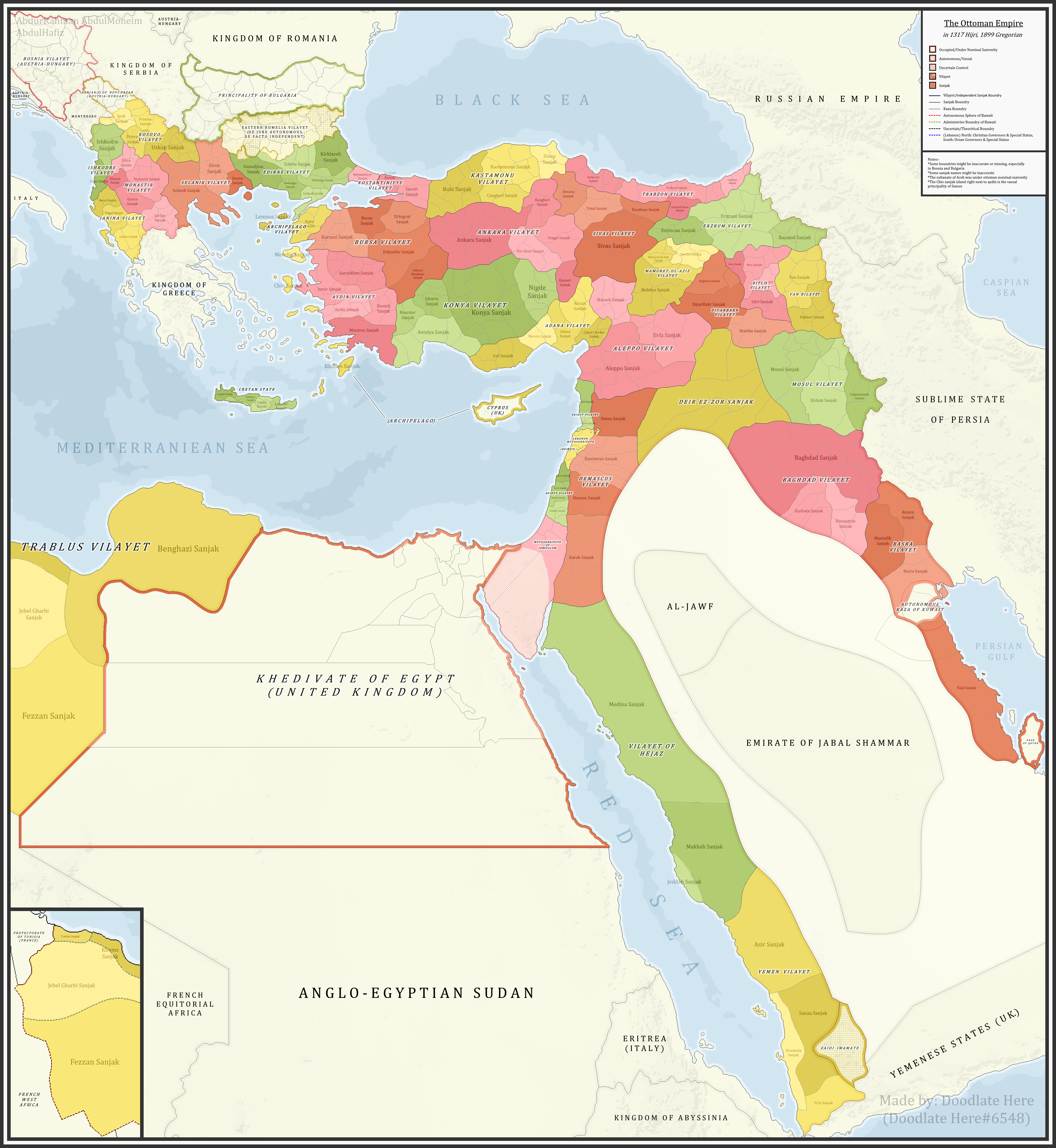
English: A detailed map showing the Ottoman Empire and its dependencies, including its administrative divisions, in 1899 CE (1317 Hijri). |
| তারিখ | |
| উৎস |
নিজের কাজ References:The sources that back up the maps are as follows: [1] Pavet de Courteille, Abel (1876). État présent de l'empire ottoman (in French). J. Dumaine. pp. 91–96. (for Yemen) [2] http://tarihvemedeniyet.org/2009/10/trablus-garb-vilayeti.html for Tripolitania [3] http://tarihvemedeniyet.org/2009/10/bosna-vilayeti.html for Bosnia [4] https://www.nsi.bg/nrnm/index.php?i=1&ezik=en for eastern Rumelia [5] http://hdl.loc.gov/loc.gmd/g7431f.ct002181 (Rest of Ottoman subdivisions, taken from the United States Library of Congress's Geography & Map Division, digital ID g7431f.ct002181) |
| লেখক | AbdurRahman AbdulMoneim |
লাইসেন্স প্রদান[সম্পাদনা]
আমি, এই কাজের স্বত্বাধিকারী, এতদ্দ্বারা আমি এই কাজকে নিম্ন বর্ণিত লাইসেন্সের আওতায় প্রকাশ করলাম:
এই ফাইলটি ক্রিয়েটিভ কমন্স অ্যাট্রিবিউশন-শেয়ার অ্যালাইক ৪.০ আন্তর্জাতিক লাইসেন্সের আওতায় লাইসেন্সকৃত।
- আপনি স্বাধীনভাবে:
- বণ্টন করতে পারেন – এ কাজটি অনুলিপি, বিতরণ এবং প্রেরণ করতে পারেন
- পুনঃমিশ্রণ করতে পারেন – কাজটি অভিযোজন করতে পারেন
- নিম্নের শর্তাবলীর ভিত্তিতে:
- স্বীকৃতিপ্রদান – আপনাকে অবশ্যই যথাযথ স্বীকৃতি প্রদান করতে হবে, লাইসেন্সের একটি লিঙ্ক সরবরাহ করতে হবে এবং কোনো পরিবর্তন হয়েছে কিনা তা নির্দেশ করতে হবে। আপনি যেকোনো যুক্তিসঙ্গত পদ্ধতিতে এটি করতে পারেন। কিন্তু এমন ভাবে নয়, যাতে প্রকাশ পায় যে লাইসেন্সধারী আপনাকে বা আপনার এই ব্যবহারের জন্য অনুমোদন দিয়েছে।
- একইভাবে বণ্টন – আপনি যদি কাজটি পুনঃমিশ্রণ, রুপান্তর, বা এর ওপর ভিত্তি করে নতুন সৃষ্টিকর্ম তৈরি করেন, তবে আপনাকে অবশ্যই আপনার অবদান একই লাইসেন্স বা একই রকমের লাইসেন্সের আওতায় বিতরণ করতে হবে।
| Annotations | This image is annotated: View the annotations at Commons |
ফাইলের ইতিহাস
যেকোনো তারিখ/সময়ে ক্লিক করে দেখুন ফাইলটি তখন কী অবস্থায় ছিল।
| তারিখ/সময় | সংক্ষেপচিত্র | মাত্রা | ব্যবহারকারী | মন্তব্য | |
|---|---|---|---|---|---|
| বর্তমান | ০৭:১৬, ১৬ নভেম্বর ২০২১ | | ৪,৪৫৫ × ৪,৮৪০ (২.১ মেগাবাইট) | BasilLeaf (আলোচনা | অবদান) | updates |
| ১৯:২২, ৫ মে ২০২১ |  | ৪,৪৫৫ × ৪,৮৪০ (২.১১ মেগাবাইট) | Super Dromaeosaurus (আলোচনা | অবদান) | Romanian Black Sea Snake Island, Romanian-Russian border at Dobruja-Bessarabia, removed lands in Banat that didn't belong to Romania then | |
| ১৮:১৭, ১৪ এপ্রিল ২০২১ |  | ৪,৪৫৫ × ৪,৮৪০ (২.০৩ মেগাবাইট) | محمد٢ (আলোচনা | অবদান) | Reverted to version as of 18:40, 19 January 2021 (UTC) | |
| ০২:০৫, ৮ ফেব্রুয়ারি ২০২১ |  | ৪,৪৫৫ × ৪,৮৪০ (২.১ মেগাবাইট) | BasilLeaf (আলোচনা | অবদান) | Minor name fixes. Iran's official English name was "Sublime State of Persia". "Arab Gulf" Doesn't exist. There's "Arabian Gulf", a name that only came to decently widespread usage from 1960s. Contemporary internationally accepted term is "Persian Gulf". | |
| ১৮:৪০, ১৯ জানুয়ারি ২০২১ |  | ৪,৪৫৫ × ৪,৮৪০ (২.০৩ মেগাবাইট) | Userd898 (আলোচনা | অবদান) | minor edit regarding the recoloring of a wrongly colored spot in haasa | |
| ১৮:০৫, ১৯ জানুয়ারি ২০২১ |  | ৪,৪৫৫ × ৪,৮৪০ (২.০৩ মেগাবাইট) | Userd898 (আলোচনা | অবদান) | fixed some mistakes in yemen and labeled qatar as occupied source: https://www.euratlas.net/history/hisatlas/arabia/1904__AR.html | |
| ১৮:৪৮, ১৪ জানুয়ারি ২০২১ |  | ৪,৪৫৫ × ৪,৮৪০ (২.১ মেগাবাইট) | BasilLeaf (আলোচনা | অবদান) | Minor name fixes. Iran's official English name was "Sublime State of Persia". "Arab Gulf" Doesn't exist. There's "Arabian Gulf", a name that only came to decently widespread usage in 1960s. | |
| ১৯:১৫, ২৭ ডিসেম্বর ২০২০ |  | ৪,৪৫৫ × ৪,৮৪০ (২.০৩ মেগাবাইট) | Userd898 (আলোচনা | অবদান) | Uploaded own work with UploadWizard |
আপনি এই ফাইলটি প্রতিস্থাপন করতে পারবেন না।
ফাইলের ব্যবহার
নিম্নলিখিত 4টি পাতা এই ফাইল ব্যবহার করে:
ফাইলের বৈশ্বিক ব্যবহার
নিচের অন্যান্য উইকিগুলো এই ফাইলটি ব্যবহার করে:
- bg.wikipedia.org-এ ব্যবহার
- bn.wikipedia.org-এ ব্যবহার
- ca.wikipedia.org-এ ব্যবহার
- ckb.wikipedia.org-এ ব্যবহার
- de.wikipedia.org-এ ব্যবহার
- el.wikipedia.org-এ ব্যবহার
- en.wikipedia.org-এ ব্যবহার
- Ottoman Empire
- Sanjak
- Administrative divisions of the Ottoman Empire
- Kosovo vilayet
- Baghdad vilayet
- Mosul vilayet
- Scutari vilayet
- Basra vilayet
- Ottoman Tripolitania
- Ottoman Syria
- Abdul Hamid II
- Ottoman Iraq
- Mount Lebanon Mutasarrifate
- Janina vilayet
- Beirut vilayet
- Syria vilayet
- Hejaz vilayet
- Talk:Greater Palestine
- User:Falcaorib
- es.wikipedia.org-এ ব্যবহার
- fa.wikipedia.org-এ ব্যবহার
- fi.wikipedia.org-এ ব্যবহার
- fr.wikipedia.org-এ ব্যবহার
- gl.wikipedia.org-এ ব্যবহার
- he.wikipedia.org-এ ব্যবহার
- it.wikipedia.org-এ ব্যবহার
এই ফাইলের অন্যান্য বৈশ্বিক ব্যবহার দেখুন।