File:Outcrop of Eppelsheim Fm PLoS ONE 7(5) e36817 fig 1.TIF
Aller à la navigation
Aller à la recherche

Taille de cet aperçu JPG pour ce fichier TIF : 800 × 427 pixels. Autres résolutions : 320 × 171 pixels | 640 × 341 pixels | 1 024 × 546 pixels | 1 811 × 966 pixels.
Fichier d’origine (1 811 × 966 pixels, taille du fichier : 225 kio, type MIME : image/tiff)
Légendes
Légendes
Ajoutez en une ligne la description de ce que représente ce fichier

|
Cette image (de type carte) devrait être recréée dans un format vectoriel, en tant que fichier SVG. Cela offrirait plusieurs avantages : voir Commons:Media for cleanup pour plus d'informations. Si une version SVG de cette image est déjà disponible, merci de bien vouloir l'envoyer. Après cela, remplacez ce modèle par {{vector version available|nouveau nom d'image.svg}}.
|
Description
[modifier]| Description |
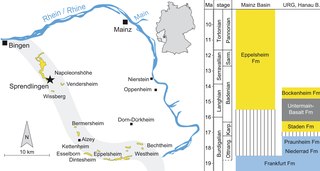
English: Original figure caption: Left: Geographic position of the Sprendlingen [vertebrate fossil] locality. Outcrops of the Eppelsheim Formation are displayed in yellow and the reconstructed course of the proto-Rhine is marked in grey (according to Franzen (2006)). Right: Lithostratigraphy of Mainz Basin, Upper Rhine Graben (URG) and Hanau Basin and their chronostratigraphic correlation (international and regional stages) according to Radtke & Kuemmerle (2004), Radtke & Martini (2008). Eppelsheim Formation is modified according [to] present results. Coloring represent carbonatic (blue) and siliciclastic (yellow) depositional systems. Abbreviations: Ottnan. = Ottnangian, Karp. = Karpatian, Sarm. = Sarmatian.
Deutsch: Original-Bildunterschrift (Übersetzung): Links: Geographische Lage der [Wirbeltierfossil-] Lokalität Sprendlingen. Ausbisse der Eppelsheim-Formation sind in gelb dargestellt, und der rekonstruierte Verlauf des Proto-Rheins ist grau markiert (nach Franzen (2006)). Rechts: Lithostratigraphie des Mainzer Beckens, des Oberrheingrabens (URG) und des Hanauer Beckens sowie Korrelation der Einheiten mit den chronostratigraphischen globalen und regionalen Stufen (nach Radtke & Kuemmerle (2004), Radtke & Martini (2008)). Die Reichweite der Eppelsheim-Formation ist nach den vorliegenden Ergebnissen verändert. Die Farben stehen für karbonatische (blau) und siliziklastische (gelb) Ablagerungssysteme. Abkürzungen: Ottnan. = Ottnangium, Karp. = Karpatium, Sarm. = Sarmatium. |
| Date | |
| Source | The Antiquity of the Rhine River: Stratigraphic Coverage of the Dinotheriensande (Eppelsheim Formation) of the Mainz Basin (Germany). PLoS ONE 7(5): e36817. doi:10.1371/journal.pone.0036817, fig 1 therein |
| Auteur | Madelaine Böhme, Manuela Aiglstorfer, Dieter Uhl, Ottmar Kullmer |
Conditions d’utilisation
[modifier]|
Ce fichier est disponible selon les termes de la licence Creative Commons Attribution 2.5 Générique.
|
Cette image a été publiée dans un journal de la Public Library of Science. Leur site web indique que le contenu de tous les journaux de la PLOS sont publiés sous licence Creative Commons Attribution 2.5.
À celui qui importe l'image : Vous devez indiquer un lien (URL) vers l’image ou l’article d’origine. |
Historique du fichier
Cliquer sur une date et heure pour voir le fichier tel qu'il était à ce moment-là.
| Date et heure | Vignette | Dimensions | Utilisateur | Commentaire | |
|---|---|---|---|---|---|
| actuel | 6 mai 2020 à 11:53 |  | 1 811 × 966 (225 kio) | Ras67 (d | contributions) | black frame removed, LZW compression optimized |
| 27 juillet 2016 à 02:47 |  | 1 815 × 970 (415 kio) | Gretarsson (d | contributions) | {{Information |Description ={{en|1=Original figure caption: ''Left: Geographic position of the Sprendlingen [vertebrate fossil] locality. Outcrops of the Eppelsheim Formation are displayed in yellow and the reconstructed course of the proto-Rhine is... |
Vous ne pouvez pas remplacer ce fichier.
Utilisations locales du fichier
La page suivante utilise ce fichier :
Utilisations du fichier sur d’autres wikis
Les autres wikis suivants utilisent ce fichier :
- Utilisation sur de.wikipedia.org
- Utilisation sur eo.wikipedia.org
- Utilisation sur fr.wikipedia.org
- Utilisation sur outreach.wikimedia.org