File:Outflow bndry.png
Ir a la navegación
Ir a la búsqueda

Tamaño de esta previsualización: 318 × 598 píxeles. Otras resoluciones: 127 × 240 píxeles | 255 × 480 píxeles | 408 × 768 píxeles | 1236 × 2325 píxeles.
Archivo original (1236 × 2325 píxeles; tamaño de archivo: 1,3 MB; tipo MIME: image/png)
Leyendas
Leyendas
Añade una explicación corta acerca de lo que representa este archivo
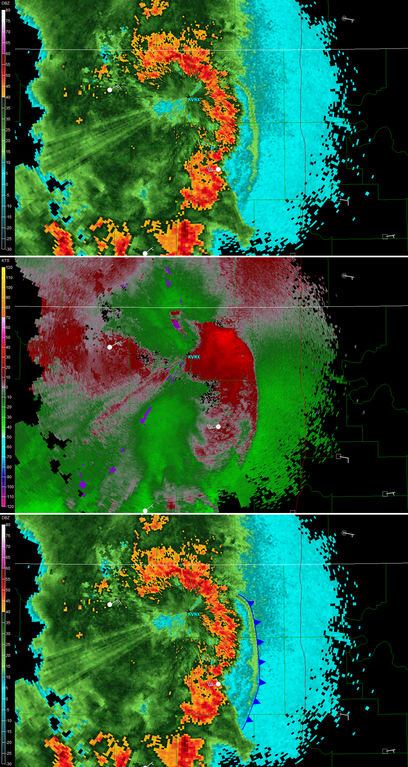
| Descripción | Coposite radar image of an outflow boundary coming from a Thumderstorm. Upper image shows strong reflectivities in the thunderstorms (Red) while a weaker line of echoes (Light green in the cyan area to the right) indicate the convection generated by the gust front. In the centre, the Doppler velocities relative the radar shows a zone of convergence (red away from radar and green towards it) on the outer edge of the weak line of echoes. At the bottom, the outflow boundary is indicated on the reflectivity image as a cold front line. |
| Fecha | (UTC) |
| Fuente | Created by Vaughan Weather using free NWS level 2 NEXRAD data |
| Autor | Theonlysilentbob |
| Otras versiones | en:Image:Outflow bndry.png |
Theonlysilentbob de la Wikipedia en inglés, titular de los derechos de autor de esta obra, la publica en los términos de la siguiente licencia:

|
Se autoriza la copia, distribución y modificación de este documento bajo los términos de la licencia de documentación libre GNU, versión 1.2 o cualquier otra que posteriormente publique la Fundación para el Software Libre; sin secciones invariables, textos de portada, ni textos de contraportada. Se incluye una copia de la dicha licencia en la sección titulada Licencia de Documentación Libre GNU. |
| Este archivo se encuentra bajo la licencia Creative Commons Genérica de Atribución/Compartir-Igual 3.0. | ||
| Atribución: Theonlysilentbob | ||
| ||
| Esta etiqueta de licencia fue agregada a este archivo como parte de la actualización de la licencia GFDL. |
Historial del archivo
Haz clic sobre una fecha y hora para ver el archivo tal como apareció en ese momento.
| Fecha y hora | Miniatura | Dimensiones | Usuario | Comentario | |
|---|---|---|---|---|---|
| actual | 00:45 18 oct 2007 | | 1236 × 2325 (1,3 MB) | Pierre cb (discusión | contribs.) | {{Information |Description=Coposite radar image of an outflow boundary coming from a Thumderstorm. Upper image shows strong reflectivities in the thunderstorms (Red) while a weaker line of echoes (Light green in the cyan area to the right) indicate the co |
No puedes sobrescribir este archivo.
Usos del archivo
La siguiente página usa este archivo:
Uso global del archivo
Las wikis siguientes utilizan este archivo:
- Uso en ca.wikipedia.org
- Uso en en.wikipedia.org
- Uso en es.wikipedia.org
- Uso en fr.wikipedia.org
- Uso en nn.wikipedia.org