File:Péninsule ibérique en 1037.png
Aller à la navigation
Aller à la recherche

Taille de cet aperçu : 800 × 600 pixels. Autres résolutions : 320 × 240 pixels | 640 × 480 pixels | 1 024 × 768 pixels | 1 280 × 960 pixels | 2 000 × 1 500 pixels.
Fichier d’origine (2 000 × 1 500 pixels, taille du fichier : 1 014 kio, type MIME : image/png)
Légendes
Légendes
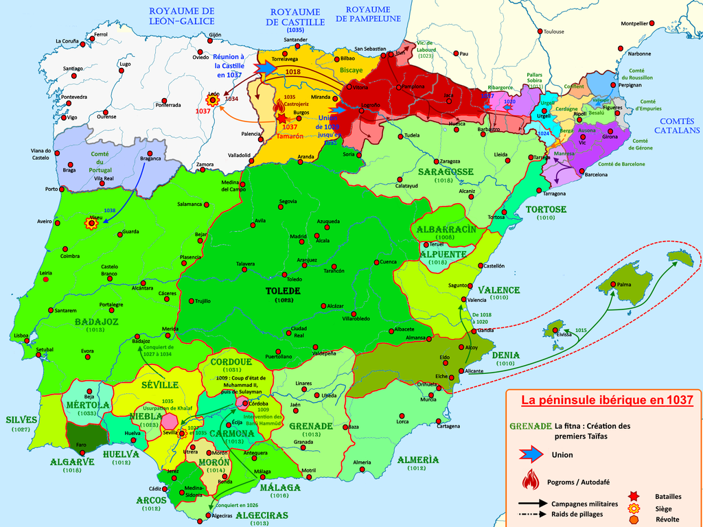
Carte de la péninsule ibérique de 1002 à 1037
Description[modifier]
| Description |
Français : Carte de la péninsule ibérique de 1002 à 1037 illustrant les principaux évènements |
| Date | |
| Source | Travail personnel |
| Auteur | Elryck |
Conditions d’utilisation[modifier]
Moi, en tant que détenteur des droits d’auteur sur cette œuvre, je la publie sous la licence suivante :
Ce fichier est sous la licence Creative Commons Attribution – Partage dans les Mêmes Conditions 4.0 International.
- Vous êtes libre :
- de partager – de copier, distribuer et transmettre cette œuvre
- d’adapter – de modifier cette œuvre
- Sous les conditions suivantes :
- paternité – Vous devez donner les informations appropriées concernant l'auteur, fournir un lien vers la licence et indiquer si des modifications ont été faites. Vous pouvez faire cela par tout moyen raisonnable, mais en aucune façon suggérant que l’auteur vous soutient ou approuve l’utilisation que vous en faites.
- partage à l’identique – Si vous modifiez, transformez, ou vous basez sur cette œuvre, vous devez distribuer votre contribution sous la même licence ou une licence compatible avec celle de l’original.
Historique du fichier
Cliquer sur une date et heure pour voir le fichier tel qu'il était à ce moment-là.
| Date et heure | Vignette | Dimensions | Utilisateur | Commentaire | |
|---|---|---|---|---|---|
| actuel | 27 août 2020 à 15:14 | | 2 000 × 1 500 (1 014 kio) | Elryck (d | contributions) | Ajout des progroms |
| 17 août 2020 à 19:19 |  | 2 000 × 1 500 (1 001 kio) | Elryck (d | contributions) | Nomenclatures | |
| 13 août 2020 à 12:57 |  | 2 000 × 1 500 (1 023 kio) | Elryck (d | contributions) | Correction de la légende corrompue lors d'une sauvegarde | |
| 13 août 2020 à 11:57 |  | 2 000 × 1 500 (1,01 Mio) | Elryck (d | contributions) | Version 1.0 | |
| 12 août 2020 à 06:29 |  | 2 000 × 1 500 (1 018 kio) | Elryck (d | contributions) | Uploaded own work with UploadWizard |
Vous ne pouvez pas remplacer ce fichier.
Utilisations locales du fichier
Les 2 pages suivantes utilisent ce fichier :
Utilisations du fichier sur d’autres wikis
Les autres wikis suivants utilisent ce fichier :
- Utilisation sur an.wikipedia.org
- Utilisation sur ca.wikipedia.org
- Utilisation sur fr.wikipedia.org
- Ferdinand Ier (roi de León)
- Califat de Cordoue
- Première période de taïfas
- Omeyyades de Cordoue
- Royaume de Navarre
- Royaume de León
- Bermude III
- García II de Castille
- Alphonse V (roi de León)
- Comtés catalans
- Histoire d'al-Andalus
- Sanche III (roi de Pampelune)
- Taïfa de Badajoz
- Taïfa de Séville
- Comté de Portugal
- Taïfa de Murcie
- Hammudites
- Reconquista
- Guerre civile en al-Andalus
- Al-Andalus
- Raymond Borrell de Barcelone
- Bérenger-Raimond Ier de Barcelone
- Royaume de Pampelune
- Taïfa
- Taïfa de Grenade
- Histoire de l'Aragon
- Comté de Castille
- Taïfa de Mértola
- Taïfa de Tolède
- Taïfa de Carmona
- Taïfa d'Almeria
- Taïfa de Cordoue
- Taïfa d'Arcos de la Frontera
- Taïfa de Niebla
- Campagne des Zirides en Ibérie
- Utilisateur:WRYSM/Brouillon2
- Utilisation sur it.wikipedia.org
Métadonnées
Catégories :
- French-language maps showing history of Europe
- Maps of the history of the Iberian Peninsula
- Maps of 11th-century Iberian Peninsula
- Reconquista maps of the Iberian Peninsula
- Iberian kingdoms
- Maps of Medieval Iberia
- Maps of Al-Andalus
- Maps of the Kingdom of León
- Maps of the history of Portugal
- Maps of Aragon
- Maps of the County of Barcelona
- Maps of Catalan counties
- Maps of the taifa kingdoms
- Territorial evolution of Spain
- Spain in the 1030s
- Maps of the County of Castile
- Portugal in the 11th century