File:Péninsule ibérique en 1224.png
Aller à la navigation
Aller à la recherche

Taille de cet aperçu : 800 × 600 pixels. Autres résolutions : 320 × 240 pixels | 640 × 480 pixels | 1 024 × 768 pixels | 1 280 × 960 pixels | 2 000 × 1 500 pixels.
Fichier d’origine (2 000 × 1 500 pixels, taille du fichier : 935 kio, type MIME : image/png)
Légendes
Légendes
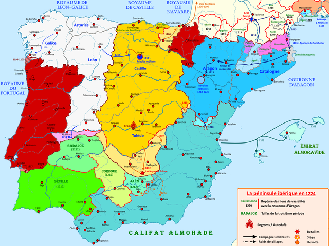
Carte de la péninsule ibérique en 1224
Description
[modifier]
| Description |
Français : Carte de la péninsule ibérique en 1224 illustrant les principaux évènements de l'époque |
| Date | |
| Source | Travail personnel |
| Auteur | Elryck |
Conditions d’utilisation
[modifier]
Moi, en tant que détenteur des droits d’auteur sur cette œuvre, je la publie sous la licence suivante :
Ce fichier est sous la licence Creative Commons Attribution – Partage dans les Mêmes Conditions 4.0 International.
- Vous êtes libre :
- de partager – de copier, distribuer et transmettre cette œuvre
- d’adapter – de modifier cette œuvre
- Sous les conditions suivantes :
- paternité – Vous devez donner les informations appropriées concernant l'auteur, fournir un lien vers la licence et indiquer si des modifications ont été faites. Vous pouvez faire cela par tout moyen raisonnable, mais en aucune façon suggérant que l’auteur vous soutient ou approuve l’utilisation que vous en faites.
- partage à l’identique – Si vous modifiez, transformez, ou vous basez sur cette œuvre, vous devez distribuer votre contribution sous la même licence ou une licence compatible avec celle de l’original.
Historique du fichier
Cliquer sur une date et heure pour voir le fichier tel qu'il était à ce moment-là.
| Date et heure | Vignette | Dimensions | Utilisateur | Commentaire | |
|---|---|---|---|---|---|
| actuel | 27 août 2020 à 15:15 | | 2 000 × 1 500 (935 kio) | Elryck (d | contributions) | Ajout des pogroms |
| 19 août 2020 à 07:44 |  | 2 000 × 1 500 (924 kio) | Elryck (d | contributions) | Correction de la couleur d'empuries | |
| 18 août 2020 à 13:05 |  | 2 000 × 1 500 (925 kio) | Elryck (d | contributions) | Uploaded own work with UploadWizard |
Vous ne pouvez pas remplacer ce fichier.
Utilisations locales du fichier
Les 2 pages suivantes utilisent ce fichier :
Utilisations du fichier sur d’autres wikis
Les autres wikis suivants utilisent ce fichier :
- Utilisation sur an.wikipedia.org
- Utilisation sur en.wikipedia.org
- Utilisation sur es.wikipedia.org
- Utilisation sur fr.wikipedia.org
- Alphonse VIII
- Almohades
- Couronne d'Aragon
- Jacques Ier (roi d'Aragon)
- Ferdinand III (roi de Castille)
- Alphonse IX
- Pierre II (roi d'Aragon)
- Sanche Ier (roi de Portugal)
- Alphonse II (roi de Portugal)
- Histoire du Portugal
- Royaume de Castille
- Royaume de Navarre
- Henri Ier (roi de Castille)
- Royaume de León
- Histoire d'al-Andalus
- Taïfa de Séville
- Sanche VII
- Reconquista
- Troisième période de taïfas
- Histoire de l'Aragon
- Taïfa de Cordoue
- Utilisateur:Mathious Ier/Histoire du Portugal (Brouillon)
- Utilisation sur it.wikipedia.org
Métadonnées
Catégories :
- French-language maps showing history of Europe
- Maps of 13th-century Iberian Peninsula
- Reconquista maps of the Iberian Peninsula
- Iberian kingdoms
- Maps of Al-Andalus
- Maps of the Kingdom of León
- Maps of the taifa kingdoms
- Maps of the Almohad Caliphate
- Territorial evolution of Spain
- Maps of the Crown of Aragon
- Maps of the Kingdom of Castile