File:PIA00327 crop 2x.png

原始文件 (1,200 × 1,200像素,文件大小:1.48 MB,MIME类型:image/png)
说明
说明
摘要
[编辑]| 描述 |
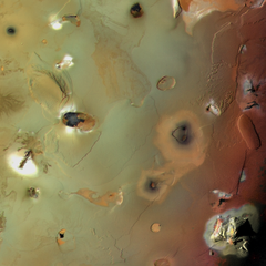
English: This is an edited version of NASA's image PIA00328, obtained by cropping, doubling the linear pixel density, and sharpening. The view shows two of Io's ten highest peaks, in the Euboea Montes, just below upper left, and Haemus Montes, at lower right (see Io Mountain Database). North is towards the left.
Many of the features in this image are annotated in Wikimedia Commons. NASA's description of the uncropped image is as follows (the description has been edited to reflect a 90-degree counterclockwise rotation present in the original but performed after the description was written): Io's volcanic plains are shown in this Voyager 1 image. Also visible are numerous volcanic calderas and two large mountains (Euboea Montes, just left of center, and Haemus Montes, at lower right). The plains include some distinct lava flows, such as those of Lerna Regio (upper right), and low mesas, such as Nemeas Planum (right center) and Dodona Planum (just below center). This scene is about 1,050 mi (1,700 km) from top to bottom.. The composition of Io's volcanic plains and lava flows has not been determined, but they could consist dominantly of sulfur or of silicates (such as basalt) coated with sulfurous condensates. The apparent erosion of the edges of some mesas suggests that they are composed of something volatile, possibly including a component of SO2 ice, which is observed spectroscopically to be widespread on Io. The high topographic relief in some areas, particularly of the montes, suggests that those areas are made primarily of silicate rock, which is much stronger than sulfur or SO2. The bright aureoles around several features probably consist of freshly deposited SO2 frost that was vented from cracks and volcanic conduits. |
| 日期 | |
| 来源 | http://www.ciclops.org/view.php?id=3571 |
| 作者 | NASA / Jet Propulsion Laboratory / USGS |
| 其他版本 |
|


许可协议
[编辑]
| 本文件完全由NASA创作,在美国属于公有领域。根据NASA的版权方针,NASA的材料除非另有声明否则不受版权保护。(参见Template:PD-USGov/zh、NASA版权方针页面或JPL图片使用方针。) | ||
 |
警告:
|
| 註解 | 該圖片含有註解:在維基媒體共享資源上查看註解 |
文件历史
点击某个日期/时间查看对应时刻的文件。
| 日期/时间 | 缩略图 | 大小 | 用户 | 备注 | |
|---|---|---|---|---|---|
| 当前 | 2012年7月2日 (一) 06:07 | | 1,200 × 1,200(1.48 MB) | WolfmanSF(留言 | 贡献) |
您不可以覆盖此文件。
文件用途
以下4个页面使用本文件:
全域文件用途
以下其他wiki使用此文件:
- ar.wikipedia.org上的用途
- en.wikipedia.org上的用途
- es.wikipedia.org上的用途
- fr.wikipedia.org上的用途
- it.wikipedia.org上的用途
- ja.wikipedia.org上的用途
- mk.wikipedia.org上的用途
- th.wikipedia.org上的用途
- tr.wikipedia.org上的用途
- zh.wikipedia.org上的用途