File:PIA01153.jpg
跳至導覽
跳至搜尋
預覽大小:798 × 133 像素。 其他解析度:320 × 53 像素 | 640 × 107 像素 | 4,201 × 701 像素。
原始檔案 (4,201 × 701 像素,檔案大小:817 KB,MIME 類型:image/jpeg)
說明
說明
添加單行說明來描述出檔案所代表的內容
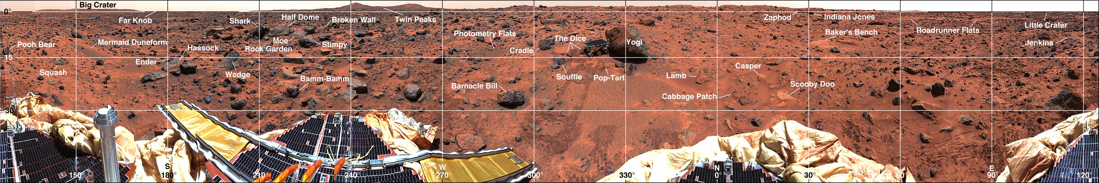
| 描述 | Mars-local-level (LL frame) coordinate map of rocks counted at the Mars Pathfinder landing site. Positions, apparent diameters (D), and heights (H) were measured to the nearest centimeter in the Mars map virtual reality environment constructed from the "Monster Pan" |
| 來源 | https://photojournal.jpl.nasa.gov/catalog/PIA01153 |
| 作者 | NASA |
| 授權許可 (重用此檔案) |
Original work of NASA - public domain |
| 其他版本 | http://photojournal.jpl.nasa.gov/catalog/PIA01153 |
| 本作品由NASA創作,屬於公有領域。根據NASA的版權政策:“NASA的創作除非另有聲明否則不受版權保護。”(參見:Template:PD-USGov/zh,NASA版權政策或JPL圖像使用政策) | ||
 |
警告:
|
檔案歷史
點選日期/時間以檢視該時間的檔案版本。
| 日期/時間 | 縮圖 | 尺寸 | 用戶 | 備註 | |
|---|---|---|---|---|---|
| 目前 | 2007年5月27日 (日) 18:33 | 4,201 × 701(817 KB) | Clh288~commonswiki(對話 | 貢獻) | {{Information |Description= Mars-local-level (LL frame) coordinate map of rocks counted at the Mars Pathfinder landing site. Positions, apparent diameters (D), and heights (H) were measured to the nearest centimeter in the Mars map virtual reality envi |
無法覆蓋此檔案。
檔案用途
下列頁面有用到此檔案:
全域檔案使用狀況
以下其他 wiki 使用了這個檔案:
- be.wikipedia.org 的使用狀況
- bg.wikipedia.org 的使用狀況
- en.wikipedia.org 的使用狀況
- ru.wikipedia.org 的使用狀況
- uk.wikipedia.org 的使用狀況
- zh.wikipedia.org 的使用狀況