File:PIA17655 crop Titan north polar seas and lakes.jpg

原始檔案 (3,000 × 3,000 像素,檔案大小:7.41 MB,MIME 類型:image/jpeg)
說明
說明
摘要
[編輯]
| 描述 |
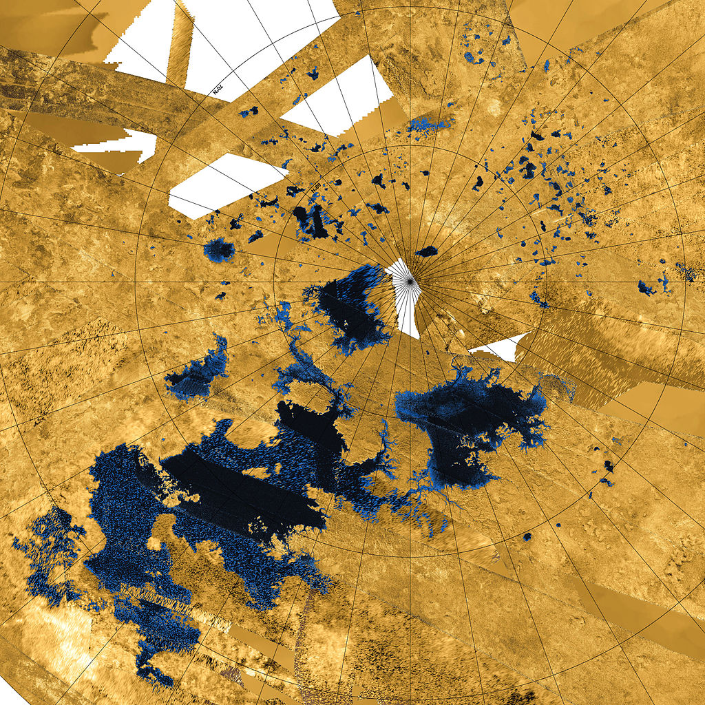
English: This colorized mosaic from NASA's Cassini mission shows the most complete view yet of Titan's northern land of lakes and seas. Saturn's moon Titan is the only world in our solar system other than Earth that has stable liquid on its surface. The liquid in Titan's lakes and seas is mostly methane and ethane.
The data were obtained by Cassini's radar instrument from 2004 to 2013. In this projection, the north pole is at the center. The view extends down to 50 degrees north latitude. In this color scheme, liquids appear blue and black depending on the way the radar bounced off the surface. Land areas appear yellow to white. A haze was added to simulate the Titan atmosphere. Kraken Mare, Titan's largest sea, is the body in black and blue that sprawls from just below and to the right of the north pole down to the bottom right. Ligeia Mare, Titan's second largest sea, is a nearly heart-shaped body to the left and above the north pole. Punga Mare is just below the north pole. The area above and to the left of the north pole is dotted with smaller lakes. Lakes in this area are about 30 miles (50 kilometers) across or less. Most of the bodies of liquid on Titan occur in the northern hemisphere. In fact nearly all the lakes and seas on Titan fall into a box covering about 600 by 1,100 miles (900 by 1,800 kilometers). Only 3 percent of the liquid at Titan falls outside of this area. Scientists are trying to identify the geologic processes that are creating large depressions capable of holding major seas in this limited area. A prime suspect is regional extension of the crust, which on Earth leads to the formation of faults creating alternating basins and roughly parallel mountain ranges. This process has shaped the Basin and Range province of the western United States, and during the period of cooler climate 13,000 years ago much of the present state of Nevada was flooded with Lake Lahontan, which (though smaller) bears a strong resemblance to the region of closely packed seas on Titan. A related flyover can be seen at PIA17656. The Cassini-Huygens mission is a cooperative project of NASA, the European Space Agency and the Italian Space Agency. NASA's Jet Propulsion Laboratory, a division of the California Institute of Technology in Pasadena, manages the mission for NASA's Science Mission Directorate, Washington, DC. The Cassini orbiter was designed, developed and assembled at JPL. The radar instrument was built by JPL and the Italian Space Agency, working with team members from the United States and several European countries. For more information about the Cassini-Huygens mission visit http://saturn.jpl.nasa.gov and http://www.nasa.gov/cassini. The original NASA image has been modified by rotating 90 deg. clockwise and cropping. Some of the features in this image have been annotated in Wikimedia Commons. |
| 日期 | |
| 來源 | http://photojournal.jpl.nasa.gov/catalog/PIA17655 |
| 作者 | NASA / JPL-Caltech / Agenzia Spaziale Italiana / USGS |
| 其他版本 |
Titan's North.jpg - Lower resolution, uncropped version (2860 × 2740 pixels, 6.07 MB) |
授權條款
[編輯]
| 本作品由NASA創作,屬於公有領域。根據NASA的版權政策:“NASA的創作除非另有聲明否則不受版權保護。”(參見:Template:PD-USGov/zh,NASA版權政策或JPL圖像使用政策) | ||
 |
警告:
|
| 註解 | 該圖片含有註解:在維基媒體共享資源上查看註解 |
檔案歷史
點選日期/時間以檢視該時間的檔案版本。
| 日期/時間 | 縮圖 | 尺寸 | 使用者 | 備註 | |
|---|---|---|---|---|---|
| 目前 | 2014年2月8日 (六) 07:21 | | 3,000 × 3,000(7.41 MB) | WolfmanSF(留言 | 貢獻) | Higher resolution version |
| 2013年12月13日 (五) 06:24 |  | 1,700 × 1,700(3.68 MB) | WolfmanSF(留言 | 貢獻) | User created page with UploadWizard |
無法覆蓋此檔案。
檔案用途
全域檔案使用狀況
以下其他 wiki 使用了這個檔案:
- an.wikipedia.org 的使用狀況
- ar.wikipedia.org 的使用狀況
- co.wikipedia.org 的使用狀況
- de.wikipedia.org 的使用狀況
- en.wikipedia.org 的使用狀況
- es.wikipedia.org 的使用狀況
- fr.wikibooks.org 的使用狀況
- hr.wikipedia.org 的使用狀況
- kw.wikipedia.org 的使用狀況
- lb.wikipedia.org 的使用狀況
- nn.wikipedia.org 的使用狀況
- pl.wikipedia.org 的使用狀況
- ru.wikipedia.org 的使用狀況
- uk.wikipedia.org 的使用狀況
- war.wikipedia.org 的使用狀況
- zh.wikipedia.org 的使用狀況