File:PIA17942-MarsOpportunityRover-PinnacleIslandRockMysterySolved-20140204.jpg

原始檔案 (1,020 × 1,020 像素,檔案大小:218 KB,MIME 類型:image/jpeg)
說明
說明
摘要
[編輯]
| 描述 |
English: Where Martian 'Jelly Doughnut' Rock Came From
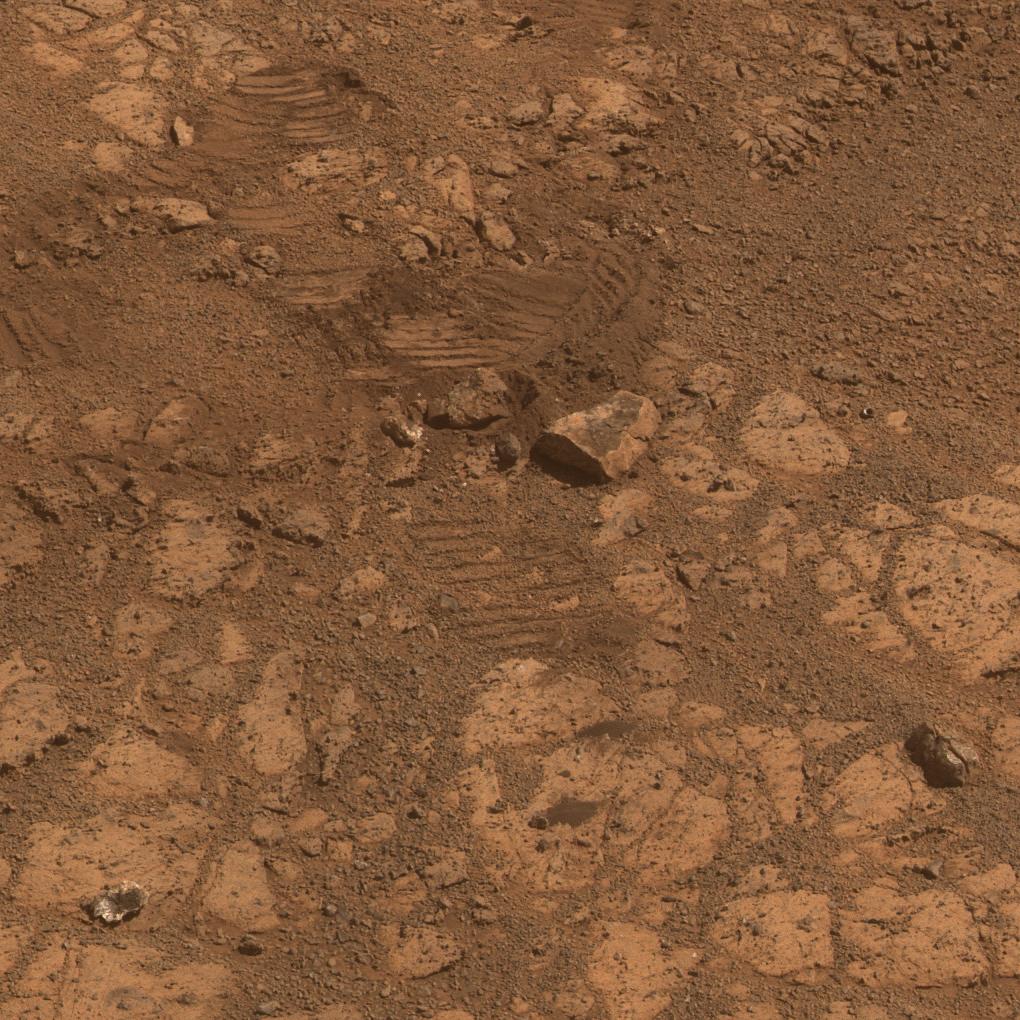
http://www.jpl.nasa.gov/spaceimages/details.php?id=PIA17942 http://www.jpl.nasa.gov/news/news.php?release=2014-051&1 http://www.nasa.gov/press/2014/february/mars-rover-heads-uphill-after-solving-doughnut-riddle This image from the panoramic camera (Pancam) on NASA's Mars Exploration Rover Opportunity shows the location of a rock called "Pinnacle Island" had been before it appeared in front of the rover in early January 2014. This image was taken during the 3,567th Martian day, or sol, of Opportunity's work on Mars (Feb. 4, 2014). Pinnacle Island, (see arrow in Figure 3 in the lower left corner of the scene), has a dark-red center and white rim, an appearance that has been likened to a jelly doughnut. It showed up in front of Opportunity in an image taken on Sol 3540 (Jan. 8, 2014) at a location where the rock had been absent in an image taken four sols earlier. Researchers used the microscopic imager and alpha particle X-ray spectrometer on Opportunity's robotic arm to examine Pinnacle Island for several days in January. In this February image, a rock that has been dubbed "Stuart Island," with similar dark-red center and white edge, is visible just left the scene (see arrow in Figure 3 at near center). Its location is uphill from Pinnacle Island. The rover's own solar panels blocked a view of it while the robotic-arm instruments were studying Pinnacle Island. The wheel track beside Stuart Island helps tell the story: Opportunity drove over a rock and broke it open. One of the pieces, Pinnacle Island, was knocked downhill. For scale, Pinnacle Island is about 3 feet (1 meter) from Stuart Island. The view merges exposures taken through three of the Pancam's color filters and is presented in approximate true color. A version in false color, to emphasize subtle color differences among Martian surface materials, is available as Figure 1. A stereo version, Figure2, appears three dimensional when viewed through red-blue glasses with the red lens on the left. JPL manages the Mars Exploration Rover Project for NASA's Science Mission Directorate in Washington. For more information about Spirit and Opportunity, visit http://www.nasa.gov/rovers. |
| 日期 | |
| 來源 | http://photojournal.jpl.nasa.gov/jpeg/PIA17942.jpg |
| 作者 | NASA/JPL-Caltech/Cornell Univ./Arizona State Univ. |
授權條款
[編輯]
| 本作品由NASA創作,屬於公有領域。根據NASA的版權政策:“NASA的創作除非另有聲明否則不受版權保護。”(參見:Template:PD-USGov/zh,NASA版權政策或JPL圖像使用政策) | ||
 |
警告:
|
檔案歷史
點選日期/時間以檢視該時間的檔案版本。
| 日期/時間 | 縮圖 | 尺寸 | 用戶 | 備註 | |
|---|---|---|---|---|---|
| 目前 | 2014年2月15日 (六) 06:31 | | 1,020 × 1,020(218 KB) | Drbogdan(對話 | 貢獻) | User created page with UploadWizard |
無法覆蓋此檔案。
檔案用途
全域檔案使用狀況
以下其他 wiki 使用了這個檔案:
- en.wikipedia.org 的使用狀況
- zh.wikipedia.org 的使用狀況