File:PIA18474-MarsCuriosityRover-GaleCrater-TopographicMap-PahrumpHills-20140911.jpg

原始文件 (3,300 × 2,550像素,文件大小:2.11 MB,MIME类型:image/jpeg)
说明
说明
摘要
[编辑]
| 描述 |
English: 09.11.2014
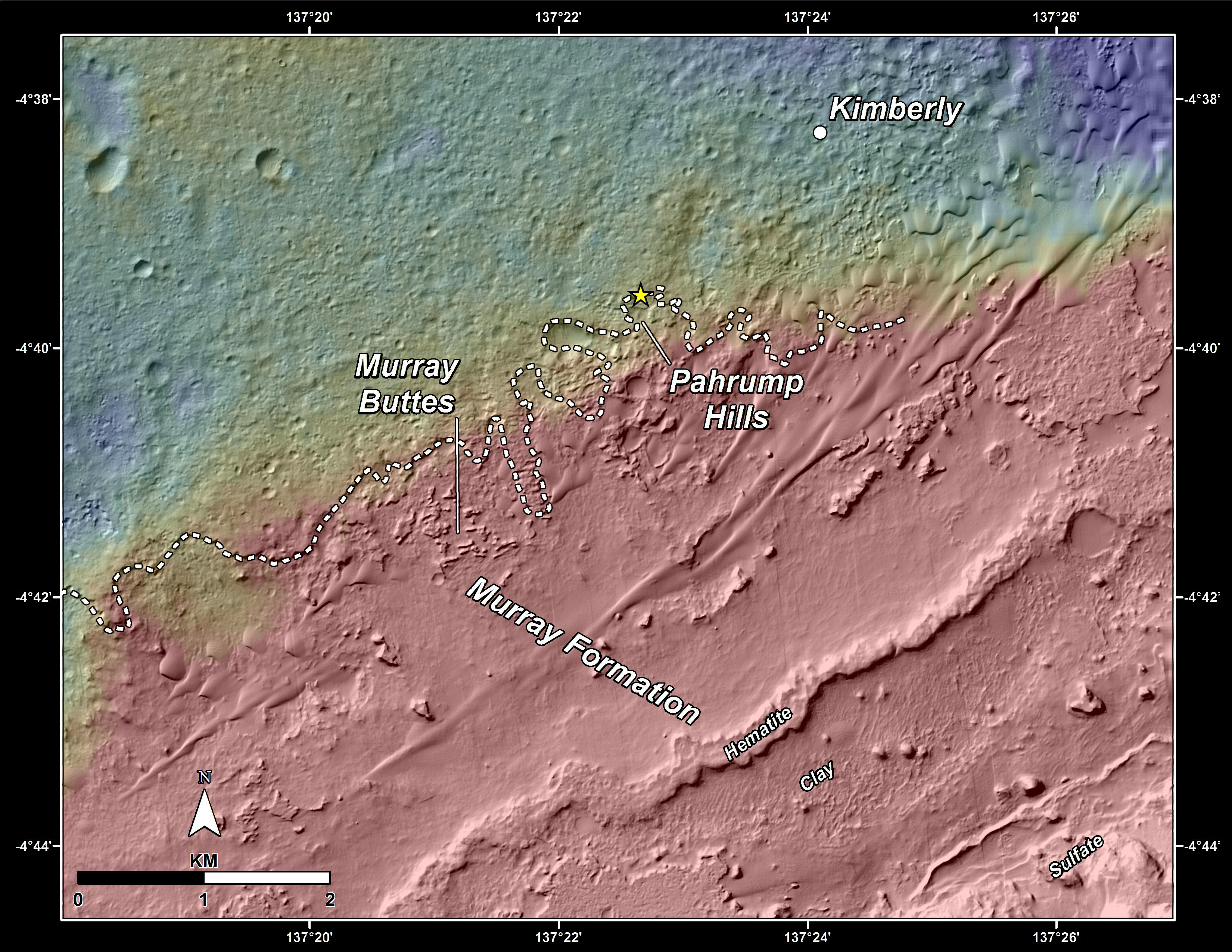
Slopes of Mount Sharp http://mars.jpl.nasa.gov/msl/multimedia/images/?ImageID=6573 This topography map shows a portion of the Gale Crater region on Mars, where NASA's Mars Curiosity rover landed on August 6, 2012. The rover (marked with a star) is currently headed toward "Pahrump Hills," which make up part of the "Murray Formation" of layered rocks. The white dashed line represents the contact point between rocks of Gale Crater's plains (Aeolis Palus) -- which Curiosity has investigated since landing -- and those at the base of Mt. Sharp (Aeolis Mons). By comparing the two images it can be seen that a small topographic scarp defines the contact region. In addition, the rocks of Aeolis Palus are heavily cratered whereas those of Mount Sharp have fewer craters. The maps are made using data from NASA's Mars Reconnaissance Orbiter's High Resolution Imaging Science Experiment, or HiRISE. NASA's Jet Propulsion Laboratory, a division of the California Institute of Technology, Pasadena, manages the Mars Science Laboratory Project for NASA's Science Mission Directorate, Washington. JPL designed and built the project's Curiosity rover. HiRISE is one of six instruments on the Mars Reconnaissance Orbiter. The University of Arizona, Tucson, operates HiRISE, which was built by Ball Aerospace & Technologies Corp., Boulder, Colorado. JPL manages the Mars Reconnaissance Orbiter Project for NASA's Science Mission Directorate, Washington. More information about Curiosity is online at http://www.nasa.gov/msl and http://mars.jpl.nasa.gov/msl/. |
| 日期 | |
| 来源 | http://mars.jpl.nasa.gov/msl/images/NASA-MSL-Curiosity-Rover-Gale-Crater-Topographic-Map-Pahrump-Hills-pia18474-full.jpg |
| 作者 | NASA/JPL-Caltech/Univ. of Arizona |
许可协议
[编辑]
| 本文件完全由NASA创作,在美国属于公有领域。根据NASA的版权方针,NASA的材料除非另有声明否则不受版权保护。(参见Template:PD-USGov/zh、NASA版权方针页面或JPL图片使用方针。) | ||
 |
警告:
|
文件历史
点击某个日期/时间查看对应时刻的文件。
| 日期/时间 | 缩略图 | 大小 | 用户 | 备注 | |
|---|---|---|---|---|---|
| 当前 | 2014年9月19日 (五) 15:18 | | 3,300 × 2,550(2.11 MB) | Drbogdan(留言 | 贡献) | User created page with UploadWizard |
您不可以覆盖此文件。
文件用途
没有页面使用本文件。
全域文件用途
以下其他wiki使用此文件:
- en.wikipedia.org上的用途
- tr.wikipedia.org上的用途
- uk.wikipedia.org上的用途
- zh.wikipedia.org上的用途