File:PIA19080-MarsRoverCuriosity-AncientGaleLake-Simulated-20141208.jpg

原始文件 (2,560 × 1,600像素,文件大小:1.05 MB,MIME类型:image/jpeg)
说明
说明
摘要[编辑]
| 描述 |
English: December 8, 2014
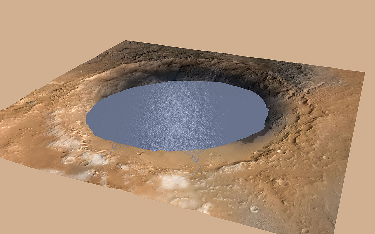
Simulated View of Gale Crater Lake on Mars http://mars.jpl.nasa.gov/msl/multimedia/images/?ImageID=6875 This simulation depicts a lake partially filling Mars' Gale Crater, receiving runoff from snow melting on the crater's rim. Evidence that NASA's Curiosity rover has found of ancient streams, deltas and lakes suggests the crater held a lake such as this more than three billion years ago. This illustration depicts a lake of water partially filling Mars' Gale Crater, receiving runoff from snow melting on the crater's northern rim. Evidence of ancient streams, deltas and lakes that NASA's Curiosity Mars rover mission has found in the patterns of sedimentary deposits in Gale Crater suggests the crater held a lake such as this more than three billion years ago, filling and drying in multiple cycles over tens of millions of years. Gale Crater is 96 miles (154 kilometers) in diameter. This view is looking toward the southeast. The land surface in this illustration is the area's modern shape. Three billion years ago, the rim would have been higher and less eroded. A large layered mountain, Mount Sharp, now stands in the middle of Gale Crater. Accumulation of sediments in lakes, deltas, streams and wind-blown deposits is proposed to have formed the layers making up the lower portion of the mountain. When the crater first held a lake, it might have had central peak, much smaller than Mount Sharp, formed as a rebound from the impact that excavated the crater. Such a peak might have appeared as an island in the lake. This illustration incorporates portions of a simulated oblique view of Gale Crater (http://photojournal.jpl.nasa.gov/catalog/PIA15292) based on elevation data from the High Resolution Stereo Camera on the European Space Agency's Mars Express orbiter, image data from the Context Camera on NASA's Mars Reconnaissance Orbiter, and color information from Viking Orbiter imagery. The appearance of snow is added as part of the simulation of conditions from billions of years ago. The lake is depicted filling the crater approximately to the elevation where Curiosity found lakebed sediments in the "Pahrump Hills" outcrop at the base of Mount Sharp. For more information about the Mars Science Laboratory mission and the mission's Curiosity rover, visit http://www.nasa.gov/msl and http://mars.nasa.gov/msl/. |
| 日期 | |
| 来源 | http://mars.jpl.nasa.gov/msl/images/mars-rover-curiosity-Meyer-Vasavada-Gale-Lake-pia19080-full.jpg |
| 作者 | NASA/JPL-Caltech/ESA/DLR/FU Berlin/MSSS |
许可协议[编辑]
| 本文件完全由NASA创作,在美国属于公有领域。根据NASA的版权方针,NASA的材料除非另有声明否则不受版权保护。(参见Template:PD-USGov/zh、NASA版权方针页面或JPL图片使用方针。) | ||
 |
警告:
|
文件历史
点击某个日期/时间查看对应时刻的文件。
| 日期/时间 | 缩略图 | 大小 | 用户 | 备注 | |
|---|---|---|---|---|---|
| 当前 | 2014年12月15日 (一) 20:24 | | 2,560 × 1,600(1.05 MB) | Drbogdan(留言 | 贡献) | User created page with UploadWizard |
您不可以覆盖此文件。
文件用途
以下页面使用本文件:
全域文件用途
以下其他wiki使用此文件:
- el.wikipedia.org上的用途
- en.wikipedia.org上的用途
- en.wikinews.org上的用途
- es.wikipedia.org上的用途
- it.wikipedia.org上的用途
- ja.wikipedia.org上的用途
- pnb.wikipedia.org上的用途
- tr.wikipedia.org上的用途
- uk.wikipedia.org上的用途
- ur.wikipedia.org上的用途
- zh.wikipedia.org上的用途