File:PIA19607-Ceres-Dawn-TopographicMaps-EastWestHemispheres-20150728.jpg

原始檔案 (1,600 × 900 像素,檔案大小:196 KB,MIME 類型:image/jpeg)
說明
說明
摘要
[編輯]
| 描述 |
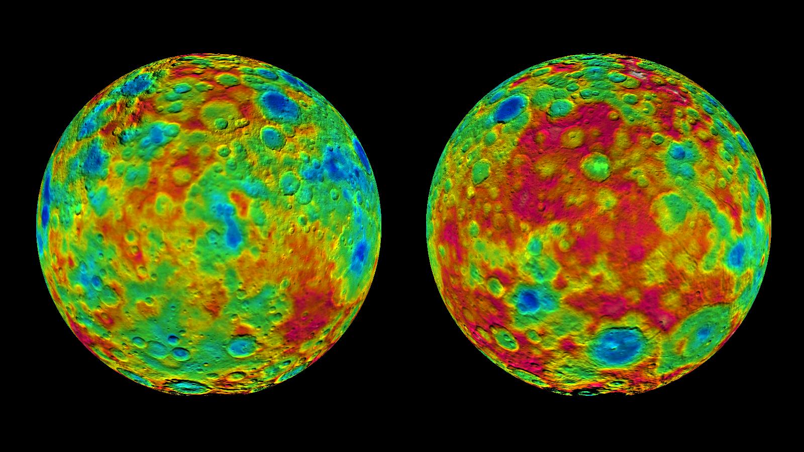
English: PIA19607: Topographic Maps of Ceres' East and West Hemispheres
http://photojournal.jpl.nasa.gov/catalog/PIA19607 This pair of images shows color-coded maps from NASA's Dawn mission, revealing the highs and lows of topography on the surface of dwarf planet Ceres. The map at left is centered on terrain at 60 degrees east longitude; the map at right is centered on 240 degrees east longitude. The color scale extends about 5 miles (7.5 kilometers) below the surface in indigo to 5 miles (7.5 kilometers) above the surface in red. The topographic map was constructed from analyzing images from Dawn's framing camera taken from varying sun and viewing angles. The map was combined with an image mosaic of Ceres and projected as an orthographic projection. The well-known bright spots in the center of Ceres northern hemisphere in the image at right retain their bright appearance, although they are color-coded in the same green elevation of the crater floor in which they sit. Note: The elevation scale used for this topographic map product differs slightly from the scale used to create PIA19605. These are preliminary data products; the Dawn science team may revisit the data to standardize the scale at a later date. PIA19605. These are preliminary data products; the Dawn science team may revisit the data to standardize the scale at a later date. Dawn's mission is managed by JPL for NASA's Science Mission Directorate in Washington. Dawn is a project of the directorate's Discovery Program, managed by NASA's Marshall Space Flight Center in Huntsville, Alabama. UCLA is responsible for overall Dawn mission science. Orbital ATK, Inc., in Dulles, Virginia, designed and built the spacecraft. The German Aerospace Center, the Max Planck Institute for Solar System Research, the Italian Space Agency and the Italian National Astrophysical Institute are international partners on the mission team. For a complete list of acknowledgments, see http://dawn.jpl.nasa.gov/mission. For more information about the Dawn mission, visit http://dawn.jpl.nasa.gov. |
| 日期 | |
| 來源 | NASA/JPL-Caltech/UCLA/MPS/DLR/IDA |
| 作者 | http://photojournal.jpl.nasa.gov/jpeg/PIA19607.jpg |
授權條款
[編輯]
| 本作品由NASA創作,屬於公有領域。根據NASA的版權政策:“NASA的創作除非另有聲明否則不受版權保護。”(參見:Template:PD-USGov/zh,NASA版權政策或JPL圖像使用政策) | ||
 |
警告:
|
檔案歷史
點選日期/時間以檢視該時間的檔案版本。
| 日期/時間 | 縮圖 | 尺寸 | 用戶 | 備註 | |
|---|---|---|---|---|---|
| 目前 | 2015年7月28日 (二) 18:32 | | 1,600 × 900(196 KB) | Drbogdan(對話 | 貢獻) | User created page with UploadWizard |
無法覆蓋此檔案。
檔案用途
沒有使用此檔案的頁面。
全域檔案使用狀況
以下其他 wiki 使用了這個檔案:
- en.wikiversity.org 的使用狀況
- fa.wikipedia.org 的使用狀況
- fr.wikipedia.org 的使用狀況
- hu.wikipedia.org 的使用狀況
- ja.wikipedia.org 的使用狀況
- pl.wikipedia.org 的使用狀況
- zh.wikipedia.org 的使用狀況