File:PIA19625-CeresMap-CraterNames-20150817.jpg
原始文件 (3,168 × 1,686像素,文件大小:691 KB,MIME类型:image/jpeg)
说明
说明
摘要[编辑]
| 描述 |
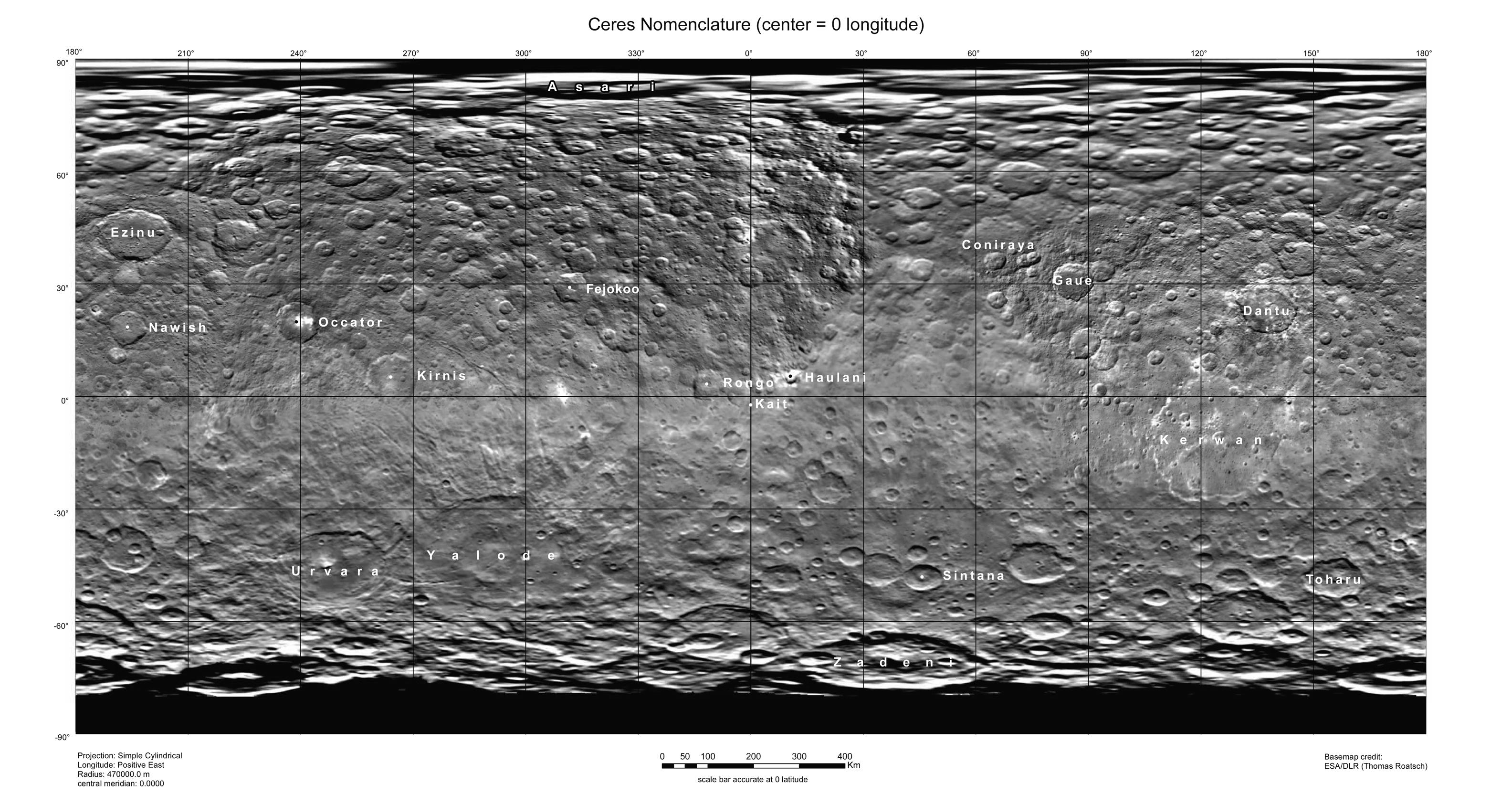
English: PIA19625: Ceres Map With Crater Names -- August 2015
http://photojournal.jpl.nasa.gov/catalog/PIA19625 This map of Ceres, constructed from data collected by NASA's Dawn spacecraft, shows the dwarf planet's surface with features that have been named as of August 14, 2015. This is a simple cylindrical projection centered on 0 degrees east longitude, created by science team members at the German Aerospace Center (DLR). The most recently named feature is the small crater Kait, after the Hattic goddess of grain. It is a mere 0.2 miles (0.4 kilometers) across. A full list of crater names on Ceres is available at http://planetarynames.wr.usgs.gov/SearchResults%3Ftarget=CERES. Dawn's mission is managed by JPL for NASA's Science Mission Directorate in Washington. Dawn is a project of the directorate's Discovery Program, managed by NASA's Marshall Space Flight Center in Huntsville, Alabama. UCLA is responsible for overall Dawn mission science. Orbital ATK, Inc., in Dulles, Virginia, designed and built the spacecraft. The German Aerospace Center, the Max Planck Institute for Solar System Research, the Italian Space Agency and the Italian National Astrophysical Institute are international partners on the mission team. For a complete list of acknowledgments, see http://dawn.jpl.nasa.gov/mission. For more information about the Dawn mission, visit http://dawn.jpl.nasa.gov. |
| 日期 | |
| 来源 | http://photojournal.jpl.nasa.gov/jpeg/PIA19625.jpg |
| 作者 | NASA/JPL-Caltech/UCLA/MPS/DLR/IDA |
许可协议[编辑]
| 本文件完全由NASA创作,在美国属于公有领域。根据NASA的版权方针,NASA的材料除非另有声明否则不受版权保护。(参见Template:PD-USGov/zh、NASA版权方针页面或JPL图片使用方针。) | ||
 |
警告:
|
文件历史
点击某个日期/时间查看对应时刻的文件。
| 日期/时间 | 缩略图 | 大小 | 用户 | 备注 | |
|---|---|---|---|---|---|
| 当前 | 2015年8月17日 (一) 19:39 | | 3,168 × 1,686(691 KB) | Drbogdan(留言 | 贡献) | User created page with UploadWizard |
您不可以覆盖此文件。
文件用途
没有页面使用本文件。
全域文件用途
以下其他wiki使用此文件:
- fa.wikipedia.org上的用途
- fr.wikipedia.org上的用途
- ja.wikipedia.org上的用途
- ta.wikipedia.org上的用途
- zh.wikipedia.org上的用途