File:PIA19657-SaturnMoon-Titan-NorthPole-20140407.jpg

元のファイル (3,208 × 3,208 ピクセル、ファイルサイズ: 2.21メガバイト、MIME タイプ: image/jpeg)
キャプション
キャプション
概要
[編集]
| 解説 |
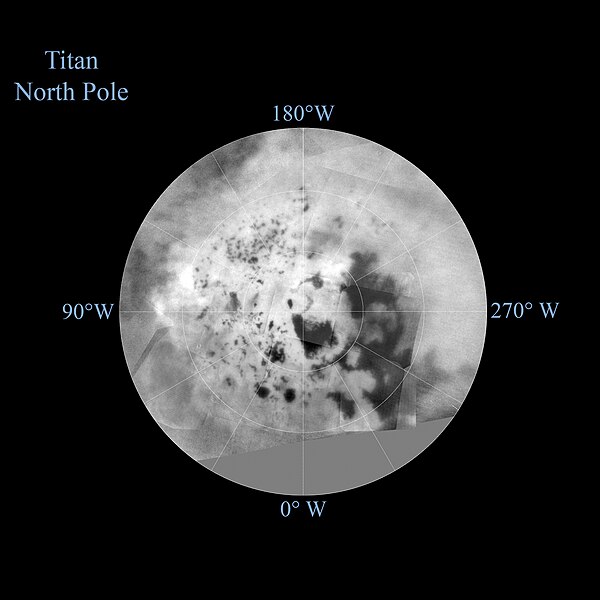
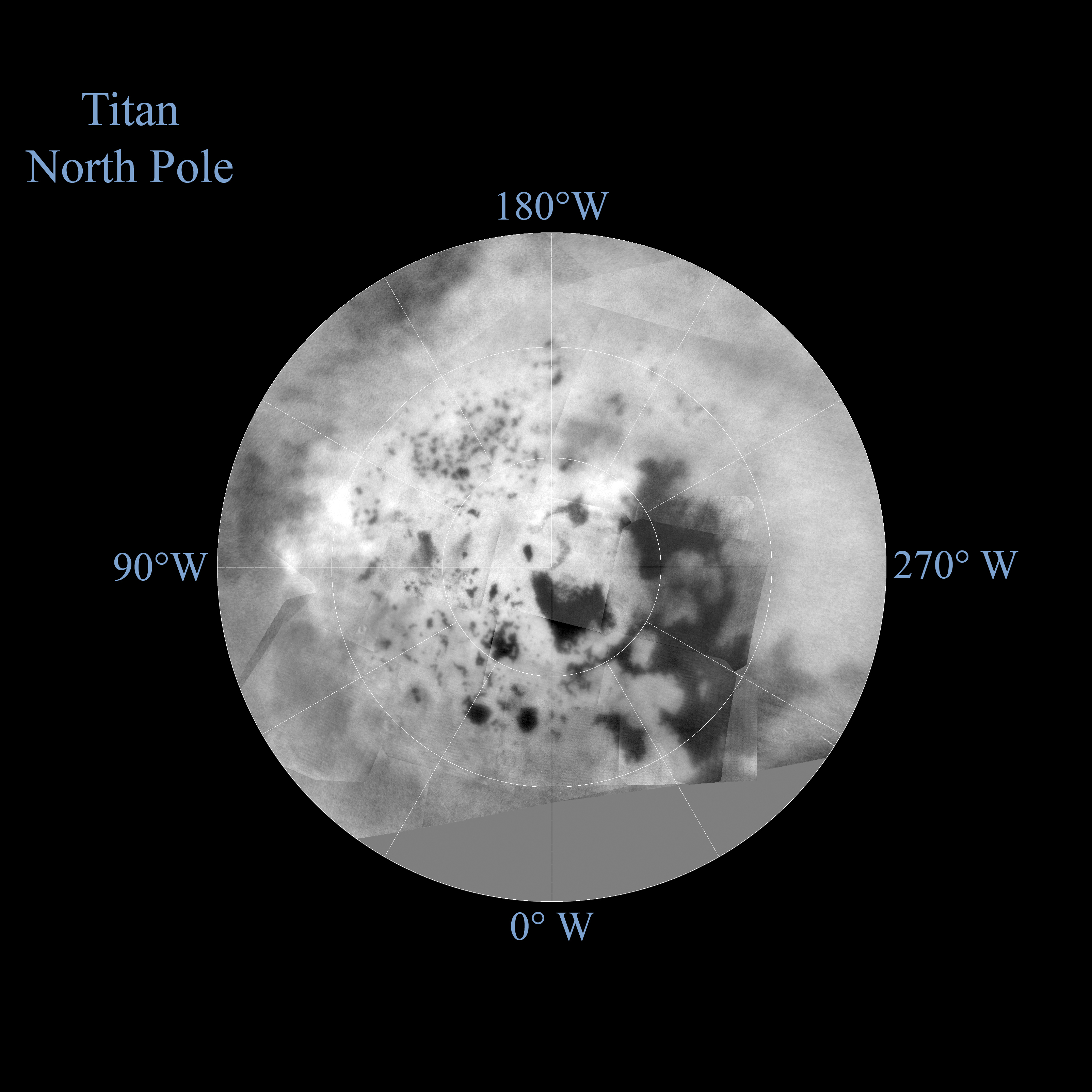
English: PIA19657: Titan Polar Maps - 2015 - North Pole
http://photojournal.jpl.nasa.gov/catalog/PIA19657 The northern and southern hemispheres of Titan are seen in these polar stereographic maps, assembled in 2015 using the best-available images of the giant Saturnian moon from NASA's Cassini mission. The images were taken by Cassini's imaging cameras using a spectral filter centered at 938 nanometers, allowing researchers to examine variations in albedo (or inherent brightness) across the surface of Titan. These maps utilize imaging data collected through Cassini's flyby on April 7, 2014, known as "T100." Titan's north pole was not well illuminated early in Cassini's mission, because it was winter in the northern hemisphere when the spacecraft arrived at Saturn. Cassini has been better able to observe northern latitudes in more recent years due to seasonal changes in solar illumination. Compared to the previous version of Cassini's north polar map (see PIA11146), this map provides much more detail and fills in a large area of missing data. The imaging data in these maps complement Cassini synthetic aperture radar (SAR) mapping of Titan's north pole (see PIA17655). The uniform gray area in the northern hemisphere indicates a gap in the imaging coverage of Titan's surface, to date. The missing data will be imaged by Cassini during flybys on December 15, 2016 and March 5, 2017. Lakes are also seen in the southern hemisphere map, but they are much less common than in the north polar region. Only a lakes have been confirmed in the south. The dark, footprint-shaped feature at 180 degrees west is Ontario Lacus; a smaller lake named Crveno Lacus can be seen as a very dark spot just above Ontario. The dark-albedo area seen at the top of the southern hemisphere map (at 0 degrees west) is an area called Mezzoramia. Each map is centered on one of the poles, and surface coverage extends southward to 60 degrees latitude. Grid lines indicate latitude in 10-degree increments and longitude in 30-degree increments. The scale in the full-size versions of these maps is 4,600 feet (1,400 meters) per pixel. The mean radius of Titan used for projection of these maps is 1,600 miles (2,575 kilometers). The Cassini mission is a cooperative project of NASA, ESA (the European Space Agency) and the Italian Space Agency. The Jet Propulsion Laboratory, a division of the California Institute of Technology in Pasadena, manages the mission for NASA's Science Mission Directorate, Washington. The Cassini orbiter and its two onboard cameras were designed, developed and assembled at JPL. The imaging operations center is based at the Space Science Institute in Boulder, Colorado. For more information about the Cassini-Huygens mission visit http://saturn.jpl.nasa.gov and http://www.nasa.gov/cassini. The Cassini imaging team homepage is at http://ciclops.org. |
| 日付 | |
| 原典 | http://photojournal.jpl.nasa.gov/figures/PIA19657_fig2.jpg |
| 作者 | NASA/JPL-Caltech/Space Science Institute |
ライセンス
[編集]
| このファイルはアメリカ航空宇宙局(NASA)によって作成されたものです。NASAの著作権の方針では、特記事項が無い場合、NASAの資料はパブリックドメインとなります。 (詳しくはTemplate:PD-USGov、NASAの著作権の方針について(英語)又はジェット推進研究所(JPL)の画像使用に関するガイドライン(英語)をご覧ください。) |
||
 |
注意事項:
|
ファイルの履歴
過去の版のファイルを表示するには、その版の日時をクリックしてください。
| 日付と時刻 | サムネイル | 寸法 | 利用者 | コメント | |
|---|---|---|---|---|---|
| 現在の版 | 2015年10月9日 (金) 21:54 | | 3,208 × 3,208 (2.21メガバイト) | Drbogdan (トーク | 投稿記録) | User created page with UploadWizard |
このファイルは上書きできません。
ファイルの使用状況
このファイルを使用しているページはありません。
グローバルなファイル使用状況
以下に挙げる他のウィキがこの画像を使っています:
- af.wikipedia.org での使用状況
- an.wikipedia.org での使用状況
- ar.wikipedia.org での使用状況
- cs.wikipedia.org での使用状況
- en.wikipedia.org での使用状況
- hy.wikipedia.org での使用状況
- ja.wikipedia.org での使用状況
- mk.wikipedia.org での使用状況
- pl.wikipedia.org での使用状況
- zh.wikipedia.org での使用状況