File:PIA19858-Pluto-NewHorizons-GridVersion-20150714-0727.jpg

Fichier d’origine (8 000 × 4 000 pixels, taille du fichier : 2,35 Mio, type MIME : image/jpeg)
Légendes
Légendes
Description
[modifier]
| Description |
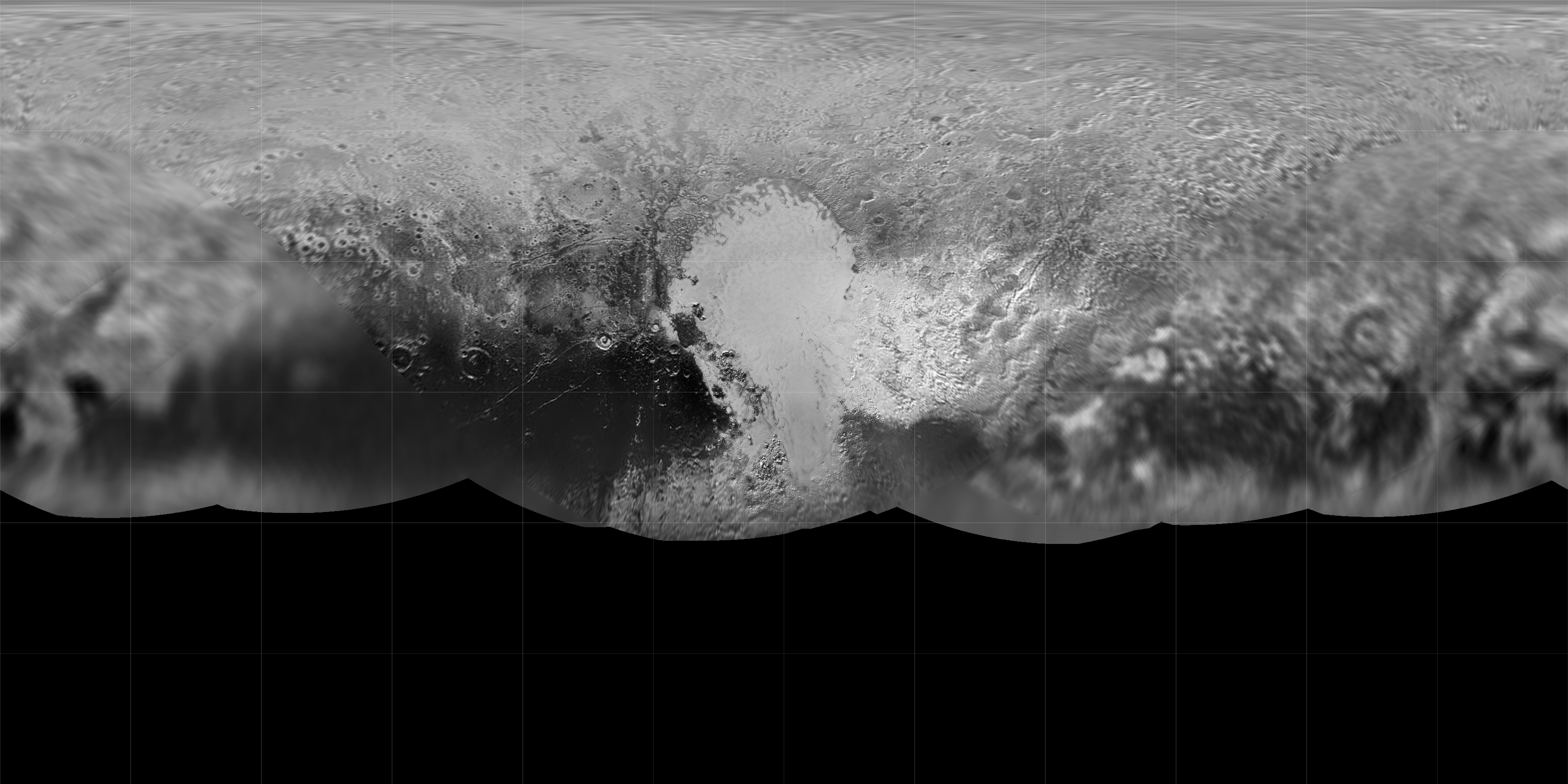
English: PIA19858: Global Map of Pluto
http://photojournal.jpl.nasa.gov/catalog/PIA19858 The science team of NASA's New Horizons mission has produced an updated global map of the dwarf planet Pluto. The map includes all resolved images of the surface acquired between July 7-14, 2015, at pixel resolutions ranging from 40 kilometers (24 miles) on the Charon-facing hemisphere (left and right sides of the map) to 400 meters (1,250 feet) on the anti-Charon facing hemisphere (map center). Many additional images are expected in fall of 2015 and these will be used to complete the global map. The New Horizons spacecraft flew past Pluto and its moons on July 14. The Johns Hopkins University Applied Physics Laboratory in Laurel, Maryland, designed, built, and operates the New Horizons spacecraft, and manages the mission for NASA's Science Mission Directorate. SwRI, based in San Antonio, leads the science team, payload operations and encounter science planning. New Horizons is part of the New Frontiers Program managed by NASA's Marshall Space Flight Center in Huntsville, Alabama. |
| Date | |
| Source | http://photojournal.jpl.nasa.gov/figures/PIA19858_fig1.jpg |
| Auteur | NASA/Johns Hopkins University Applied Physics Laboratory/Southwest Research Institute |
Conditions d’utilisation
[modifier]
| Ce fichier provient de la NASA. Sauf exception, les documents créés par la NASA ne sont pas soumis à copyright. Pour plus d'informations, voir la politique de copyright de la NASA. | ||
 |
Attention :
|
Historique du fichier
Cliquer sur une date et heure pour voir le fichier tel qu'il était à ce moment-là.
| Date et heure | Vignette | Dimensions | Utilisateur | Commentaire | |
|---|---|---|---|---|---|
| actuel | 28 juillet 2015 à 17:38 | | 8 000 × 4 000 (2,35 Mio) | Drbogdan (d | contributions) | User created page with UploadWizard |
Vous ne pouvez pas remplacer ce fichier.
Utilisations locales du fichier
La page suivante utilise ce fichier :
- File:Map of Pluto PS723 HR-g.jpg (redirection de fichier)
Utilisations du fichier sur d’autres wikis
Les autres wikis suivants utilisent ce fichier :
- Utilisation sur af.wikipedia.org
- Utilisation sur en.wikipedia.org
- Utilisation sur fr.wikipedia.org
- Utilisation sur it.wikipedia.org
- Tombaugh Regio
- Tartarus Dorsa
- Sputnik Planitia
- Adlivun Cavus
- Al-Idrisi Montes
- Hillary Montes
- Tenzing Montes
- Djanggawul Fossae
- Sleipnir Fossa
- Virgil Fossae
- Hayabusa Terra
- Voyager Terra
- Cratere Burney
- Cratere Elliot
- Baret Montes
- Hekla Cavus
- Cthulhu Macula
- Alcyonia Lacus
- Lowell Regio
- Cratere Khare
- Cratere Kiladze
- Cratere Simonelli
- Mwindo Fossae
- Piri Rupes
- Hunahpu Valles
- Venera Terra
- Vega Terra
- Wright Mons
- Pigafetta Montes
- Piccard Mons
- Elcano Montes
- Kaknù Fossa
- Hermod Fossae
- Tabei Montes
- Uncama Fossa
- Hyecho Palus
- Cratere Coughlin
- Cratere Hardie
- Cratere Zagar
- Cratere Pulfrich
- Cratere Hardaway
- Pioneer Terra
- Viking Terra
- Lunokhod Planitia
- Ranger Planitia
- Zheng He Montes
- Beatrice Fossa
Voir davantage sur l’utilisation globale de ce fichier.