File:PIA20188-Ceres-DwarfPlanet-Dawn-4thMapOrbit-LAMO-image5-20151210e-color.jpg

元のファイル (1,024 × 1,024 ピクセル、ファイルサイズ: 304キロバイト、MIME タイプ: image/jpeg)
キャプション
キャプション
概要[編集]
| 解説 |
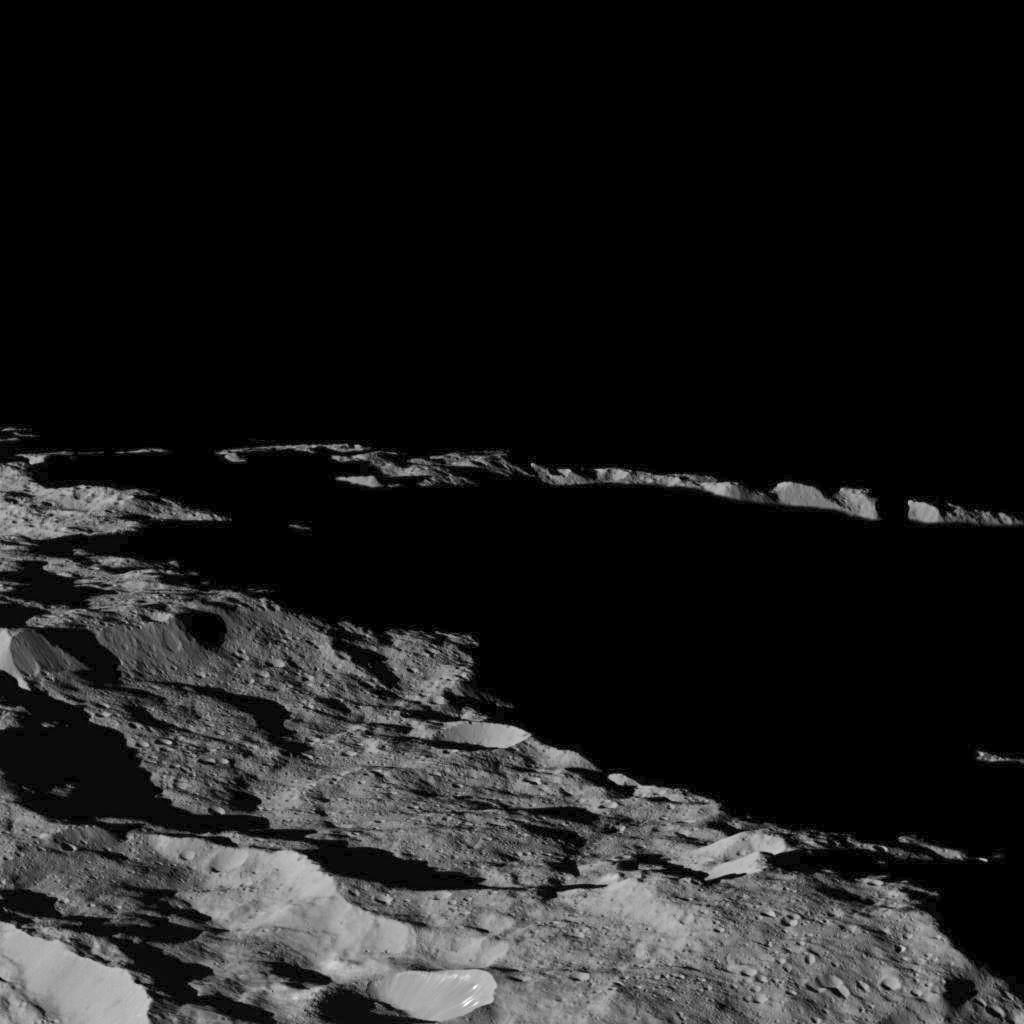
English: PIA20188: Dawn's Lowest Orbit: Near South Pole - Image 5/Image e
http://photojournal.jpl.nasa.gov/catalog/PIA20188 This view of Ceres, taken by NASA's Dawn spacecraft on December 10, 2015 shows an area in southern hemisphere of the dwarf planet. It is located at approximately 85.6 south longitude (latitude?), 176.6 east longitude. This part of Ceres, near the south pole, has such long shadows because, from the perspective of this location, the sun is near the horizon. At the time this image was taken, the sun was 4 degrees north of the equator. If you were standing this close to Ceres' south pole, the sun would never get high in the sky during the course of a nine-hour Cerean day. The spacecraft took this image in its low-altitude mapping orbit from an approximate distance of 240 miles (385 kilometers) from Ceres. Dawn's mission is managed by JPL for NASA's Science Mission Directorate in Washington. Dawn is a project of the directorate's Discovery Program, managed by NASA's Marshall Space Flight Center in Huntsville, Alabama. UCLA is responsible for overall Dawn mission science. Orbital ATK, Inc., in Dulles, Virginia, designed and built the spacecraft. The German Aerospace Center, the Max Planck Institute for Solar System Research, the Italian Space Agency and the Italian National Astrophysical Institute are international partners on the mission team. For a complete list of acknowledgments, see http://dawn.jpl.nasa.gov/mission. For more information about the Dawn mission, visit http://dawn.jpl.nasa.gov. |
| 日付 | |
| 原典 | http://photojournal.jpl.nasa.gov/jpeg/PIA20188.jpg |
| 作者 | NASA/JPL-Caltech/UCLA/MPS/DLR/IDA |
この画像には画像編集が施されています。原本に対して次のデジタル的な変更が行われました。
|
ライセンス[編集]
| このファイルはアメリカ航空宇宙局(NASA)によって作成されたものです。NASAの著作権の方針では、特記事項が無い場合、NASAの資料はパブリックドメインとなります。 (詳しくはTemplate:PD-USGov、NASAの著作権の方針について(英語)又はジェット推進研究所(JPL)の画像使用に関するガイドライン(英語)をご覧ください。) |
||
 |
注意事項:
|
ファイルの履歴
過去の版のファイルを表示するには、その版の日時をクリックしてください。
| 日付と時刻 | サムネイル | 寸法 | 利用者 | コメント | |
|---|---|---|---|---|---|
| 現在の版 | 2016年8月27日 (土) 00:08 | | 1,024 × 1,024 (304キロバイト) | PlanetUser (トーク | 投稿記録) | =={{int:filedesc}}== {{Information |description={{en|1=PIA20188: Dawn's Lowest Orbit: Near South Pole - Image 5/Image e http://photojournal.jpl.nasa.gov/catalog/PIA20188 This view of Ceres, taken by NASA's Dawn spacecraft on December 10, 2015 shows a... |
このファイルは上書きできません。
ファイルの使用状況
以下のページがこのファイルを使用しています:
グローバルなファイル使用状況
以下に挙げる他のウィキがこの画像を使っています:
- ja.wikipedia.org での使用状況