File:PIA23514-Mars-WaterIce-LikeliestAreas-20191210.jpg
跳转到导航
跳转到搜索

本预览的尺寸:800 × 357像素。 其他分辨率:320 × 143像素 | 640 × 286像素 | 1,614 × 720像素。
原始文件 (1,614 × 720像素,文件大小:304 KB,MIME类型:image/jpeg)
说明
说明
添加一行文字以描述该文件所表现的内容
Mars - Water Ice - Likeliest Areas - December 10, 2019
摘要[编辑]
| 描述 |
English: A Water Ice Map for Mars
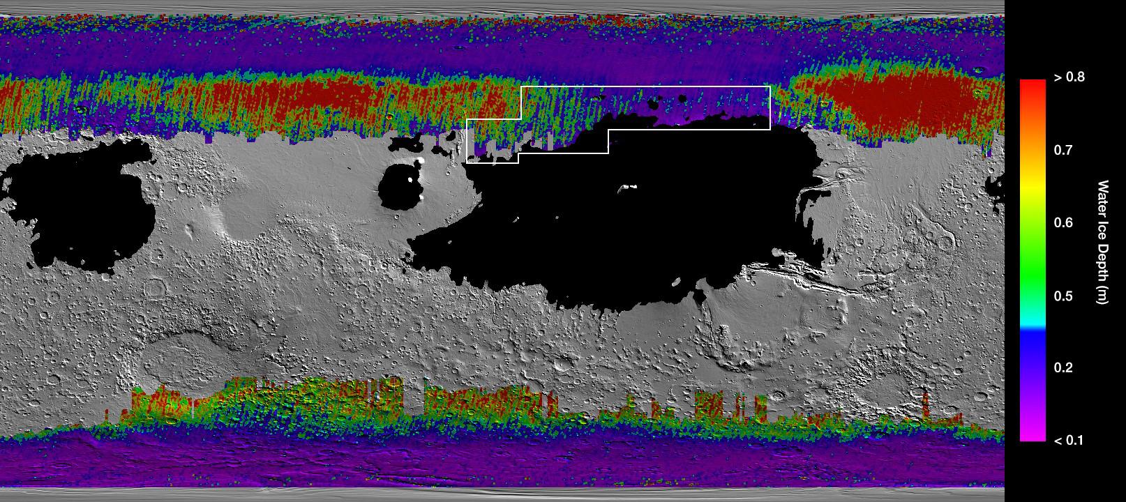
https://www.jpl.nasa.gov/spaceimages/details.php?id=PIA23514 This rainbow-colored map shows underground water ice on Mars. This rainbow-colored map shows underground water ice on Mars. Cool colors represent less than one foot (30 centimeters) below the surface; warm colors are over two feet (60 centimeters) deep. Sprawling black zones on the map represent areas where a landing spacecraft would sink into fine dust. The outlined box represents the ideal region to send astronauts for them to be able to dig up water ice. The map was created by combining data from multiple NASA orbiters, including the Mars Reconnaissance Orbiter and its Mars Climate Sounder instrument; Mars Odyssey and its Thermal Emission Imaging System; and the Mars Global Surveyor. |
| 日期 | |
| 来源 | https://photojournal.jpl.nasa.gov/jpeg/PIA23514.jpg |
| 作者 | NASA/JPL-Caltech/ASU |
许可协议[编辑]
| 本文件完全由NASA创作,在美国属于公有领域。根据NASA的版权方针,NASA的材料除非另有声明否则不受版权保护。(参见Template:PD-USGov/zh、NASA版权方针页面或JPL图片使用方针。) | ||
 |
警告:
|
文件历史
点击某个日期/时间查看对应时刻的文件。
| 日期/时间 | 缩略图 | 大小 | 用户 | 备注 | |
|---|---|---|---|---|---|
| 当前 | 2019年12月11日 (三) 00:53 | | 1,614 × 720(304 KB) | Drbogdan(留言 | 贡献) | User created page with UploadWizard |
您不可以覆盖此文件。
文件用途
没有页面使用本文件。
全域文件用途
以下其他wiki使用此文件:
- bn.wikipedia.org上的用途
- de.wikipedia.org上的用途
- en.wikipedia.org上的用途
- ro.wikipedia.org上的用途
- zh.wikipedia.org上的用途