File:PNW-straits.jpg
Salta a la navegació
Salta a la cerca
No hi ha cap versió amb una resolució més gran.
PNW-straits.jpg (336 × 396 píxels, mida del fitxer: 128 Ko, tipus MIME: image/jpeg)
Llegendes
Llegendes
Afegeix una explicació d'una línia del que representa aquest fitxer
Resum[modifica]
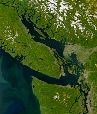
| Descripció | Satellite image of the Strait of Georgia, Strait of Juan de Fuca, and surrounding region. The image was acquired by the Sea-viewing Wide Field-of-view Sensor (SeaWiFS) on August 9, 2001. Original image cropped to highlight the Strait of Georgia. |
| Data | |
| Font | NASAEarth Observatory, http://earthobservatory.nasa.gov/Newsroom/NewImages/images.php3?img_id=5051 |
| Autor | The SeaWiFS Project, NASA/Goddard Space Flight Center, and ORBIMAGE |
Llicència[modifica]
| This image is from the Sea-viewing Wide Field-of-view Sensor (SeaWiFS) Project and more than 5 years old.
Satellite data captured by the SeaWIFS sensor are released into the public domain 5 years after capture. Data less than five years old can be re-used only for educational or scientific purposes; any commercial use of such images must be coordinated with GeoEye. [1] |
| This work has been released into the public domain by its copyright holder, GeoEye. This applies worldwide. En alguns països això pot no ser legalment possible, en tal cas: GeoEye concedeix a tothom el dret d'usar aquesta obra per a qualsevol propòsit, sense cap condició llevat d'aquelles requerides per la llei.
|
Historial del fitxer
Cliqueu una data/hora per veure el fitxer tal com era aleshores.
| Data/hora | Miniatura | Dimensions | Usuari/a | Comentari | |
|---|---|---|---|---|---|
| actual | 06:55, 22 abr 2008 | | 336 × 396 (128 Ko) | Pfly (discussió | contribucions) | {{Information |Description=Satellite image of the Strait of Georgia, Strait of Juan de Fuca, and surrounding region. The image was acquired by the Sea-viewing Wide Field-of-view Sensor (SeaWiFS) on |
No podeu sobreescriure aquest fitxer.
Ús del fitxer
La pàgina següent utilitza aquest fitxer:
Ús global del fitxer
Utilització d'aquest fitxer en altres wikis:
- Utilització a ar.wikipedia.org
- Utilització a ast.wikipedia.org
- Utilització a az.wikipedia.org
- Utilització a br.wikipedia.org
- Utilització a ca.wikipedia.org
- Utilització a cv.wikipedia.org
- Utilització a de.wikipedia.org
- Utilització a en.wikipedia.org
- Utilització a eo.wikipedia.org
- Utilització a es.wikipedia.org
- Utilització a fa.wikipedia.org
- Utilització a fi.wikipedia.org
- Utilització a fr.wikipedia.org
- Utilització a fr.wiktionary.org
- Utilització a fy.wikipedia.org
- Utilització a he.wikipedia.org
- Utilització a id.wikipedia.org
- Utilització a is.wikipedia.org
- Utilització a it.wikipedia.org
- Utilització a ja.wikipedia.org
- Utilització a ko.wikipedia.org
- Utilització a lv.wikipedia.org
- Utilització a mhr.wikipedia.org
- Utilització a mk.wikipedia.org
- Utilització a ms.wikipedia.org
- Utilització a nl.wikipedia.org
- Utilització a no.wikipedia.org
- Utilització a pl.wikipedia.org
- Utilització a pt.wikipedia.org
- Utilització a ru.wikipedia.org
- Utilització a sh.wikipedia.org
- Utilització a tr.wikipedia.org
- Utilització a uk.wikipedia.org
- Utilització a ur.wikipedia.org
- Utilització a vi.wikipedia.org
- Utilització a zh.wikipedia.org
Vegeu més usos globals d'aquest fitxer.
Metadades
Categories:
- SeaWiFS images
- Satellite pictures of Washington (state)
- Satellite pictures of British Columbia
- August 2001 Canada photographs
- 2001 in British Columbia
- August 2001 in Washington (state)
- 2001 satellite pictures
- Salish Sea
- Satellite pictures of Olympic National Park
- Coastline of Washington (state)
- Coastal sediment transport in British Columbia
- Coastal sediment transport in Washington (state)
- Satellite pictures of islands of Canada