File:Pac-12 Conference states.svg
跳转到导航
跳转到搜索

此SVG文件的PNG预览的大小:800 × 507像素。 其他分辨率:320 × 203像素 | 640 × 405像素 | 1,024 × 648像素 | 1,280 × 811像素 | 2,560 × 1,621像素 | 927 × 587像素。
原始文件 (SVG文件,尺寸为927 × 587像素,文件大小:67 KB)
说明
说明
添加一行文字以描述该文件所表现的内容
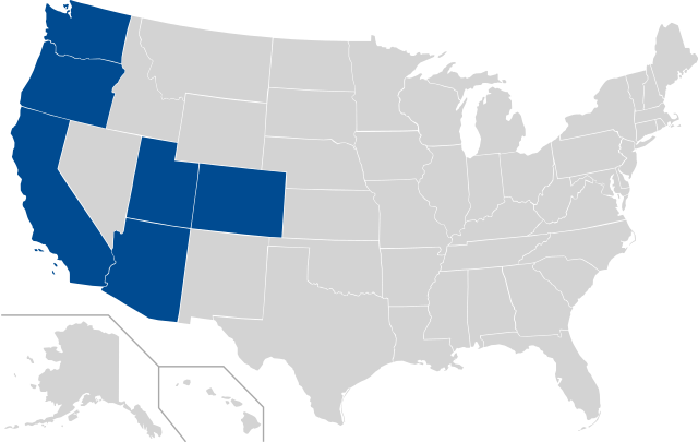
States included in NCAA PAC-12 Conference
Template:Pac-12 Conference Map.svg
| 描述 | This is a vectorized map of states with en:Pac-10 schools (and expansion schools); |
| 日期 | (UTC) |
| 来源 | Derived fromPac_10_USA_states.svg; map of states with en:Pac-10 schools |
| 作者 | derivative work: Pac_10_USA_states.svg |
| 这是一张修改过的图片,这意味着它已在原版本的基础上通过软件进行了编辑,改动内容:Added CO and UT。其原始版本为:Pac 10 USA states.svg。修改者:Bradwilkins。
|
我,本作品著作权人,特此采用以下许可协议发表本作品:
| 我,本作品著作权人,释出本作品至公有领域。这适用于全世界。 在一些国家这可能不合法;如果是这样的话,那么: 我无条件地授予任何人以任何目的使用本作品的权利,除非这些条件是法律规定所必需的。 |
原始上传日志
[编辑]
This image is a derivative work of the following images:
- File:Pac_10_USA_states.svg licensed with PD-self
- 2007-11-22T21:28:52Z Mcmillin24 1051x725 (123824 Bytes) {{Information |Description=This is a vectorized version of [[:en::Image:Pac_10_USA_states.png]] |Source=Derived from [[:en::Image:BlankMap-USA-states.PNG]]; map of states with [[:en:Pac-10]] schools (and their division); |Dat
Uploaded with derivativeFX
文件历史
点击某个日期/时间查看对应时刻的文件。
| 日期/时间 | 缩略图 | 大小 | 用户 | 备注 | |
|---|---|---|---|---|---|
| 当前 | 2024年8月4日 (日) 03:24 | | 927 × 587(67 KB) | Colohisto(留言 | 贡献) | Update |
| 2016年6月6日 (一) 00:05 |  | 927 × 587(67 KB) | Corkythehornetfan(留言 | 贡献) | fixed right side | |
| 2016年2月15日 (一) 01:26 |  | 959 × 593(81 KB) | Corkythehornetfan(留言 | 贡献) | remove some unneeded coding // Editing SVG source code using User:Rillke/SVGedit.js; upload handled by User:Rillke/MwJSBot.js | |
| 2016年2月13日 (六) 22:53 |  | 959 × 593(81 KB) | Corkythehornetfan(留言 | 贡献) | updated map to transparent/colors // Editing SVG source code using User:Rillke/SVGedit.js; upload handled by User:Rillke/MwJSBot.js | |
| 2011年7月1日 (五) 07:54 |  | 841 × 580(66 KB) | CASportsFan(留言 | 贡献) | Colorado and Utah are now full members. | |
| 2010年6月17日 (四) 04:37 |  | 841 × 580(66 KB) | Bradwilkins(留言 | 贡献) | {{Information |Description=This is a vectorized map of states with en:Pac-10 schools (and expansion schools); |Source=Derived fromFile:Pac_10_USA_states.svg; map of states with en:Pac-10 schools |Date=2010-06-17 04:28 (UTC) |Author=[[User:Bradwilkin |
您不可以覆盖此文件。
文件用途
以下页面使用本文件:
全域文件用途
以下其他wiki使用此文件:
- de.wikipedia.org上的用途
- en.wikipedia.org上的用途
- es.wikipedia.org上的用途
- fa.wikipedia.org上的用途
- fr.wikipedia.org上的用途
- it.wikipedia.org上的用途
- ja.wikipedia.org上的用途
- pl.wikipedia.org上的用途
- pt.wikipedia.org上的用途
- ru.wikipedia.org上的用途
- sv.wikipedia.org上的用途
- zh.wikipedia.org上的用途