File:Pacific Northwest River System.png
Перейти к навигации
Перейти к поиску

Размер этого предпросмотра: 569 × 599 пкс. Другие разрешения: 228 × 240 пкс | 456 × 480 пкс | 729 × 768 пкс | 973 × 1024 пкс | 1930 × 2032 пкс.
Исходный файл (1930 × 2032 пкс, размер файла: 412 КБ, MIME-тип: image/png)
Краткие подписи
Краткие подписи
Добавьте однострочное описание того, что собой представляет этот файл
Краткое описание
[править]
| Описание |
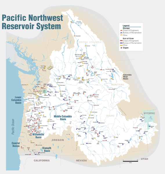
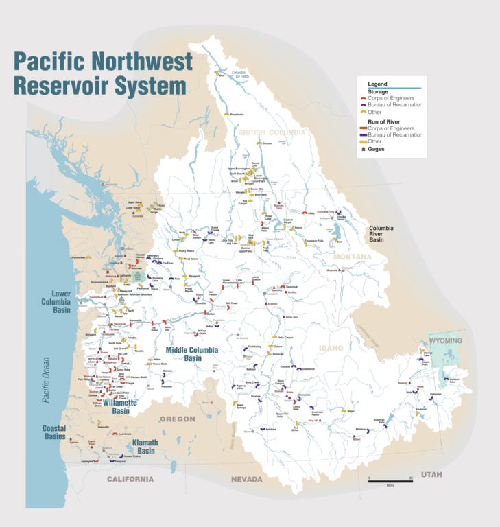
English: Maps of dams, drainage and estuaries along the Columbia River in North America (USA, Canada). Original caption: The Columbia River carved the Interior Columbia River Basin from the landscape of seven Western states and two Canadian provinces. The river itself flows from its headwaters in British Columbia, Canada through only two states, forming part of the Washington-Oregon border, the vast Interior Columbia River Basin is defined by the area drained by the river and its many tributaries. This 58-million-hectare area (about the size of France) extends roughly from the crest of the Cascade Mountains of Oregon and Washington east through Idaho to the Continental Divide in the Rocky Mountains of Montana and Wyoming, and from the headwaters of the Columbia River in Canada to the high desert of northern Nevada and northwestern Utah. |
| Дата | |
| Источник | Portland District Visual Information, U.S. Army Corps of Engineers |
| Автор | U.S. Army Corps of Engineers |
| Другие версии |
Производные работы от этого файла: Columbia.png |
Лицензирование
[править]
Это произведение является работой служащего или сотрудника Инженерных войск США, сделанной или полученной им в ходе исполнения должностных обязанностей. Будучи работой высших федеральных органов государственной власти США, произведение находится в общественном достоянии.
|
История файла
Нажмите на дату/время, чтобы увидеть версию файла от того времени.
| Дата/время | Миниатюра | Размеры | Участник | Примечание | |
|---|---|---|---|---|---|
| текущий | 22:31, 11 января 2010 | | 1930 × 2032 (412 КБ) | Spankston (обсуждение | вклад) | larger file, higher resolution |
| 21:56, 11 января 2010 |  | 914 × 963 (565 КБ) | Spankston (обсуждение | вклад) | {{Information |Description={{en|1=Maps of dams, drainage and estuaries along the Columbia River in North America (USA, Canada). Original caption: The Columbia River carved the Interior Columbia River Basin from the landscape of seven Western states a |
Вы не можете перезаписать этот файл.
Использование файла
Следующие 2 страницы используют этот файл:
Глобальное использование файла
Данный файл используется в следующих вики:
- Использование в bg.wikipedia.org
- Использование в de.wikipedia.org
- Использование в en.wikipedia.org
- Rocky Reach Dam
- Rock Island Dam
- Wanapum Dam
- Priest Rapids Dam
- Bonneville Dam
- Salmon River (Idaho)
- List of rivers of Washington (state)
- List of dams in the Columbia River watershed
- Revelstoke Dam
- The Dalles Dam
- Keenleyside Dam
- Columbia River Treaty
- Little Goose Dam
- Lower Granite Dam
- Lower Monumental Dam
- Ice Harbor Dam
- Dworshak Dam
- Palisades Dam
- Hells Canyon Dam
- Oxbow Dam
- Brownlee Dam
- Jackson Lake Dam
- C. J. Strike Dam
- Lake Cascade
- Deadwood Reservoir
- Lucky Peak Dam
- Arrowrock Dam
- Anderson Ranch Dam
- Zosel Dam
- User:Mdmunabbir/sandbox
- Использование в fi.wikipedia.org
- Использование в fr.wikipedia.org
- Использование в fy.wikipedia.org
- Использование в he.wikipedia.org
- Использование в it.wikipedia.org
- Использование в nl.wikipedia.org
- Использование в no.wikipedia.org
Просмотреть глобальное использование этого файла.