File:Pakistan Nationalhighways.PNG
Aller à la navigation
Aller à la recherche

Taille de cet aperçu : 625 × 600 pixels. Autres résolutions : 250 × 240 pixels | 500 × 480 pixels | 800 × 768 pixels | 1 067 × 1 024 pixels | 2 134 × 2 048 pixels | 3 256 × 3 125 pixels.
Fichier d’origine (3 256 × 3 125 pixels, taille du fichier : 1,09 Mio, type MIME : image/png)
Légendes
Légendes
Ajoutez en une ligne la description de ce que représente ce fichier

|
Cette image (de type carte) devrait être recréée dans un format vectoriel, en tant que fichier SVG. Cela offrirait plusieurs avantages : voir Commons:Media for cleanup pour plus d'informations. Si une version SVG de cette image est déjà disponible, merci de bien vouloir l'envoyer. Après cela, remplacez ce modèle par {{vector version available|nouveau nom d'image.svg}}.
|
Description[modifier]
| Description |
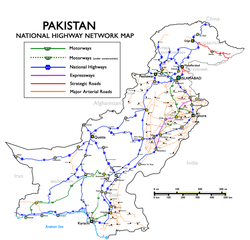
English: National Highways, Motorways & Strategic Roads in Pakistan. (Longest route N-5, from Karachi to Torkham, covering cities of Hyderabad, Multan, Lahore, Rawalpindi and Peshawar with a total length of 1,756 kilometers.) Русский: Схема национальных автодорог, автомагистралей и стратегических дорог Пакистана |
| Date | Uploaded in June 2009 by Nomi887; modified in July 2009 by Brainlara73. |
| Source | The English language Wikipedia. Original text: Self made using [1] and [2] as reference. |
| Auteur | Original text: nomi887 (talk) |
![[1]](http://www.daleelteq.com.pk/images/maps/Highway%20&%20Motorway%20Network%20of%20Pakistan.jpg)
Conditions d’utilisation[modifier]
Ce fichier est disponible selon les termes de la licence Creative Commons Attribution – Partage dans les Mêmes Conditions 3.0 (non transposée).
Attribution: Nomi887
- Vous êtes libre :
- de partager – de copier, distribuer et transmettre cette œuvre
- d’adapter – de modifier cette œuvre
- Sous les conditions suivantes :
- paternité – Vous devez donner les informations appropriées concernant l'auteur, fournir un lien vers la licence et indiquer si des modifications ont été faites. Vous pouvez faire cela par tout moyen raisonnable, mais en aucune façon suggérant que l’auteur vous soutient ou approuve l’utilisation que vous en faites.
- partage à l’identique – Si vous modifiez, transformez, ou vous basez sur cette œuvre, vous devez distribuer votre contribution sous la même licence ou une licence compatible avec celle de l’original.
Journal des téléversements d’origine[modifier]
All usernames refer to en:Wikipedia (log):
- 11:08, 7 July 2009 Brainlara73 uploaded a new version of "File:Pakistan Nationalhighways.PNG" 1,354×1,316 (246 KB) (Added some more locations in punjab.)
- 04:53, 17 June 2009 Nomi887 uploaded "File:Pakistan Nationalhighways.PNG" 1,354×1,316 (292 KB) ({{Information |Description = National Highways, Motorways & Strategic Roads in Pakistan |Source = Self made using [http://www.daleelteq.com.pk/images/maps/Highway%20&%20Motorway%20Network%20of%20Pakistan.jpg] and [http://www.nhmp.gov.pk/mapm.)
Historique du fichier
Cliquer sur une date et heure pour voir le fichier tel qu'il était à ce moment-là.
| Date et heure | Vignette | Dimensions | Utilisateur | Commentaire | |
|---|---|---|---|---|---|
| actuel | 1 janvier 2019 à 15:18 | | 3 256 × 3 125 (1,09 Mio) | Pakieditor (d | contributions) | Reverted to version as of 12:05, 26 June 2012 (UTC) |
| 1 janvier 2019 à 15:15 |  | 1 125 × 1 080 (553 kio) | Pakieditor (d | contributions) | More detailed map. | |
| 26 juin 2012 à 12:05 |  | 3 256 × 3 125 (1,09 Mio) | Nomi887 (d | contributions) | Corrected. | |
| 14 février 2011 à 09:51 |  | 1 354 × 1 316 (326 kio) | Nomi887 (d | contributions) | Minor corrections | |
| 14 février 2011 à 09:40 |  | 1 354 × 1 316 (325 kio) | Nomi887 (d | contributions) | Added Expressways & logos. | |
| 7 janvier 2010 à 00:00 |  | 1 354 × 1 316 (246 kio) | Guillaume70 (d | contributions) | {{Information |Description=National Highways, Motorways & Strategic Roads in Pakistan. (Longest route N-5, from Karachi to Torkham, covering cities of Hyderabad, Multan, Lahore, Rawalpindi and Peshawar with a total length of 1819 kilometers.) |Source=Wiki |
Vous ne pouvez pas remplacer ce fichier.
Utilisations locales du fichier
Les 2 pages suivantes utilisent ce fichier :
Utilisations du fichier sur d’autres wikis
Les autres wikis suivants utilisent ce fichier :
- Utilisation sur bn.wikipedia.org
- Utilisation sur cs.wikipedia.org
- Utilisation sur de.wikipedia.org
- Utilisation sur de.wikivoyage.org
- Utilisation sur en.wikipedia.org
- Transport in Pakistan
- Controlled-access highway
- Indus Highway
- National highways of Pakistan
- N-5 National Highway
- Motorways of Pakistan
- N-25 National Highway
- User:Nomi887
- Expressways of Pakistan
- N-50 National Highway
- N-30 National Highway
- N-40 National Highway
- N-45 National Highway
- N-65 National Highway
- N-70 National Highway
- N-75 National Highway
- N-85 National Highway
- N-80 National Highway
- N-90 National Highway
- N-95 National Highway
- N-105 National Highway
- N-110 National Highway
- N-120 National Highway
- N-125 National Highway
- N-155 National Highway
- N-255 National Highway
- N-305 National Highway
- N-455 National Highway
- N-655 National Highway
- Roads in Pakistan
- Template talk:Portal/Archive 8
- Utilisation sur en.wikivoyage.org
- Utilisation sur eo.wikipedia.org
Voir davantage sur l’utilisation globale de ce fichier.