File:Paleogeographic maps east Asia. Turgai Sea.jpg
跳转到导航
跳转到搜索

本预览的尺寸:327 × 599像素。 其他分辨率:131 × 240像素 | 262 × 480像素 | 900 × 1,649像素。
原始文件 (900 × 1,649像素,文件大小:100 KB,MIME类型:image/jpeg)
说明
说明
添加一行文字以描述该文件所表现的内容
摘要
[编辑]
| 描述 |
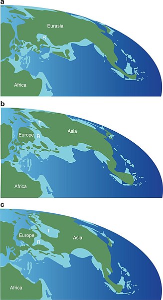
English: Paleogeographic maps showing the formation and disappearance of an epicontinental seaway between Europe and Central Asia during the Middle Jurassic through Early Cretaceous. a Middle Jurassic (170 Ma); b Late Jurassic (160 Ma); c Early Cretaceous (138 Ma). The maps are based on ref. 48. Green indicates land, light blue shallow sea, and deep blue ocean. Abbreviations: R, Russian Platform Sea; T, Turgai Sea |
| 日期 | |
| 来源 | https://www.nature.com/articles/s41467-018-05128-1 |
| 作者 | Xing Xu, Paul Upchurch, Philip D. Mannion, Paul M. Barrett, Omar R. Regalado-Fernandez, Jinyou Mo, Jinfu Ma & Hongan Liu |
许可协议
[编辑]
文件历史
点击某个日期/时间查看对应时刻的文件。
| 日期/时间 | 缩略图 | 大小 | 用户 | 备注 | |
|---|---|---|---|---|---|
| 当前 | 2018年8月1日 (三) 16:08 | | 900 × 1,649(100 KB) | Levi bernardo(留言 | 贡献) | User created page with UploadWizard |
您不可以覆盖此文件。
文件用途
没有页面使用本文件。
全域文件用途
以下其他wiki使用此文件:
- es.wikipedia.org上的用途
- zh.wikipedia.org上的用途