File:Palestine recognition only.svg
跳至導覽
跳至搜尋

此 SVG 檔案的 PNG 預覽的大小:800 × 411 像素。 其他解析度:320 × 164 像素 | 640 × 329 像素 | 1,024 × 526 像素 | 1,280 × 657 像素 | 2,560 × 1,314 像素。
原始檔案 (SVG 檔案,表面大小:2,560 × 1,314 像素,檔案大小:1.2 MB)
說明
說明
添加單行說明來描述出檔案所代表的內容
Palestine recognition
摘要[編輯]
| 描述 |
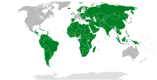
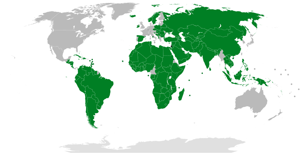
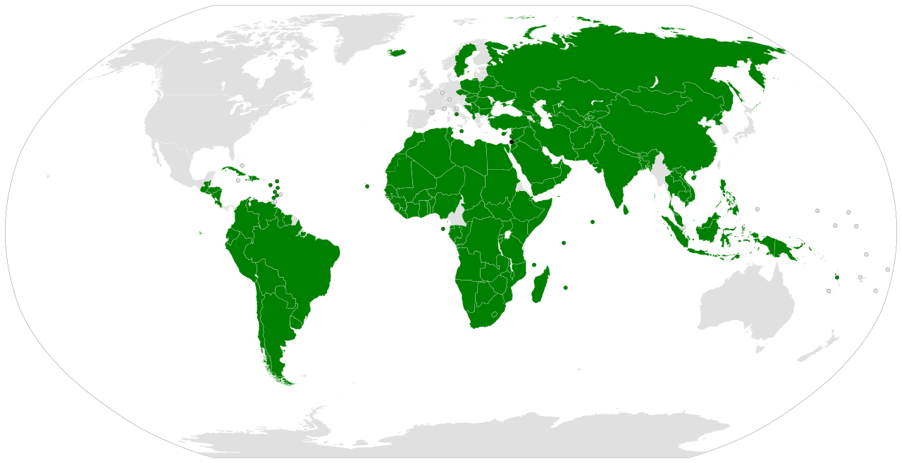
English: Dark green: States that recognise the State of Palestine. Based on sources compiled at International recognition of the State of Palestine.
فارسی: سبز تیره: دولتهایی که دولت فلسطین را به رسمیت میشناسند. بر پایهٔ منبعهای گردآوریشده در رسمیت بینالمللی دولت فلسطین.
日本語: 緑色: パレスチナを国家承認している国
한국어: 녹색: 팔레스타인을 인정하는 국가들
Română: Cu verde închis, țările care recunosc statul Palestina. Hartă alcătuită pe baza surselor citate în articolul Recunoașterea internațională a statului Palestina.
Українська: Темно-зеленим кольором позначені країни, які визнають державу Палестина.
العربية: الدول المظللة بالأخضر الداكن على الخريطة: هي الدول التي تعترف بدولة فلسطين. بناء على مصادر جمعت من الاعتراف الدولي بدولة فلسطين.
Español: Verde oscuro: Estados que reconocen el Estado de Palestina. Basado en fuentes recopiladas en Reconocimiento internacional de Palestina.
Euskara: Berde iluna: Palestinako Estatua errekonozitzen duten estatuak. Palestinako Estatuaren nazioarteko aintzatespena erreferentzian bildutako iturrietan oinarritua. |
| 日期 | |
| 來源 | |
| 作者 | Night w |
| 其他版本 |
|


授權條款[編輯]
| 此地圖不符合著作權的資格,因此屬於公有領域,因為其完全包含公共財產資訊,不包含原作者身份。詳情參見Commons:Threshold of originality § Maps。
|
檔案歷史
點選日期/時間以檢視該時間的檔案版本。
| 日期/時間 | 縮圖 | 尺寸 | 用戶 | 備註 | |
|---|---|---|---|---|---|
| 目前 | 2024年5月22日 (三) 08:15 | | 2,560 × 1,314(1.2 MB) | Underdwarf58(對話 | 貢獻) | Reverted to version as of 01:41, 20 May 2024 (UTC) it will take effect on May 28 https://www.cbsnews.com/news/ireland-spain-norway-recognizing-palestinian-state/ |
| 2024年5月22日 (三) 07:48 |  | 2,560 × 1,314(1.2 MB) | Gorgonopsi(對話 | 貢獻) | More Recognition | |
| 2024年5月20日 (一) 01:41 |  | 2,560 × 1,314(1.2 MB) | Underdwarf58(對話 | 貢獻) | Minor fixes in the Belgian-Dutch-French border and naming | |
| 2024年5月15日 (三) 15:05 |  | 2,560 × 1,314(1.2 MB) | Underdwarf58(對話 | 貢獻) | Noticed a color difference, whoops | |
| 2024年5月15日 (三) 04:15 |  | 2,560 × 1,314(1.2 MB) | Underdwarf58(對話 | 貢獻) | AB SKN fix (this map labels them as SB by mistake) | |
| 2024年5月8日 (三) 04:13 |  | 2,560 × 1,314(1.2 MB) | Underdwarf58(對話 | 貢獻) | Forgot to remove one island in SB | |
| 2024年5月8日 (三) 03:50 |  | 2,560 × 1,314(1.2 MB) | Underdwarf58(對話 | 貢獻) | %Saint Barthelemy | |
| 2024年5月8日 (三) 01:23 |  | 2,560 × 1,314(1.2 MB) | ReiPeixe(對話 | 貢獻) | + Bahamas recognized Palestine | |
| 2024年5月7日 (二) 09:23 |  | 2,560 × 1,314(1.2 MB) | Underdwarf58(對話 | 貢獻) | Netherlands fix | |
| 2024年5月7日 (二) 05:22 |  | 2,560 × 1,314(1.2 MB) | Underdwarf58(對話 | 貢獻) | Added a circle to represent Kosovo |
無法覆蓋此檔案。
檔案用途
全域檔案使用狀況
以下其他 wiki 使用了這個檔案:
- ace.wikipedia.org 的使用狀況
- af.wikipedia.org 的使用狀況
- anp.wikipedia.org 的使用狀況
- ar.wikipedia.org 的使用狀況
- ast.wikipedia.org 的使用狀況
- az.wikipedia.org 的使用狀況
- be.wikipedia.org 的使用狀況
- bg.wikipedia.org 的使用狀況
- bn.wikipedia.org 的使用狀況
- ca.wikipedia.org 的使用狀況
- crh.wikipedia.org 的使用狀況
- cs.wikipedia.org 的使用狀況
- cy.wikipedia.org 的使用狀況
- da.wikipedia.org 的使用狀況
- de.wikipedia.org 的使用狀況
- diq.wikipedia.org 的使用狀況
- el.wikipedia.org 的使用狀況
- en.wikipedia.org 的使用狀況
- es.wikipedia.org 的使用狀況
- et.wikipedia.org 的使用狀況
- eu.wikipedia.org 的使用狀況
- fa.wikipedia.org 的使用狀況
- fi.wikipedia.org 的使用狀況
檢視此檔案的更多全域使用狀況。