File:Pamir Highway Route.jpg
Aller à la navigation
Aller à la recherche

Taille de cet aperçu : 592 × 600 pixels. Autres résolutions : 237 × 240 pixels | 474 × 480 pixels | 758 × 768 pixels | 1 052 × 1 066 pixels.
Fichier d’origine (1 052 × 1 066 pixels, taille du fichier : 200 kio, type MIME : image/jpeg)
Légendes
Légendes
Ajoutez en une ligne la description de ce que représente ce fichier
| Description |
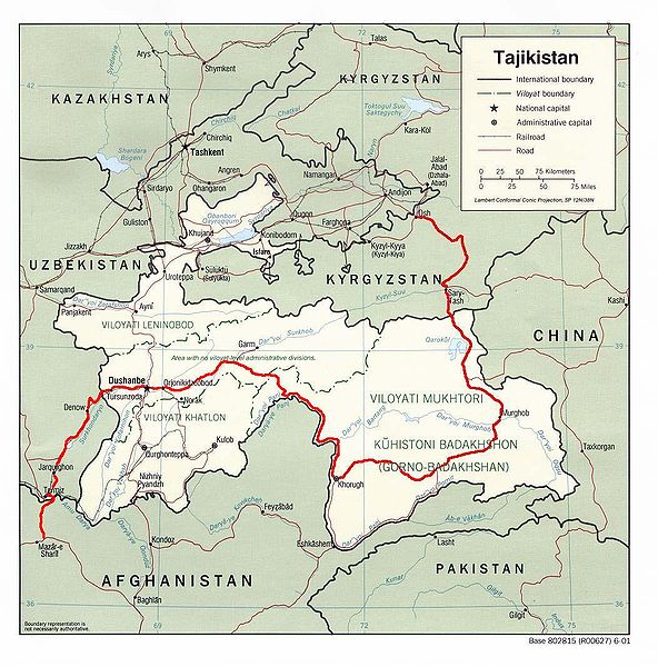
English: Map showing the route of the Pamir Highway through Afghanistan, Uzbekistan, Tajikistan, and Kyrgyzstan. |
| Date | |
| Source |
http://www.lib.utexas.edu/maps/tajikistan.html
|
| Auteur | Derived from CIA map by Bantman at en.wikipedia, transferred to Commons by User:Man77 using CommonsHelper. |
| Autorisation (Réutilisation de ce fichier) |
PD-USGOV; PD-AUTHOR. |
Conditions d’utilisation[modifier]
Ce média est dans le domaine public des États-Unis d’Amérique car son auteur est l’administration américaine comme précisé dans le code fédéral au Titre 17, Chapitre 1, Section 105. Pour en savoir plus : droit d’auteur.
Attention : Ceci ne concerne que le travail du Gouvernement Fédéral et pas celui des États, ou d’une autre subdivision géographique ou politique du pays.
|
 | |
| Ce fichier a été identifié comme étant exempt de restrictions connues liées au droit d’auteur, y compris tous les droits connexes et voisins. | ||
| Cette œuvre a été placée dans le domaine public par son auteur, Bantman. Ceci s’applique dans le monde entier. Dans certains pays, ceci peut ne pas être possible ; dans ce cas : Bantman accorde à toute personne le droit d’utiliser cette œuvre dans n’importe quel but, sans aucune condition, sauf celles requises par la loi.
|
Journal des téléversements d’origine[modifier]
La page de description originale était ici. Tous les noms d'utilisateur qui suivent se rapportent à en.wikipedia.
- 2005-08-30 22:02 Bantman 1052×1066× (204866 bytes) Map showing the route of the Pamir Highway through Afghanistan, Tajikistan, and Kyrgyzstan. Derived by me from a CIA map located at the [[University_of_Texas_at_Austin#Facilities|Perry-Castañeda Library (PCL) of the University of Tex
Historique du fichier
Cliquer sur une date et heure pour voir le fichier tel qu'il était à ce moment-là.
| Date et heure | Vignette | Dimensions | Utilisateur | Commentaire | |
|---|---|---|---|---|---|
| actuel | 11 avril 2009 à 13:36 | | 1 052 × 1 066 (200 kio) | File Upload Bot (Magnus Manske) (d | contributions) | {{BotMoveToCommons|en.wikipedia|year={{subst:CURRENTYEAR}}|month={{subst:CURRENTMONTHNAME}}|day={{subst:CURRENTDAY}}}} {{Information |Description={{en|Map showing the route of the en:Pamir Highway through en:Afghanistan, en:Tajikistan, |
Vous ne pouvez pas remplacer ce fichier.
Utilisations locales du fichier
Les 2 pages suivantes utilisent ce fichier :
Utilisations du fichier sur d’autres wikis
Les autres wikis suivants utilisent ce fichier :
- Utilisation sur ca.wikipedia.org
- Utilisation sur cs.wikipedia.org
- Utilisation sur de.wikipedia.org
- Utilisation sur en.wikipedia.org
- Utilisation sur es.wikipedia.org
- Utilisation sur fa.wikipedia.org
- Utilisation sur fr.wikipedia.org
- Utilisation sur hu.wikipedia.org
- Utilisation sur it.wikipedia.org
- Utilisation sur ja.wikipedia.org
- Utilisation sur ko.wikipedia.org
- Utilisation sur lt.wikipedia.org
- Utilisation sur lv.wikipedia.org
- Utilisation sur nl.wikipedia.org
- Utilisation sur pt.wikipedia.org
- Utilisation sur ru.wikipedia.org
- Utilisation sur sl.wikipedia.org
- Utilisation sur sv.wikipedia.org
- Utilisation sur uk.wikipedia.org
- Utilisation sur www.wikidata.org
- Utilisation sur zh.wikipedia.org