File:Panstwo mieclawa.svg
Zur Navigation springen
Zur Suche springen

Größe der PNG-Vorschau dieser SVG-Datei: 700 × 567 Pixel. Weitere Auflösungen: 296 × 240 Pixel | 593 × 480 Pixel | 948 × 768 Pixel | 1.264 × 1.024 Pixel | 2.529 × 2.048 Pixel.
Originaldatei (SVG-Datei, Basisgröße: 700 × 567 Pixel, Dateigröße: 3,21 MB)
Bildtexte
Kurzbeschreibungen
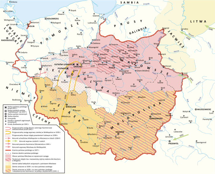
Der Staat Miecław und die Grenzen Polens im Jahr 1037
Beschreibung
[Bearbeiten]| Beschreibung |
Polski: Państwo Miecława oraz granice Polski w 1037 roku |
| Datum | |
| Quelle |
Eigenes Werk Book source: Janusz Bieniak Państwo Miecława. Studium Analityczne, PWN, 2012 |
| Urheber | Hoodinski |
| Andere Versionen |

Lizenz
[Bearbeiten]
Ich, der Urheber dieses Werkes, veröffentliche es unter der folgenden Lizenz:
Diese Datei ist unter der Creative-Commons-Lizenz „Namensnennung – Weitergabe unter gleichen Bedingungen 3.0 nicht portiert“ lizenziert.
- Dieses Werk darf von dir
- verbreitet werden – vervielfältigt, verbreitet und öffentlich zugänglich gemacht werden
- neu zusammengestellt werden – abgewandelt und bearbeitet werden
- Zu den folgenden Bedingungen:
- Namensnennung – Du musst angemessene Urheber- und Rechteangaben machen, einen Link zur Lizenz beifügen und angeben, ob Änderungen vorgenommen wurden. Diese Angaben dürfen in jeder angemessenen Art und Weise gemacht werden, allerdings nicht so, dass der Eindruck entsteht, der Lizenzgeber unterstütze gerade dich oder deine Nutzung besonders.
- Weitergabe unter gleichen Bedingungen – Wenn du das Material wiedermischst, transformierst oder darauf aufbaust, musst du deine Beiträge unter der gleichen oder einer kompatiblen Lizenz wie das Original verbreiten.
Dateiversionen
Klicke auf einen Zeitpunkt, um diese Version zu laden.
| Version vom | Vorschaubild | Maße | Benutzer | Kommentar | |
|---|---|---|---|---|---|
| aktuell | 17:31, 28. Jun. 2024 | | 700 × 567 (3,21 MB) | Bornholm (Diskussion | Beiträge) | Reverted to version as of 17:24, 7 February 2024 (UTC) The Yotvingians did not live further south than the course of the Narew rivers. This is confirmed archaeologically. There are also no reliable historical sources that confirm settlements south of this river. South of this river there are no traces of their settlement or other Baltic tribes. Invasions to the south were only robbery and never had a settlement character. |
| 18:32, 11. Feb. 2024 |  | 700 × 567 (3,3 MB) | +JMJ+ (Diskussion | Beiträge) | Reverted to version as of 21:38, 18 December 2023 (UTC) - "jotvingiai iki 12–13 a. pietuose gyvenę iki Bugo upės (Brastos-Drohičino apylinkėse)" (https://www.vle.lt/straipsnis/jotvingiai/). "until the 12th-13th centuries, Yotvingians lived in the south up to the Bug river (in the vicinity of Lithuanian Brest-Drohiczyn)". Yotvingian borders are ahistorically minimalized in this map and inaccurately depicted as part of Poland despite that not being the case. | |
| 17:24, 7. Feb. 2024 |  | 700 × 567 (3,21 MB) | Bornholm (Diskussion | Beiträge) | Reverted to version as of 21:43, 25 November 2023 (UTC) The Yotvingians did not live further south than the course of the Narew rivers. This is confirmed archaeologically. There are also no reliable historical sources that confirm settlements south of this river. South of this river there are no traces of their settlement or other Baltic tribes. Invasions to the south were only robbery and never had a settlement character. | |
| 21:38, 18. Dez. 2023 |  | 700 × 567 (3,3 MB) | +JMJ+ (Diskussion | Beiträge) | Reverted to version as of 16:12, 28 August 2023 (UTC) - revert to historically accurate version | |
| 21:43, 25. Nov. 2023 |  | 700 × 567 (3,21 MB) | Kamilhrub (Diskussion | Beiträge) | Reverted to version as of 10:48, 22 May 2023 (UTC) as in book source | |
| 16:12, 28. Aug. 2023 |  | 700 × 567 (3,3 MB) | +JMJ+ (Diskussion | Beiträge) | Reverted to version as of 10:07, 16 May 2023 (UTC) - https://www.vle.lt/straipsnis/jotvingiai/ says that "the Jotvingians lived in the south up to the Bug river (in the vicinity of Brasta-Drohičin) until the 12th-13th century." | |
| 10:48, 22. Mai 2023 |  | 700 × 567 (3,21 MB) | Bornholm (Diskussion | Beiträge) | Reverted to version as of 14:43, 27 March 2023 (UTC) The Yotvingians did not live further south than the course of the Narew rivers. This is confirmed archaeologically. There are also no reliable historical sources that confirm settlements south of this river. South of this river there are no traces of their settlement or other Baltic tribes. Invasions to the south were only robbery and never had a settlement character. | |
| 10:07, 16. Mai 2023 |  | 700 × 567 (3,3 MB) | +JMJ+ (Diskussion | Beiträge) | Reverted to version as of 07:52, 25 February 2023 (UTC) Yotvingians were indeed inhabiting that far south - they were fighting for their native lands there against various Slavs (including the Poles) still in the 12th century | |
| 14:43, 27. Mär. 2023 |  | 700 × 567 (3,21 MB) | Bornholm (Diskussion | Beiträge) | Correction of the Polish border with Yotvingians. Yotvingian tribes never had settlements so far south and never reached the Bug river. | |
| 07:52, 25. Feb. 2023 |  | 700 × 567 (3,3 MB) | ZxcvU (Diskussion | Beiträge) | Przemysl was under Kyivan Rus' control since Yaroslav's March on Poland in 1031 |
Du kannst diese Datei nicht überschreiben.
Dateiverwendung
Die folgenden 12 Seiten verwenden diese Datei:
- User:Hoodinski
- User:Magog the Ogre/Multilingual legend/2023 August 27-31
- User:Magog the Ogre/Multilingual legend/2023 December 17-21
- User:Magog the Ogre/Multilingual legend/2023 February 10-18
- User:Magog the Ogre/Multilingual legend/2023 February 19-28
- User:Magog the Ogre/Multilingual legend/2023 March 21-31
- User:Magog the Ogre/Multilingual legend/2023 May 11-20
- User:Magog the Ogre/Multilingual legend/2023 May 21-31
- User:Magog the Ogre/Multilingual legend/2024 February 10-14
- User:Magog the Ogre/Multilingual legend/2024 February 5-9
- User:Magog the Ogre/Multilingual legend/2024 June 26-30
- File:Panstwo mieclawa-es.svg
Globale Dateiverwendung
Die nachfolgenden anderen Wikis verwenden diese Datei:
- Verwendung auf de.wikipedia.org
- Verwendung auf en.wikipedia.org
- Verwendung auf ja.wikipedia.org
- Verwendung auf pl.wikipedia.org
- Verwendung auf ru.wikipedia.org
- Verwendung auf sl.wikipedia.org
- Verwendung auf sv.wikipedia.org
- Verwendung auf uk.wikipedia.org
- Verwendung auf www.wikidata.org
Metadaten
Kategorien:
- Maps of the Kingdom of Poland (Piasts)
- SVG maps of the history of Belarus
- Maps of Balts
- Maps of Silesia
- Maps of the history of Bohemia and Moravia
- Maps of the military history of Poland
- Maps showing 11th-century history
- Territorial evolution of Poland
- SVG maps of the history of Poland
- Polish-language SVG maps showing history