File:Panstwo mieclawa.svg
ナビゲーションに移動
検索に移動

この SVG ファイルのこの PNG プレビューのサイズ: 700 × 567 ピクセル. その他の解像度: 296 × 240 ピクセル | 593 × 480 ピクセル | 948 × 768 ピクセル | 1,264 × 1,024 ピクセル | 2,529 × 2,048 ピクセル。
元のファイル (SVG ファイル、700 × 567 ピクセル、ファイルサイズ: 3.3メガバイト)
キャプション
キャプション
このファイルの内容を1行で記述してください
概要[編集]
| 解説 |
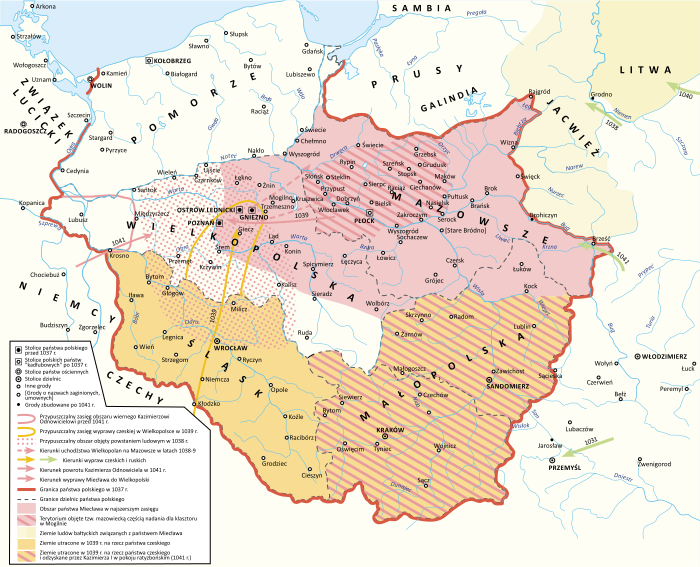
Polski: Państwo Miecława oraz granice Polski w 1037 roku |
| 日付 | |
| 原典 |
投稿者自身による著作物 Book source: Janusz Bieniak Państwo Miecława. Studium Analityczne, PWN, 2012 |
| 作者 | Hoodinski |
| その他のバージョン |

ライセンス[編集]
この作品の著作権者である私は、この作品を以下のライセンスで提供します。
このファイルはクリエイティブ・コモンズ 表示-継承 3.0 非移植ライセンスのもとに利用を許諾されています。
- あなたは以下の条件に従う場合に限り、自由に
- 共有 – 本作品を複製、頒布、展示、実演できます。
- 再構成 – 二次的著作物を作成できます。
- あなたの従うべき条件は以下の通りです。
- 表示 – あなたは適切なクレジットを表示し、ライセンスへのリンクを提供し、変更があったらその旨を示さなければなりません。これらは合理的であればどのような方法で行っても構いませんが、許諾者があなたやあなたの利用行為を支持していると示唆するような方法は除きます。
- 継承 – もしあなたがこの作品をリミックスしたり、改変したり、加工した場合には、あなたはあなたの貢献部分を元の作品とこれと同一または互換性があるライセンスの下に頒布しなければなりません。
ファイルの履歴
過去の版のファイルを表示するには、その版の日時をクリックしてください。
| 日付と時刻 | サムネイル | 寸法 | 利用者 | コメント | |
|---|---|---|---|---|---|
| 現在の版 | 2024年2月11日 (日) 18:32 | | 700 × 567 (3.3メガバイト) | +JMJ+ (トーク | 投稿記録) | Reverted to version as of 21:38, 18 December 2023 (UTC) - "jotvingiai iki 12–13 a. pietuose gyvenę iki Bugo upės (Brastos-Drohičino apylinkėse)" (https://www.vle.lt/straipsnis/jotvingiai/). "until the 12th-13th centuries, Yotvingians lived in the south up to the Bug river (in the vicinity of Lithuanian Brest-Drohiczyn)". Yotvingian borders are ahistorically minimalized in this map and inaccurately depicted as part of Poland despite that not being the case. |
| 2024年2月7日 (水) 17:24 |  | 700 × 567 (3.21メガバイト) | Bornholm (トーク | 投稿記録) | Reverted to version as of 21:43, 25 November 2023 (UTC) The Yotvingians did not live further south than the course of the Narew rivers. This is confirmed archaeologically. There are also no reliable historical sources that confirm settlements south of this river. South of this river there are no traces of their settlement or other Baltic tribes. Invasions to the south were only robbery and never had a settlement character. | |
| 2023年12月18日 (月) 21:38 |  | 700 × 567 (3.3メガバイト) | +JMJ+ (トーク | 投稿記録) | Reverted to version as of 16:12, 28 August 2023 (UTC) - revert to historically accurate version | |
| 2023年11月25日 (土) 21:43 |  | 700 × 567 (3.21メガバイト) | Kamilhrub (トーク | 投稿記録) | Reverted to version as of 10:48, 22 May 2023 (UTC) as in book source | |
| 2023年8月28日 (月) 16:12 |  | 700 × 567 (3.3メガバイト) | +JMJ+ (トーク | 投稿記録) | Reverted to version as of 10:07, 16 May 2023 (UTC) - https://www.vle.lt/straipsnis/jotvingiai/ says that "the Jotvingians lived in the south up to the Bug river (in the vicinity of Brasta-Drohičin) until the 12th-13th century." | |
| 2023年5月22日 (月) 10:48 |  | 700 × 567 (3.21メガバイト) | Bornholm (トーク | 投稿記録) | Reverted to version as of 14:43, 27 March 2023 (UTC) The Yotvingians did not live further south than the course of the Narew rivers. This is confirmed archaeologically. There are also no reliable historical sources that confirm settlements south of this river. South of this river there are no traces of their settlement or other Baltic tribes. Invasions to the south were only robbery and never had a settlement character. | |
| 2023年5月16日 (火) 10:07 |  | 700 × 567 (3.3メガバイト) | +JMJ+ (トーク | 投稿記録) | Reverted to version as of 07:52, 25 February 2023 (UTC) Yotvingians were indeed inhabiting that far south - they were fighting for their native lands there against various Slavs (including the Poles) still in the 12th century | |
| 2023年3月27日 (月) 14:43 |  | 700 × 567 (3.21メガバイト) | Bornholm (トーク | 投稿記録) | Correction of the Polish border with Yotvingians. Yotvingian tribes never had settlements so far south and never reached the Bug river. | |
| 2023年2月25日 (土) 07:52 |  | 700 × 567 (3.3メガバイト) | ZxcvU (トーク | 投稿記録) | Przemysl was under Kyivan Rus' control since Yaroslav's March on Poland in 1031 | |
| 2023年2月17日 (金) 16:18 |  | 700 × 567 (3.29メガバイト) | +JMJ+ (トーク | 投稿記録) | Corrections of Poland's eastern borders. Yotvingia was far larger at the time. |
このファイルは上書きできません。
ファイルの使用状況
以下の 11 ページがこのファイルを使用しています:
- User:Hoodinski
- User:Magog the Ogre/Multilingual legend/2023 August 27-31
- User:Magog the Ogre/Multilingual legend/2023 December 17-21
- User:Magog the Ogre/Multilingual legend/2023 February 10-18
- User:Magog the Ogre/Multilingual legend/2023 February 19-28
- User:Magog the Ogre/Multilingual legend/2023 March 21-31
- User:Magog the Ogre/Multilingual legend/2023 May 11-20
- User:Magog the Ogre/Multilingual legend/2023 May 21-31
- User:Magog the Ogre/Multilingual legend/2024 February 10-14
- User:Magog the Ogre/Multilingual legend/2024 February 5-9
- File:Panstwo mieclawa-es.svg
グローバルなファイル使用状況
以下に挙げる他のウィキがこの画像を使っています:
- de.wikipedia.org での使用状況
- en.wikipedia.org での使用状況
- ja.wikipedia.org での使用状況
- mt.wikipedia.org での使用状況
- pl.wikipedia.org での使用状況
- Kazimierz I Odnowiciel
- Mazowsze
- Polska wczesnopiastowska
- Mazury
- Miecław
- Bitwa Kazimierza I z Miecławem
- Powstanie ludowe w Polsce
- Reakcja pogańska
- Historia Polski (do 1138)
- Wikipedysta:Hoodinski
- Układ ratyzboński
- Najazd Brzetysława
- Państwo Miecława
- Wikipedysta:Luki1223/brudnopis
- Wikipedysta:Malarz pl/szablony/Państwo stary szablon infobox
- Wikipedysta:Malarz pl/szablony/Państwo stary szablon infobox/26
- ru.wikipedia.org での使用状況
- sl.wikipedia.org での使用状況
- sv.wikipedia.org での使用状況
- uk.wikipedia.org での使用状況
- www.wikidata.org での使用状況
メタデータ
カテゴリ:
- Maps of the Kingdom of Poland (Piasts)
- SVG maps of the history of Belarus
- Maps of Balts
- Maps of Silesia
- Maps of the history of Bohemia and Moravia
- Maps of the military history of Poland
- Maps showing 11th-century history
- Territorial evolution of Poland
- SVG maps of the history of Poland
- Polish-language SVG maps showing history