File:Paraná River Floodplain.jpg
ナビゲーションに移動
検索に移動
高解像度版はありません。
Paraná_River_Floodplain.jpg (720 × 480 ピクセル、ファイルサイズ: 179キロバイト、MIME タイプ: image/jpeg)
キャプション
キャプション
このファイルの内容を1行で記述してください
Paraná River Floodplain in Brazil
| 解説 |
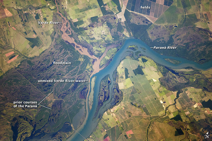
English: Paraná River Floodplain, Brazil
The Paraná River appears as a wide, blue strip with the muddy brown water of the smaller Verde River entering from the northwest (top left). An extensive wetland (dark green) occupies most of the left half of this astronaut photograph, and the floodplain reaches a width of 11 kilometers (about 7 miles). The thin line of a road crossing the floodplain also gives a sense of scale. Above the Paraná-Verde confluence (image center), the floodplain is much narrower. |
|||||
| 日付 | acquired on February 5, 2012 | |||||
| 原典 | http://earthobservatory.nasa.gov/IOTD/view.php?id=77444&src=eoa-iotd | |||||
| 作者 | NASA Astronaut photograph ISS030-E-90012 | |||||
| 許可 (ファイルの再利用) |
|
|||||
| その他のバージョン | See [1] for a larger version |

![[1]](http://eoimages.gsfc.nasa.gov/images/imagerecords/77000/77444/ISS030-E-090012_lrg.jpg)
ファイルの履歴
過去の版のファイルを表示するには、その版の日時をクリックしてください。
| 日付と時刻 | サムネイル | 寸法 | 利用者 | コメント | |
|---|---|---|---|---|---|
| 現在の版 | 2012年3月22日 (木) 18:28 | | 720 × 480 (179キロバイト) | Tillman (トーク | 投稿記録) | {{Information |Description ={{en|1=Paraná River Floodplain, Brazil The Paraná River appears as a wide, blue strip with the muddy brown water of the smaller Verde River entering from the northwest (top left). An extensive wetland (dark green) occu... |
このファイルは上書きできません。
ファイルの使用状況
以下のページがこのファイルを使用しています:
グローバルなファイル使用状況
以下に挙げる他のウィキがこの画像を使っています:
- ba.wikipedia.org での使用状況
- bh.wikipedia.org での使用状況
- bn.wikipedia.org での使用状況
- ca.wikipedia.org での使用状況
- din.wikipedia.org での使用状況
- en.wikipedia.org での使用状況
- eo.wikipedia.org での使用状況
- fi.wikipedia.org での使用状況
- ja.wikipedia.org での使用状況
- sl.wikipedia.org での使用状況
- sr.wikipedia.org での使用状況
- uk.wikipedia.org での使用状況
- vi.wikipedia.org での使用状況
- war.wikipedia.org での使用状況
- www.wikidata.org での使用状況
- zh.wikipedia.org での使用状況