File:Patagonia Snow.jpg
跳转到导航
跳转到搜索

本预览的尺寸:463 × 599像素。 其他分辨率:185 × 240像素 | 371 × 480像素 | 850 × 1,100像素。
原始文件 (850 × 1,100像素,文件大小:903 KB,MIME类型:image/jpeg)
说明
说明
添加一行文字以描述该文件所表现的内容
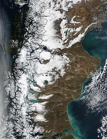
| 描述 | Snow runs down the spine of the Andes Mountains along the southern tip of South America. Chile is on the left, and Argentina is on the right. The water cutting across the continent in the bottom center of the image is the Strait of Magellan, once the only safe route between the Atlantic and the Pacific Oceans. Along the coast of Argentina, waters of the Atlantic Ocean are tinted green with sediment. |
| 日期 | |
| 来源 | http://visibleearth.nasa.gov/view_rec.php?id=6061 |
| 作者 | Jacques Descloitres, MODIS Rapid Response Team, NASA/GSFC |
| 本文件完全由NASA创作,在美国属于公有领域。根据NASA的版权方针,NASA的材料除非另有声明否则不受版权保护。(参见Template:PD-USGov/zh、NASA版权方针页面或JPL图片使用方针。) | ||
 |
警告:
|
文件历史
点击某个日期/时间查看对应时刻的文件。
| 日期/时间 | 缩略图 | 大小 | 用户 | 备注 | |
|---|---|---|---|---|---|
| 当前 | 2017年10月30日 (一) 02:28 | | 850 × 1,100(903 KB) | Janitoalevic(留言 | 贡献) | 1998 borders applied. |
| 2006年12月12日 (二) 04:16 |  | 850 × 1,100(323 KB) | Mokono(留言 | 贡献) | An Image of the Ptatagonian winter Taken by the Nasa |
您不可以覆盖此文件。
文件用途
全域文件用途
以下其他wiki使用此文件:
- af.wikipedia.org上的用途
- ca.wikipedia.org上的用途
- de.wikipedia.org上的用途
- el.wikipedia.org上的用途
- es.wikipedia.org上的用途
- it.wikipedia.org上的用途
- ja.wikipedia.org上的用途
- lv.wikipedia.org上的用途
- nn.wikipedia.org上的用途
- pt.wikipedia.org上的用途
- uk.wikipedia.org上的用途
- zh.wikipedia.org上的用途