File:Pedra Branca Map.svg
ナビゲーションに移動
検索に移動

この SVG ファイルのこの PNG プレビューのサイズ: 800 × 487 ピクセル. その他の解像度: 320 × 195 ピクセル | 640 × 390 ピクセル | 1,024 × 624 ピクセル | 1,280 × 779 ピクセル | 2,560 × 1,559 ピクセル | 3,478 × 2,118 ピクセル。
元のファイル (SVG ファイル、3,478 × 2,118 ピクセル、ファイルサイズ: 230キロバイト)
キャプション
キャプション
このファイルの内容を1行で記述してください
概要[編集]
| 解説 |
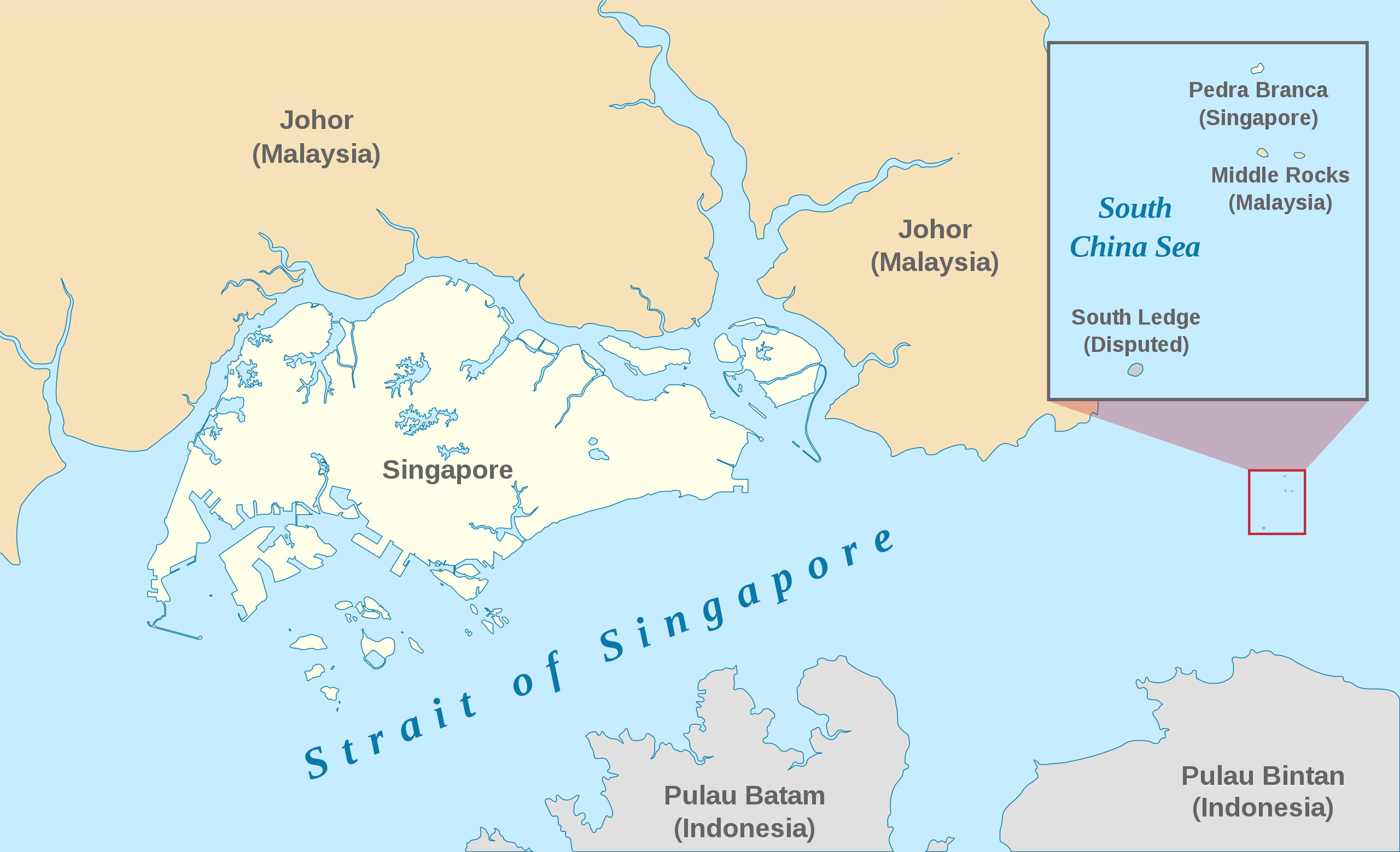
English: A map showing the approximate location of the island of Pedra Branca, which is under the sovereignty of Singapore, at the eastern end of the Singapore Strait where it meets the South China Sea. Near it are the maritime features Middle Rocks (under Malaysian sovereignty) and South Ledge, and the coasts of Johor, Malaysia, and Bintan, Indonesia. |
| 日付 | |
| 原典 | Self-made, modified from Image:Singapore Outline.svg. |
| 作者 | Jappalang. |
| 許可 (ファイルの再利用) |
PD-Self. |
ライセンス[編集]
| この著作物の著作権者である私は、この著作物における権利を放棄しパブリックドメインとします。これは全世界で適用されます。 一部の国では、これが法的に可能ではない場合があります。その場合は、次のように宣言します。 私は、あらゆる人に対して、法により必要とされている条件を除き、如何なる条件も課すことなく、あらゆる目的のためにこの著作物を使用する権利を与えます。 |
ファイルの履歴
過去の版のファイルを表示するには、その版の日時をクリックしてください。
| 日付と時刻 | サムネイル | 寸法 | 利用者 | コメント | |
|---|---|---|---|---|---|
| 現在の版 | 2021年1月13日 (水) 06:27 | | 3,478 × 2,118 (230キロバイト) | Seloloving (トーク | 投稿記録) | recoloured to Wikipedia map colour style |
| 2020年2月9日 (日) 09:59 |  | 3,478 × 2,118 (219キロバイト) | *angys* (トーク | 投稿記録) | File uploaded using svgtranslate tool (https://tools.wmflabs.org/svgtranslate/). Added translation for zh. | |
| 2017年10月22日 (日) 14:36 |  | 3,478 × 2,118 (208キロバイト) | Seloloving (トーク | 投稿記録) | Fixed spelling error with "Enlargement" | |
| 2017年10月22日 (日) 14:34 |  | 3,478 × 2,118 (208キロバイト) | Seloloving (トーク | 投稿記録) | Recolored claimant states to a more neutral colour. Shifted the Insert Map further up and added note to clarify its actual location. Changed fonts and colours to align with Wikipedia Map guidelines. | |
| 2014年5月24日 (土) 19:42 |  | 3,261 × 1,986 (194キロバイト) | Seloloving (トーク | 投稿記録) | Fixed text rendering. Fixed map. | |
| 2014年5月4日 (日) 05:36 |  | 3,261 × 1,986 (276キロバイト) | Seloloving (トーク | 投稿記録) | Fixed Johor's shape. | |
| 2014年5月4日 (日) 05:24 |  | 3,261 × 1,986 (274キロバイト) | Seloloving (トーク | 投稿記録) | Fixed font problems. | |
| 2014年5月4日 (日) 05:20 |  | 3,261 × 1,986 (273キロバイト) | Seloloving (トーク | 投稿記録) | Fixed problems. | |
| 2014年5月4日 (日) 05:12 |  | 3,261 × 1,986 (282キロバイト) | Seloloving (トーク | 投稿記録) | Fixed geography of the islands. | |
| 2008年9月30日 (火) 04:05 |  | 3,261 × 1,986 (396キロバイト) | Jappalang (トーク | 投稿記録) | "South Lodge" corrected to "South Ledge" |
このファイルは上書きできません。
ファイルの使用状況
以下のページがこのファイルを使用しています:
グローバルなファイル使用状況
以下に挙げる他のウィキがこの画像を使っています:
- de.wikipedia.org での使用状況
- en.wikipedia.org での使用状況
- es.wikipedia.org での使用状況
- fr.wikipedia.org での使用状況
- he.wikipedia.org での使用状況
- id.wikipedia.org での使用状況
- it.wikipedia.org での使用状況
- ja.wikipedia.org での使用状況
- ko.wikipedia.org での使用状況
- mdf.wikipedia.org での使用状況
- ms.wikipedia.org での使用状況
- pt.wikipedia.org での使用状況
- ru.wikipedia.org での使用状況
- ta.wikipedia.org での使用状況
- th.wikipedia.org での使用状況
- vi.wikipedia.org での使用状況
- zh.wikipedia.org での使用状況