File:Ph fil western visayas.png
Spring til navigation
Spring til søgning
Størrelse af denne forhåndsvisning: 384 × 599 pixels. Andre opløsninger: 154 × 240 pixels | 308 × 480 pixels | 492 × 768 pixels | 656 × 1.024 pixels | 2.000 × 3.120 pixels.
Oprindelig fil (2.000 × 3.120 billedpunkter, filstørrelse: 137 KB, MIME-type: image/png)
Captions
Captions
Tilføj en kort forklaring på en enkelt linje om hvad filen viser
Beskrivelse
[redigér]
| Beskrivelse |
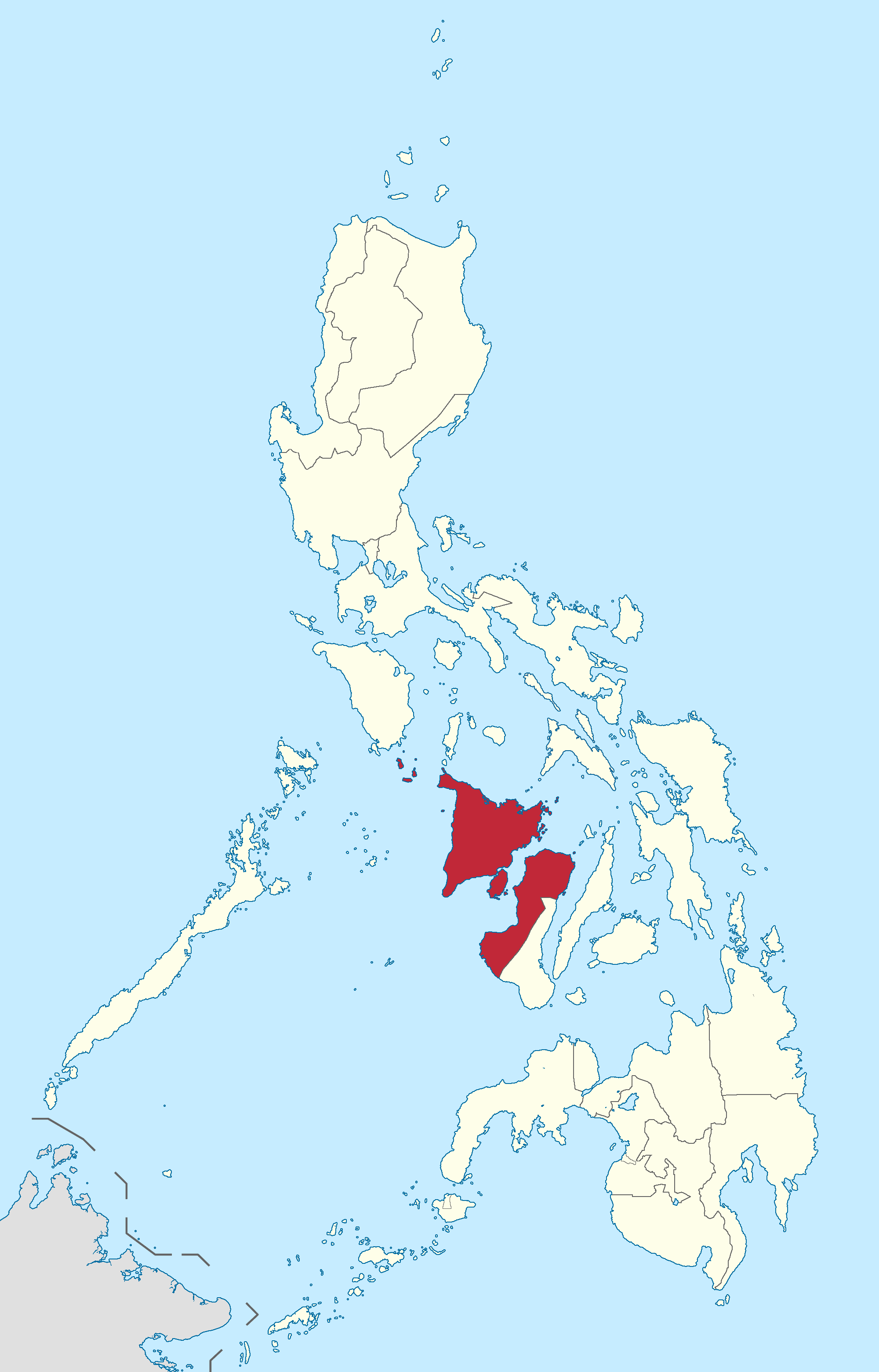
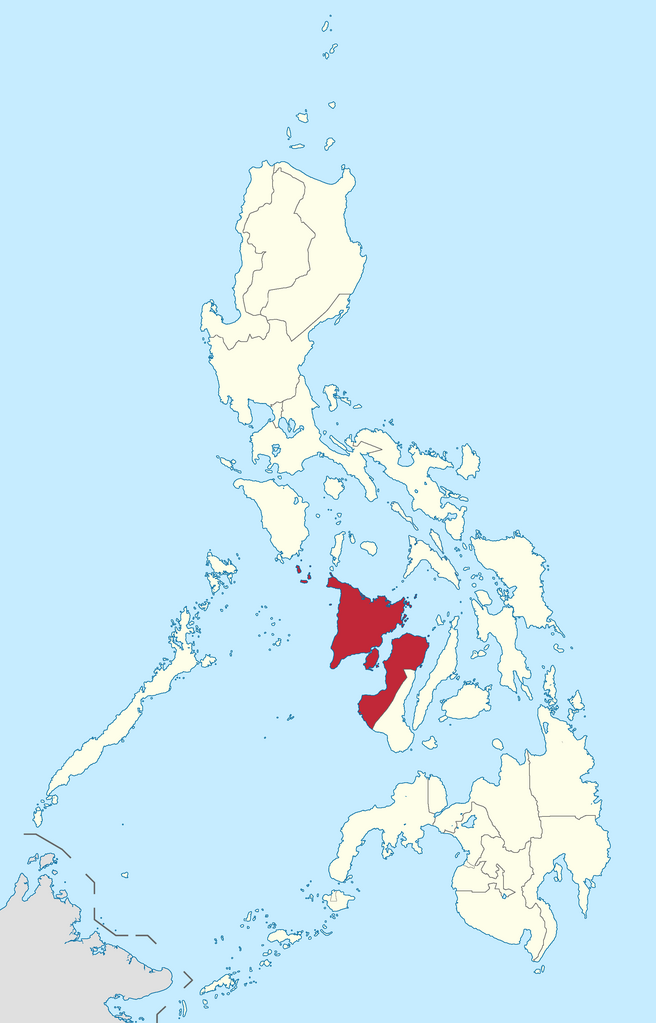
English: Location of Western Visayas region in the Philippines.
Filipino: Kinaroroonan ng rehiyon ng Kanlurang Visayas sa Pilipinas. |
| Dato | |
| Kilde |
BlankMap-Philippines.png by User:TheCoffee
|
| Forfatter | Roel Balingit |
Licensering
[redigér]
Jeg, dette værks ophavsretsindehaver, publicerer hermed værket under den følgende licens:
Denne fil er udgivet under Creative Commons Kreditering-Del på samme vilkår 3.0 Ikke-porteret-licensen.
- Du må frit:
- at dele – at kopiere, distribuere og overføre værket
- at remixe – at tilpasse værket
- Under følgende vilkår:
- kreditering – Du skal give passende kreditering, angive et link til licensen, og oplyse om der er foretaget ændringer. Du må gøre det på enhver fornuftig måde, men ikke på en måde der antyder at licensgiveren godkender dig eller din anvendelse.
- deling på samme vilkår – Hvis du bearbejder, ændrer eller bygger videre på dette værk, skal du distribuere dine bidrag under den samme eller en kompatibel licens som originalen.

|
If you choose to use this work under the Creative Commons license stated above, the author, Roel Balingit (Namayan), would like you to attribute the work to him (among other requirements such as indicating that the work is licensed under the Creative Commons) with the following text or similar:
© Roel Balingit, 2012.
His name should be a link to the Wikimedia Commons userpage Namayan. If a link is not possible, then the url should be placed in parentheses after the name. If the work has been substantially altered by other people (see the File history section below), then this particular attribution requirement is waived, which means you can attribute the work in any reasonable manner. This attribution requirement is provided pursuant to the Creative Commons Attribution mechanism where "you must attribute the work in the manner specified by the author or licensor (but not in any way that suggests that they endorse you or your use of the work)." (See "Attribution" in the Creative Commons website.)
|
Filhistorik
Klik på en dato/tid for at se filen som den så ud på det tidspunkt.
| Dato/tid | Miniaturebillede | Dimensioner | Bruger | Kommentar | |
|---|---|---|---|---|---|
| nuværende | 20. sep. 2017, 18:13 | | 2.000 × 3.120 (137 KB) | Seav (diskussion | bidrag) | Reverted to version as of 13:52, 9 August 2017 (UTC) |
| 2. sep. 2017, 08:40 |  | 2.000 × 3.120 (136 KB) | Tekken Network (diskussion | bidrag) | Reverted to version as of 03:52, 1 September 2017 (UTC) | |
| 1. sep. 2017, 04:00 |  | 2.000 × 3.120 (137 KB) | Tekken Network (diskussion | bidrag) | Reverted to version as of 13:52, 9 August 2017 (UTC) | |
| 1. sep. 2017, 03:52 |  | 2.000 × 3.120 (136 KB) | Tekken Network (diskussion | bidrag) | Reverted to version as of 10:12, 5 June 2015 (UTC) | |
| 9. aug. 2017, 13:52 |  | 2.000 × 3.120 (137 KB) | Hariboneagle927 (diskussion | bidrag) | Reverted to version as of 03:20, 15 August 2012 (UTC) NIR is abolished | |
| 5. jun. 2015, 10:12 |  | 2.000 × 3.120 (136 KB) | Namayan (diskussion | bidrag) | Negros Occidental transferred to Negros Island Region | |
| 15. aug. 2012, 03:20 |  | 2.000 × 3.120 (137 KB) | Namayan (diskussion | bidrag) |
Du kan ikke overskrive denne fil.
Filanvendelse
De følgende 3 sider bruger denne fil:
Global filanvendelse
Følgende andre wikier anvender denne fil:
- Anvendelser på af.wikipedia.org
- Anvendelser på an.wikipedia.org
- Anvendelser på ar.wikipedia.org
- Anvendelser på bcl.wikipedia.org
- Anvendelser på ca.wikipedia.org
- Anvendelser på cbk-zam.wikipedia.org
- Anvendelser på de.wikipedia.org
- Anvendelser på de.wikivoyage.org
- Anvendelser på en.wikipedia.org
- Leganes, Iloilo
- Aklan River
- Altavas
- Libacao
- Makato
- Sibunag
- San Lorenzo, Guimaras
- Nueva Valencia
- Anini-y
- Libertad, Antique
- Valderrama, Antique
- Dao, Capiz
- Dumalag
- Dumarao
- Ivisan
- Jamindan
- Mambusao
- Panitan
- Pontevedra, Capiz
- Sigma, Capiz
- Anilao, Iloilo
- Badiangan
- Batad, Iloilo
- Lambunao
- Lemery, Iloilo
- Leon, Iloilo
- Maasin, Iloilo
- San Dionisio, Iloilo
- San Miguel, Iloilo
- Zarraga
- Panay River
- Manduyog Hill
- Nogas Island
- Tabon, Batan
- Iloilo Strait
- Taklong Island
- Magosipal Islet
- Pangalan Islet
- Tago Island
- Danao-Danao Island
- Bocot Island
Vis flere globale anvendelser af denne fil.