File:Ph fil western visayas.png
File originale (2 000 × 3 120 pixel, dimensione del file: 137 KB, tipo MIME: image/png)
Didascalie
Didascalie
Dettagli[modifica]
| Descrizione |
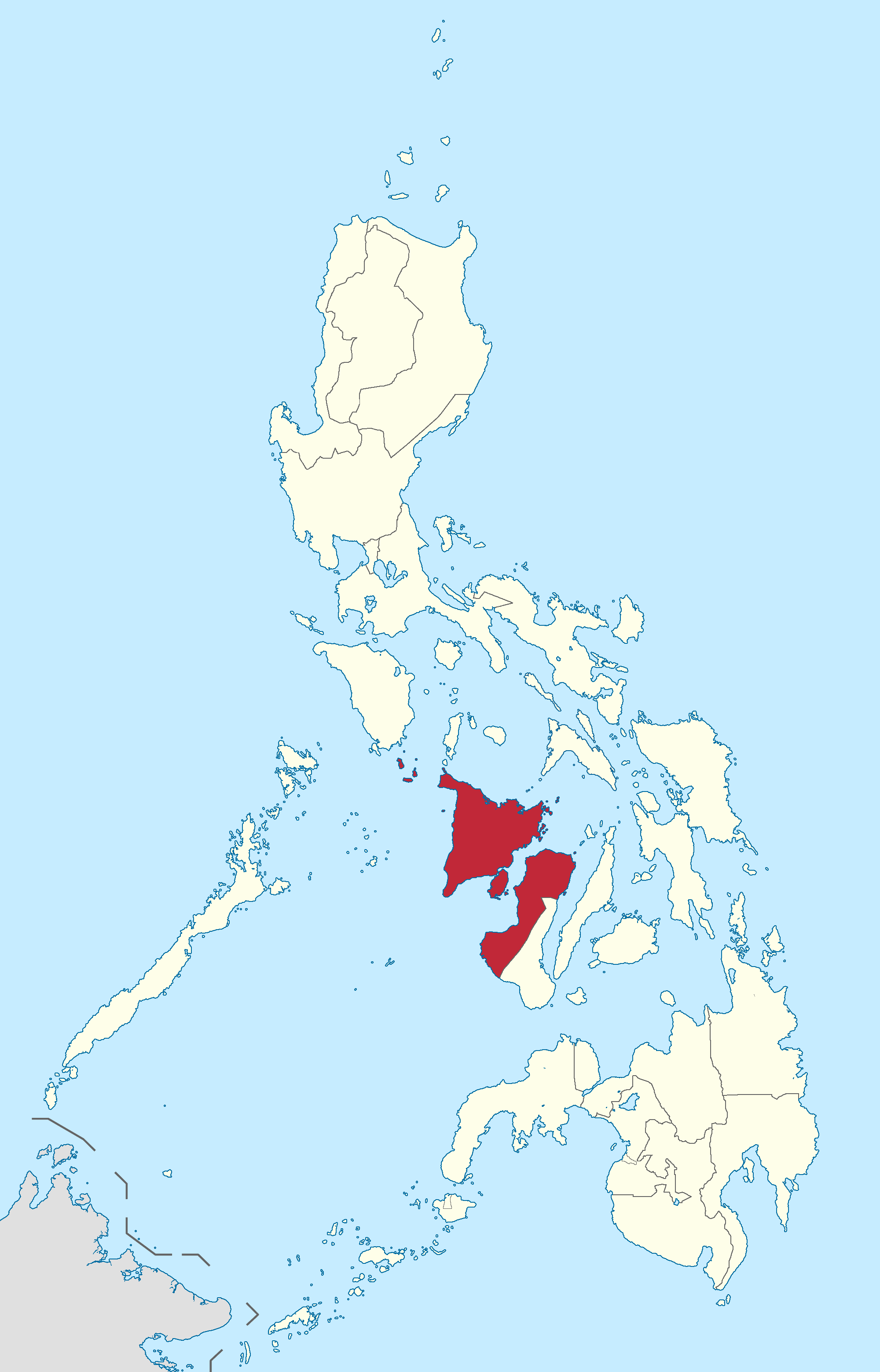
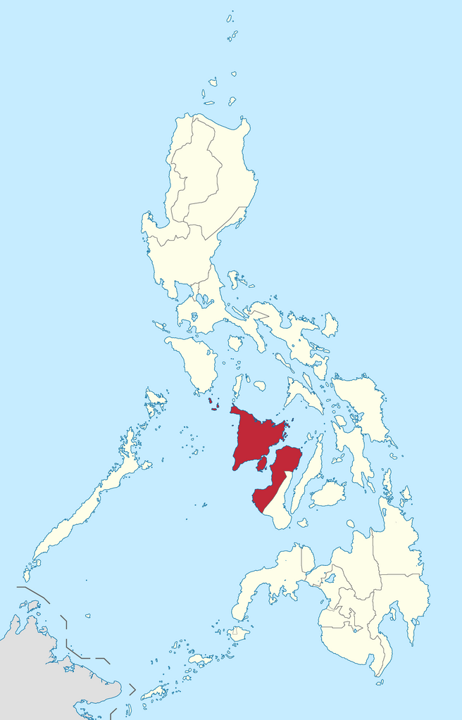
English: Location of Western Visayas region in the Philippines.
Filipino: Kinaroroonan ng rehiyon ng Kanlurang Visayas sa Pilipinas. |
| Data | |
| Fonte |
BlankMap-Philippines.png by User:TheCoffee
|
| Autore | Roel Balingit |
Licenza[modifica]
- Tu sei libero:
- di condividere – di copiare, distribuire e trasmettere quest'opera
- di modificare – di adattare l'opera
- Alle seguenti condizioni:
- attribuzione – Devi fornire i crediti appropriati, un collegamento alla licenza e indicare se sono state apportate modifiche. Puoi farlo in qualsiasi modo ragionevole, ma non in alcun modo che suggerisca che il licenziante approvi te o il tuo uso.
- condividi allo stesso modo – Se remixi, trasformi o sviluppi il materiale, devi distribuire i tuoi contributi in base alla stessa licenza o compatibile all'originale.

|
If you choose to use this work under the Creative Commons license stated above, the author, Roel Balingit (Namayan), would like you to attribute the work to him (among other requirements such as indicating that the work is licensed under the Creative Commons) with the following text or similar:
© Roel Balingit, 2012.
His name should be a link to the Wikimedia Commons userpage Namayan. If a link is not possible, then the url should be placed in parentheses after the name. If the work has been substantially altered by other people (see the File history section below), then this particular attribution requirement is waived, which means you can attribute the work in any reasonable manner. This attribution requirement is provided pursuant to the Creative Commons Attribution mechanism where "you must attribute the work in the manner specified by the author or licensor (but not in any way that suggests that they endorse you or your use of the work)." (See "Attribution" in the Creative Commons website.)
|
Cronologia del file
Fare clic su un gruppo data/ora per vedere il file come si presentava nel momento indicato.
| Data/Ora | Miniatura | Dimensioni | Utente | Commento | |
|---|---|---|---|---|---|
| attuale | 18:13, 20 set 2017 | | 2 000 × 3 120 (137 KB) | Seav (discussione | contributi) | Reverted to version as of 13:52, 9 August 2017 (UTC) |
| 08:40, 2 set 2017 |  | 2 000 × 3 120 (136 KB) | Tekken Network (discussione | contributi) | Reverted to version as of 03:52, 1 September 2017 (UTC) | |
| 04:00, 1 set 2017 |  | 2 000 × 3 120 (137 KB) | Tekken Network (discussione | contributi) | Reverted to version as of 13:52, 9 August 2017 (UTC) | |
| 03:52, 1 set 2017 |  | 2 000 × 3 120 (136 KB) | Tekken Network (discussione | contributi) | Reverted to version as of 10:12, 5 June 2015 (UTC) | |
| 13:52, 9 ago 2017 |  | 2 000 × 3 120 (137 KB) | Hariboneagle927 (discussione | contributi) | Reverted to version as of 03:20, 15 August 2012 (UTC) NIR is abolished | |
| 10:12, 5 giu 2015 |  | 2 000 × 3 120 (136 KB) | Namayan (discussione | contributi) | Negros Occidental transferred to Negros Island Region | |
| 03:20, 15 ago 2012 |  | 2 000 × 3 120 (137 KB) | Namayan (discussione | contributi) |
Impossibile sovrascrivere questo file.
Utilizzo del file
Le seguenti 3 pagine usano questo file:
Utilizzo globale del file
Anche i seguenti wiki usano questo file:
- Usato nelle seguenti pagine di af.wikipedia.org:
- Usato nelle seguenti pagine di an.wikipedia.org:
- Usato nelle seguenti pagine di ar.wikipedia.org:
- Usato nelle seguenti pagine di bcl.wikipedia.org:
- Usato nelle seguenti pagine di ca.wikipedia.org:
- Usato nelle seguenti pagine di cbk-zam.wikipedia.org:
- Usato nelle seguenti pagine di de.wikipedia.org:
- Usato nelle seguenti pagine di de.wikivoyage.org:
- Usato nelle seguenti pagine di en.wikipedia.org:
- Leganes, Iloilo
- Aklan River
- Altavas
- Libacao
- Makato
- Sibunag
- San Lorenzo, Guimaras
- Nueva Valencia
- Anini-y
- Libertad, Antique
- Valderrama, Antique
- Dao, Capiz
- Dumalag
- Dumarao
- Ivisan
- Jamindan
- Mambusao
- Panitan
- Pontevedra, Capiz
- Sigma, Capiz
- Anilao, Iloilo
- Badiangan
- Batad, Iloilo
- Lambunao
- Lemery, Iloilo
- Leon, Iloilo
- Maasin, Iloilo
- San Dionisio, Iloilo
- San Miguel, Iloilo
- Zarraga
- Panay River
- Manduyog Hill
- Nogas Island
- Tabon, Batan
- Iloilo Strait
- Taklong Island
- Magosipal Islet
- Pangalan Islet
- Tago Island
- Danao-Danao Island
- Bocot Island
Visualizza l'utilizzo globale di questo file.